Difference between revisions of "2024-05-17 48 10"
([retro picture]Proof) |
m (Location) |
||
| (4 intermediate revisions by one other user not shown) | |||
| Line 14: | Line 14: | ||
== Location == | == Location == | ||
<!-- where you've surveyed the hash to be --> | <!-- where you've surveyed the hash to be --> | ||
| + | In the forest near Pappenheim. | ||
== Participants == | == Participants == | ||
| Line 19: | Line 20: | ||
--> | --> | ||
| − | + | [[User:Torodeas|Torodeas]] ([[User talk:Torodeas|talk]]) | |
| − | |||
== Expedition == | == Expedition == | ||
<!-- how it all turned out. your narrative goes here. --> | <!-- how it all turned out. your narrative goes here. --> | ||
| + | A hash in the ~4% of [[48,10]] that belong to [[wikipedia:Middle_Franconia|Middle Franconia]]? And reachable after work? Great! | ||
| + | So depart work southbound, via Nuremberg and Trechtlingen to Pappenheim. | ||
| + | |||
| + | I feel like an unexpectedly large percentage of my hashes uses this railway out of Nuremberg: | ||
| + | [[2023-10-17_49_11]] in Roth, [[2023-10-05_49_11]] in Oberheckenhofen, [[2023-08-25_48_11]] in Dollnstein and [[2023-10-03_48_10]] in Rain all used it. | ||
| + | Since I don't use that train in my usual connections, by now, I am already conditioned to think of hashes when I enter that train (and to remember fondly the expeditions I did when their respective stations are annoucned). | ||
| + | |||
| + | Today's hash puts me on the exact same route I took for my third hash [[2023-08-25 48 11]] in Dollnstein, only that I leave the final train two stations early. Without issues or delays, I reach Pappenheim train station. | ||
| + | |||
| + | There are no good paths from the station to the hash. It's not far (600 meters), but the primary connection to it would include a street that is too busy to walk there, but probably without a usable footpath. After some back-and-forth, I decide to get a little bit closer to the hash on less used, residential streets, and look for any path through the forest for the last 500 meters. | ||
| + | |||
| + | As with Dollnstein, this plan underestimated the elevation changes. It's quite hilly here, and crossing into the forest sometimes includes quite significant in- or declines. I am happy where I can follow some unmarked paths, but my compass frequently tells me to leave the path and forge my own one towards the hash. | ||
| + | |||
| + | After a bit of trail-and-error, I arrive to the south (and quite significantly up in elevation) to both the hash and the street I wanted to avoid using. Now, one large (and quite steep) decline has to be the last part of my expedition, since the hash seems to be somewhere on it. Unclear if I will be able to walk down safely, I take the picture of it (you can see it in the gallery, but it looks less impressive there than I felt at the moment). If I don't make it to the hash, that'll be my closest distance to it. | ||
| + | |||
| + | While the decline is tricky -- and some sections of it are very loose -- , I slowly make my way down. I don't trust myself going up here again, so I will probably have to use the street back to the train station. Well, future me's problem right now. | ||
| + | After a few steps, I stop to check my relative position to the hash. I really don't want to overshoot it and have to go back up. | ||
| + | Once I am close enough, I record proof, and take a picture. I then continue to decent down to the street. | ||
| + | |||
| + | I already spotted a path parallel to the street during my decent. Now, after the hash, I continue to decent and walk on it back to Pappenheim. While it doesn't exist for all of the distance until the town starts, | ||
| + | it is greatly appreaciated and reduces the time I need to spend walking on the road significantly. | ||
| + | |||
| + | Sadly, my hunt for the hash took longer than expected, mostly due to the unplanned for in- and declines. So I miss my train home and have to wait ~45 min for my next one. | ||
== Tracklog == | == Tracklog == | ||
| Line 34: | Line 57: | ||
<gallery perrow="5"> | <gallery perrow="5"> | ||
| − | |||
Image:2024-05-17_48_10_Torodeas_1716065442083.jpg|Pappenheim train station | Image:2024-05-17_48_10_Torodeas_1716065442083.jpg|Pappenheim train station | ||
| + | |||
| + | Image:2024-05-17_48_10_Torodeas_1716065441956.jpg|This decline could be tricky [https://openstreetmap.org/?mlat=48.92849700&mlon=10.95570280&zoom=16 @48.9285,10.9557] | ||
Image:2024-05-17_48_10_Torodeas_1716065442268.jpg|Proof | Image:2024-05-17_48_10_Torodeas_1716065442268.jpg|Proof | ||
| + | |||
| + | Image:2024-05-17_48_10_Torodeas_1716065442447.jpg|View from hash | ||
| + | |||
| + | Image:2024-05-17_48_10_Torodeas_1716065442787.jpg|At the hash | ||
</gallery> | </gallery> | ||
| Line 44: | Line 72: | ||
{{#vardefine:ribbonwidth|100%}} | {{#vardefine:ribbonwidth|100%}} | ||
<!-- Add any achievement ribbons you earned below, or remove this section --> | <!-- Add any achievement ribbons you earned below, or remove this section --> | ||
| + | {{land geohash | ||
| + | | latitude = 48 | ||
| + | | longitude = 10 | ||
| + | | date = 2024-05-17 | ||
| + | | name = Torodeas | ||
| + | }} | ||
| + | {{Public transport geohash | ||
| + | |||
| + | | latitude = 48 | ||
| + | | longitude = 10 | ||
| + | | date = 2024-05-17 | ||
| + | | name = Torodeas | ||
| + | | busline = 30,U2,RE16,RB16 | ||
| + | |||
| + | }} | ||
__NOTOC__ | __NOTOC__ | ||
<!-- =============== USEFUL CATEGORIES FOLLOW ================ | <!-- =============== USEFUL CATEGORIES FOLLOW ================ | ||
Delete the next line ONLY if you have chosen the appropriate categories below. If you are unsure, don't worry. People will read your report and help you with the classification. --> | Delete the next line ONLY if you have chosen the appropriate categories below. If you are unsure, don't worry. People will read your report and help you with the classification. --> | ||
| − | [[Category: | + | |
| + | [[Category:Expeditions]] | ||
| + | [[Category:Expeditions with photos]] | ||
| + | [[Category:Coordinates reached]] | ||
<!-- Potential categories. Please include all the ones appropriate to your expedition --> | <!-- Potential categories. Please include all the ones appropriate to your expedition --> | ||
| Line 78: | Line 124: | ||
(Don't forget to delete this final close comment marker) --> | (Don't forget to delete this final close comment marker) --> | ||
| + | {{location|DE|BY|WUG}} | ||
Latest revision as of 14:42, 22 May 2024
| Fri 17 May 2024 in 48,10: 48.9289027, 10.9558283 geohashing.info google osm bing/os kml crox |
Location
In the forest near Pappenheim.
Participants
Expedition
A hash in the ~4% of 48,10 that belong to Middle Franconia? And reachable after work? Great! So depart work southbound, via Nuremberg and Trechtlingen to Pappenheim.
I feel like an unexpectedly large percentage of my hashes uses this railway out of Nuremberg: 2023-10-17_49_11 in Roth, 2023-10-05_49_11 in Oberheckenhofen, 2023-08-25_48_11 in Dollnstein and 2023-10-03_48_10 in Rain all used it. Since I don't use that train in my usual connections, by now, I am already conditioned to think of hashes when I enter that train (and to remember fondly the expeditions I did when their respective stations are annoucned).
Today's hash puts me on the exact same route I took for my third hash 2023-08-25 48 11 in Dollnstein, only that I leave the final train two stations early. Without issues or delays, I reach Pappenheim train station.
There are no good paths from the station to the hash. It's not far (600 meters), but the primary connection to it would include a street that is too busy to walk there, but probably without a usable footpath. After some back-and-forth, I decide to get a little bit closer to the hash on less used, residential streets, and look for any path through the forest for the last 500 meters.
As with Dollnstein, this plan underestimated the elevation changes. It's quite hilly here, and crossing into the forest sometimes includes quite significant in- or declines. I am happy where I can follow some unmarked paths, but my compass frequently tells me to leave the path and forge my own one towards the hash.
After a bit of trail-and-error, I arrive to the south (and quite significantly up in elevation) to both the hash and the street I wanted to avoid using. Now, one large (and quite steep) decline has to be the last part of my expedition, since the hash seems to be somewhere on it. Unclear if I will be able to walk down safely, I take the picture of it (you can see it in the gallery, but it looks less impressive there than I felt at the moment). If I don't make it to the hash, that'll be my closest distance to it.
While the decline is tricky -- and some sections of it are very loose -- , I slowly make my way down. I don't trust myself going up here again, so I will probably have to use the street back to the train station. Well, future me's problem right now. After a few steps, I stop to check my relative position to the hash. I really don't want to overshoot it and have to go back up. Once I am close enough, I record proof, and take a picture. I then continue to decent down to the street.
I already spotted a path parallel to the street during my decent. Now, after the hash, I continue to decent and walk on it back to Pappenheim. While it doesn't exist for all of the distance until the town starts, it is greatly appreaciated and reduces the time I need to spend walking on the road significantly.
Sadly, my hunt for the hash took longer than expected, mostly due to the unplanned for in- and declines. So I miss my train home and have to wait ~45 min for my next one.
Tracklog
Photos
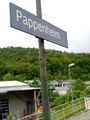
Pappenheim train station
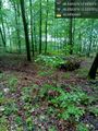
This decline could be tricky @48.9285,10.9557

Proof
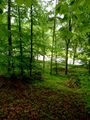
View from hash
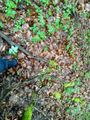
At the hash


Achievements
Torodeas earned the Land geohash achievement
|
Torodeas earned the Public transport geohash achievement
|