Difference between revisions of "2024-05-21 47 -122"
([live picture]Geohasher [https://openstreetmap.org/?mlat=47.25838730&mlon=-122.40234110&zoom=16 @47.2584,-122.4023]) |
m (Location correction) |
||
| (2 intermediate revisions by one other user not shown) | |||
| Line 1: | Line 1: | ||
| − | + | {{meetup graticule | |
| − | |||
| − | |||
| − | |||
| − | |||
| − | |||
| − | |||
| − | |||
| − | |||
| lat=47 | | lat=47 | ||
| lon=-122 | | lon=-122 | ||
| date=2024-05-21 | | date=2024-05-21 | ||
| + | | graticule_name=Seattle | ||
| + | | graticule_link=Seattle, Washington | ||
}}<!-- edit as necessary --> | }}<!-- edit as necessary --> | ||
== Location == | == Location == | ||
<!-- where you've surveyed the hash to be --> | <!-- where you've surveyed the hash to be --> | ||
| + | Outside a building in the industrial area of Tacoma waterfront | ||
== Participants == | == Participants == | ||
<!-- who attended: If you link to your wiki user name in this section, your expedition will be picked up by the various statistics generated for geohashing. You may use three tildes ~ as a shortcut to automatically insert the user signature of the account you are editing with. | <!-- who attended: If you link to your wiki user name in this section, your expedition will be picked up by the various statistics generated for geohashing. You may use three tildes ~ as a shortcut to automatically insert the user signature of the account you are editing with. | ||
--> | --> | ||
| + | * [[User:Thomcat|Thomcat]] | ||
== Plans == | == Plans == | ||
<!-- what were the original plans --> | <!-- what were the original plans --> | ||
| + | Only desire was discussed on discord. | ||
== Expedition == | == Expedition == | ||
<!-- how it all turned out. your narrative goes here. --> | <!-- how it all turned out. your narrative goes here. --> | ||
| + | Over here on the west coast of W30, we find out the Geohashing day point 6½ hours in, 5 out of 7 days. I was pretty excited to see what the options were, but not terribly available. Tacoma (not just a truck) is an hour south of here in light traffic - and a lot more in heavy. Perhaps a visit in the evening, after dinner and drinks? | ||
| + | |||
| + | May 21 was also a board meeting for the SD Card association, where I serve as the secretary. Not a job I can duck out on. However... the meeting went very quickly. In fact, by the time of our scheduled lunch break, we had completed our agenda. An afternoon free! Traffic maps showed the trip south taking just less than an hour. The trigger was pulled! | ||
| + | |||
| + | The trip south on the highway was fine, with an audio book (Valiant Ambition by Nathaniel Philbrick) to keep me company. Rain fell off and on, never heavy enough to be dangerous. Finally, the site was reached. This would *not* be a great trip via public transit, and the copious railroad tracks would make bicycling a challenge. Sometimes a car is just the best option - and today, the only option for me. | ||
| + | |||
| + | The point itself was easily danced, and I snapped a few photos. The trip back was uneventful, and I was able to return in time for the board of directors dinner. Would tomorrow's point be better? (Answer: no - it is in the water. Splash!) | ||
| + | |||
| + | This was my third geohashing day point - the first was 10 years previous in 2014. Looking forward to towel day / mouseover day. | ||
== Tracklog == | == Tracklog == | ||
| Line 35: | Line 41: | ||
Image:2024-05-21_47_-122_thomcat_1716329751087.jpg|Geohasher [https://openstreetmap.org/?mlat=47.25838730&mlon=-122.40234110&zoom=16 @47.2584,-122.4023] | Image:2024-05-21_47_-122_thomcat_1716329751087.jpg|Geohasher [https://openstreetmap.org/?mlat=47.25838730&mlon=-122.40234110&zoom=16 @47.2584,-122.4023] | ||
| + | |||
| + | Image:2024-05-21_47_-122_thomcat_1716329793865.jpg|Looking South [https://openstreetmap.org/?mlat=47.25840197&mlon=-122.40232397&zoom=16 @47.2584,-122.4023] | ||
</gallery> | </gallery> | ||
| Line 42: | Line 50: | ||
__NOTOC__ | __NOTOC__ | ||
| − | |||
| − | |||
| − | |||
| − | |||
| − | |||
| − | |||
| − | |||
| − | |||
| − | |||
| − | |||
[[Category:Expeditions]] | [[Category:Expeditions]] | ||
| − | |||
[[Category:Expeditions with photos]] | [[Category:Expeditions with photos]] | ||
| − | |||
| − | |||
| − | |||
| − | |||
[[Category:Coordinates reached]] | [[Category:Coordinates reached]] | ||
| − | + | {{location|US|WA|PI}} | |
| − | |||
| − | |||
| − | |||
| − | |||
| − | |||
| − | |||
| − | |||
| − | |||
| − | |||
| − | |||
| − | |||
| − | |||
Latest revision as of 03:52, 23 May 2024
| Tue 21 May 2024 in Seattle: 47.2583992, -122.4023303 geohashing.info google osm bing/os kml crox |
Location
Outside a building in the industrial area of Tacoma waterfront
Participants
Plans
Only desire was discussed on discord.
Expedition
Over here on the west coast of W30, we find out the Geohashing day point 6½ hours in, 5 out of 7 days. I was pretty excited to see what the options were, but not terribly available. Tacoma (not just a truck) is an hour south of here in light traffic - and a lot more in heavy. Perhaps a visit in the evening, after dinner and drinks?
May 21 was also a board meeting for the SD Card association, where I serve as the secretary. Not a job I can duck out on. However... the meeting went very quickly. In fact, by the time of our scheduled lunch break, we had completed our agenda. An afternoon free! Traffic maps showed the trip south taking just less than an hour. The trigger was pulled!
The trip south on the highway was fine, with an audio book (Valiant Ambition by Nathaniel Philbrick) to keep me company. Rain fell off and on, never heavy enough to be dangerous. Finally, the site was reached. This would *not* be a great trip via public transit, and the copious railroad tracks would make bicycling a challenge. Sometimes a car is just the best option - and today, the only option for me.
The point itself was easily danced, and I snapped a few photos. The trip back was uneventful, and I was able to return in time for the board of directors dinner. Would tomorrow's point be better? (Answer: no - it is in the water. Splash!)
This was my third geohashing day point - the first was 10 years previous in 2014. Looking forward to towel day / mouseover day.
Tracklog
Photos
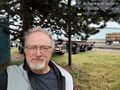
Geohasher @47.2584,-122.4023
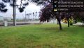
Looking South @47.2584,-122.4023

