Difference between revisions of "2024-06-03 47 -122"
([live picture]Geohasher [https://openstreetmap.org/?mlat=47.76513200&mlon=-122.11032697&zoom=16 @47.7651,-122.1103]) |
(Expedition success) |
||
| (2 intermediate revisions by the same user not shown) | |||
| Line 1: | Line 1: | ||
| − | + | {{meetup graticule | |
| + | | lat=47 | ||
| + | | lon=-122 | ||
| + | | date=2024-06-03 | ||
| + | | graticule_name=Seattle | ||
| + | | graticule_link=Seattle, Washington | ||
| + | }} | ||
| − | + | __NOTOC__ | |
| − | |||
| − | |||
| − | |||
| − | |||
| − | |||
| − | |||
== Location == | == Location == | ||
| − | + | The side of a street in Leota, just east of Woodinville. | |
== Participants == | == Participants == | ||
| − | + | * [[User:Thomcat|Thomcat]] | |
| − | |||
== Plans == | == Plans == | ||
| − | + | Fit in a visit around work, before driving completely the opposite direction for baseball. | |
== Expedition == | == Expedition == | ||
| − | + | Waiting for a colleague to show up and noticing it was near lunchtime, I decided to go for it. | |
| + | Roughly 10 miles round trip, and I wouldn't be walking, but should be able to make the visit in short order. | ||
| + | |||
| + | It was windy as heck all around Seattle, and many homes and businesses were without power. I passed many downed branches and a stoplight near Leota was completely black (treat as a all-way stop). This caused a bit of a traffic backup, which I would experience again on the way out of the neighborhood. | ||
| + | |||
| + | Other than the automotive GPS telling me to turn right now some 50 feet short of the road itself, the trip was uneventful. My survey of google aerial photo indicated I could probably park on the spot, and I did - my drivers seat drifted between 1 and 2 meters from the spot. I should probably get that fixed. | ||
| + | |||
| + | I wish I could have taken more time - a cool trail system was just north of the hashpoint. Trails named "Lushootseed Whispers", "Salish Songs" and curiously "Tinder Match". Where is "Swipe Right"? | ||
| + | |||
| + | On the way back, and past the still-blackened intersection, I found a local spot to grab some lunch - in this case, an 8 piece shrimp and chips. Tomorrow brings a flight to Detroit and hopefully a Michigan expedition - or at least on within walking distance of the Seattle airport terminal. | ||
== Tracklog == | == Tracklog == | ||
| − | <!-- if your GPS device keeps a log, you may | + | <!-- if your GPS device keeps a log, you may post a link here --> |
== Photos == | == Photos == | ||
| + | |||
<!-- Insert pictures between the gallery tags using the following format: | <!-- Insert pictures between the gallery tags using the following format: | ||
Image:2024-##-## ## ## Alpha.jpg | Witty Comment | Image:2024-##-## ## ## Alpha.jpg | Witty Comment | ||
| Line 31: | Line 40: | ||
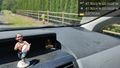
Image:2024-06-03_47_-122_thomcat_1717445119966.jpg|Geohasher [https://openstreetmap.org/?mlat=47.76513200&mlon=-122.11032697&zoom=16 @47.7651,-122.1103] | Image:2024-06-03_47_-122_thomcat_1717445119966.jpg|Geohasher [https://openstreetmap.org/?mlat=47.76513200&mlon=-122.11032697&zoom=16 @47.7651,-122.1103] | ||
| + | |||
| + | Image:2024-06-03_47_-122_thomcat_1717445183925.jpg|Window view [https://openstreetmap.org/?mlat=47.76513610&mlon=-122.11032860&zoom=16 @47.7651,-122.1103] | ||
| + | |||
| + | Image:2024-06-03_47_-122_thomcat_1717446061252.jpg|Lunch [https://openstreetmap.org/?mlat=47.76597900&mlon=-122.14817497&zoom=16 @47.7660,-122.1482] | ||
</gallery> | </gallery> | ||
| Line 38: | Line 51: | ||
__NOTOC__ | __NOTOC__ | ||
| − | |||
| − | |||
| − | |||
| − | |||
| − | |||
| − | |||
| − | |||
| − | |||
| − | |||
| − | |||
[[Category:Expeditions]] | [[Category:Expeditions]] | ||
| − | |||
[[Category:Expeditions with photos]] | [[Category:Expeditions with photos]] | ||
| − | |||
| − | |||
| − | |||
| − | |||
[[Category:Coordinates reached]] | [[Category:Coordinates reached]] | ||
| − | + | {{location|US|WA|KN}} | |
| − | |||
| − | |||
| − | |||
| − | |||
| − | |||
| − | |||
| − | |||
| − | |||
| − | |||
| − | |||
| − | |||
| − | |||
| − | |||
Latest revision as of 23:22, 3 June 2024
| Mon 3 Jun 2024 in Seattle: 47.7651490, -122.1103475 geohashing.info google osm bing/os kml crox |
Location
The side of a street in Leota, just east of Woodinville.
Participants
Plans
Fit in a visit around work, before driving completely the opposite direction for baseball.
Expedition
Waiting for a colleague to show up and noticing it was near lunchtime, I decided to go for it. Roughly 10 miles round trip, and I wouldn't be walking, but should be able to make the visit in short order.
It was windy as heck all around Seattle, and many homes and businesses were without power. I passed many downed branches and a stoplight near Leota was completely black (treat as a all-way stop). This caused a bit of a traffic backup, which I would experience again on the way out of the neighborhood.
Other than the automotive GPS telling me to turn right now some 50 feet short of the road itself, the trip was uneventful. My survey of google aerial photo indicated I could probably park on the spot, and I did - my drivers seat drifted between 1 and 2 meters from the spot. I should probably get that fixed.
I wish I could have taken more time - a cool trail system was just north of the hashpoint. Trails named "Lushootseed Whispers", "Salish Songs" and curiously "Tinder Match". Where is "Swipe Right"?
On the way back, and past the still-blackened intersection, I found a local spot to grab some lunch - in this case, an 8 piece shrimp and chips. Tomorrow brings a flight to Detroit and hopefully a Michigan expedition - or at least on within walking distance of the Seattle airport terminal.
Tracklog
Photos

Geohasher @47.7651,-122.1103
Window view @47.7651,-122.1103
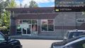
Lunch @47.7660,-122.1482


