Difference between revisions of "2024-07-03 45 -122"
([retro picture]Gravestone) |
Michael5000 (talk | contribs) (→Expedition 2: Michael5000) |
||
| (12 intermediate revisions by 3 users not shown) | |||
| Line 1: | Line 1: | ||
| − | + | [[Image:{{{image|2024-07-03 45 -122 frogman 1720105083831.jpg}}}|thumb|left]]{{meetup graticule|date=2024-07-03|lat=45|lon=-122}} | |
| − | |||
| − | [[Image:{{{image| | ||
| − | |||
| − | |||
| − | |||
| − | |||
| − | |||
| − | |||
== Location == | == Location == | ||
| − | + | At the intersection of Sandy and NE 122nd. | |
== Participants == | == Participants == | ||
| − | + | *[[User:Frogman|Frogman]] | |
| − | + | *[[User:Higgs|Higgs]] | |
| + | *[[User:Michael5000|Michael5000]] | ||
== Plans == | == Plans == | ||
| − | < | + | <code>June 3rd, 9:55am [[User:Frogman|Frogman]] wrote: Geohashing today? |
| + | |||
| + | June 3rd, 11:03am [[User:Michael5000|Michael5000]] wrote: Think probably so</code> | ||
== Expedition == | == Expedition == | ||
| − | + | ===Expedition 1: [[User:Frogman|Frogman]] and [[User:Higgs|Higgs]]=== | |
| + | [[User:Higgs|Higgs]] and I headed out after work. We took public transit: the MAX Green Line to Gateway and then the 22 bus most of the rest of the way. The MAX we caught was a single train car, which I've observed is more common recently — I wonder why? | ||
| + | |||
| + | After disembarking in a nearby residential neighborhood, we walked north to Sandy and met a man who was out for a stroll. He asked us for directions to the Round Table pizza on 122nd Avenue. Having just came from there on the bus (and being somewhat familiar with the area from previous trips) we confidently sent him on his way. A minute or so more of walking found us at the hashpoint. We snapped a couple of pictures, including of the nearby fire training building. "There's that tower that they light on fire for fun sometimes," I said. "I don't think they do it for fun," replied [[User:Higgs|Higgs]], "they do it for training. It's probably not very fun at all." | ||
| + | |||
| + | We had planned to meet [[User:Michael5000|Michael5000]] at the hashpoint, but it was sunny and hot, so we walked over to a nearby grove of trees to stay cool while we waited. As we approached, we realized that the grove contained a small cemetery! We were intrigued by the age of the graves and found some of the names familiar: Powell, Reynolds, and Wilkes stood out as the possible namesakes of things in the area. After doing a bit of research, here are my findings: | ||
| + | * Powell Boulevard is named after Jackson Powell, who had a farm in Gresham. Jackson himself appears to be buried in [https://www.findagrave.com/memorial/66174140/jackson-powell Gresham Pioneer Cemetary]. Are these Powells related to him? It's unclear, but here's a clue: both Jackson and this cemetery's patriarch [https://www.findagrave.com/memorial/6414684/david_powell David] were born around the same time in Kentucky. Brothers, perhaps? | ||
| + | * Reynolds High School was named after the former Reynolds Aluminum plant. Were these Reynoldses related to the famed metal magnates? There's another Kentucky connection here: Reynolds Metals Company was founded in Louisville. This is pretty tenuous, though, so I think a link is unlikely. | ||
| + | * William G. and Sarah Ann Wilkes did, indeed, donate the land on which [https://www.reynolds.k12.or.us/wilkes/welcome-wilkes-elementary Wilkes Elementary School] sits! I attended school there from the 2nd grade onwards, so it was cool to see this connection. Although William's grave is very clearly marked, I couldn't find Sarah's (and neither can [https://www.findagrave.com/memorial/147033798/sarah-ann-wilkes Find-A-Grave], but note that they dispute the elementary school's assertion that William and Sarah were siblings). | ||
| + | |||
| + | As we were looking at the graves, [[User:Michael5000|Michael5000]] rode up on his bike. We headed back to the hashpoint to get a group photo. | ||
| + | |||
| + | We stood around a bit and chatted, and the man from earlier walked by. Did he make it to his destination? we asked. Yes, he replied, but our directions through the residential neighborhood were 0.1 miles longer than simply taking Sandy and 122nd. We pointed out that the route we suggested was a lot more pleasant a pedestrian experience. He agreed. | ||
| + | |||
| + | ===Expedition 2: [[User:Michael5000|Michael5000]]=== | ||
| − | + | I rode up on my bike. Then, after some catching up, rode home via the Columbia River trail. Expedition 2 was lighter on local history. | |
| − | |||
== Photos == | == Photos == | ||
| Line 43: | Line 51: | ||
Image:2024-07-03_45_-122_frogman_1720105110627.jpg|Gravestone | Image:2024-07-03_45_-122_frogman_1720105110627.jpg|Gravestone | ||
| + | |||
| + | Image:2024-07-03_45_-122_frogman_1720105128902.jpg|Gravestone | ||
| + | |||
| + | Image:2024-07-03_45_-122_frogman_1720105138979.jpg|Gravestone | ||
| + | |||
| + | Image:2024-07-03_45_-122_frogman_1720105180036.jpg|Gravestone. Hey, I've heard of this guy! | ||
| + | |||
| + | Image:2024-07-03_45_-122_frogman_1720105255791.jpg|Gravestone. Is this the correct S. Wilkes? | ||
| + | |||
| + | Image:2024-07-03_45_-122_frogman_1720105270094.jpg|Nearby construction area. | ||
| + | |||
| + | Image:2024-07-03_45_-122_frogman_1720105289978.jpg|Michael trying to get his GPS to cooperate. | ||
| + | |||
| + | Image:2024-07-03_45_-122_frogman_1720105305919.jpg|A passing freight train. | ||
| + | |||
| + | File:2024-07-03 45 -122 e.jpg|And then there were three. | ||
</gallery> | </gallery> | ||
== Achievements == | == Achievements == | ||
| − | {{ | + | {{Public transport geohash |
| − | + | ||
| + | | latitude = 45 | ||
| + | | longitude = -122 | ||
| + | | date = 2024-07-03 | ||
| + | | busline = Trimet | ||
| + | | name = [[User:Frogman|Frogman]] and [[User:Higgs|Higgs]] | ||
| + | | image = 2024-07-03 45 -122 frogman 1720105003920.jpg | ||
| + | |||
| + | }} | ||
| + | |||
| + | {{bicycle geohash | ||
| − | + | | latitude = 45 | |
| − | + | | longitude = -122 | |
| − | + | | date = 2024-07-03 | |
| − | [[ | + | | name = [[user:Michael5000|Michael5000]] |
| + | | distance = 21.9 miles | ||
| + | | bothways = true (optional) | ||
| − | + | }} | |
| − | |||
| − | |||
| − | |||
| − | |||
[[Category:Expeditions]] | [[Category:Expeditions]] | ||
| − | |||
[[Category:Expeditions with photos]] | [[Category:Expeditions with photos]] | ||
| − | |||
| − | |||
| − | |||
| − | |||
[[Category:Coordinates reached]] | [[Category:Coordinates reached]] | ||
| − | + | {{location|US|OR|MU}} | |
| − | |||
| − | |||
| − | |||
| − | |||
| − | |||
| − | |||
| − | |||
| − | |||
| − | |||
| − | |||
| − | |||
| − | |||
| − | |||
Latest revision as of 17:12, 4 July 2024

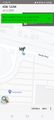
| Wed 3 Jul 2024 in 45,-122: 45.5568557, -122.5359995 geohashing.info google osm bing/os kml crox |
Contents
Location
At the intersection of Sandy and NE 122nd.
Participants
Plans
June 3rd, 9:55am Frogman wrote: Geohashing today?
June 3rd, 11:03am Michael5000 wrote: Think probably so
Expedition
Expedition 1: Frogman and Higgs
Higgs and I headed out after work. We took public transit: the MAX Green Line to Gateway and then the 22 bus most of the rest of the way. The MAX we caught was a single train car, which I've observed is more common recently — I wonder why?
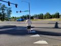
After disembarking in a nearby residential neighborhood, we walked north to Sandy and met a man who was out for a stroll. He asked us for directions to the Round Table pizza on 122nd Avenue. Having just came from there on the bus (and being somewhat familiar with the area from previous trips) we confidently sent him on his way. A minute or so more of walking found us at the hashpoint. We snapped a couple of pictures, including of the nearby fire training building. "There's that tower that they light on fire for fun sometimes," I said. "I don't think they do it for fun," replied Higgs, "they do it for training. It's probably not very fun at all."
We had planned to meet Michael5000 at the hashpoint, but it was sunny and hot, so we walked over to a nearby grove of trees to stay cool while we waited. As we approached, we realized that the grove contained a small cemetery! We were intrigued by the age of the graves and found some of the names familiar: Powell, Reynolds, and Wilkes stood out as the possible namesakes of things in the area. After doing a bit of research, here are my findings:
- Powell Boulevard is named after Jackson Powell, who had a farm in Gresham. Jackson himself appears to be buried in Gresham Pioneer Cemetary. Are these Powells related to him? It's unclear, but here's a clue: both Jackson and this cemetery's patriarch David were born around the same time in Kentucky. Brothers, perhaps?
- Reynolds High School was named after the former Reynolds Aluminum plant. Were these Reynoldses related to the famed metal magnates? There's another Kentucky connection here: Reynolds Metals Company was founded in Louisville. This is pretty tenuous, though, so I think a link is unlikely.
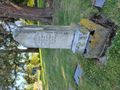
- William G. and Sarah Ann Wilkes did, indeed, donate the land on which Wilkes Elementary School sits! I attended school there from the 2nd grade onwards, so it was cool to see this connection. Although William's grave is very clearly marked, I couldn't find Sarah's (and neither can Find-A-Grave, but note that they dispute the elementary school's assertion that William and Sarah were siblings).
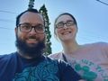
As we were looking at the graves, Michael5000 rode up on his bike. We headed back to the hashpoint to get a group photo.
We stood around a bit and chatted, and the man from earlier walked by. Did he make it to his destination? we asked. Yes, he replied, but our directions through the residential neighborhood were 0.1 miles longer than simply taking Sandy and 122nd. We pointed out that the route we suggested was a lot more pleasant a pedestrian experience. He agreed.
Expedition 2: Michael5000
I rode up on my bike. Then, after some catching up, rode home via the Columbia River trail. Expedition 2 was lighter on local history.
Photos
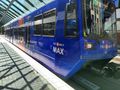
Here comes the MAX!
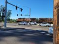
Waiting for the bus at Gateway.
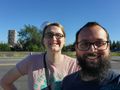
Proof that we have arrived!
The geohashers from Expedition 1.
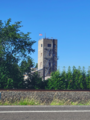
Nearby fire training building.
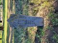
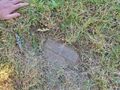
Gravestone
Gravestone
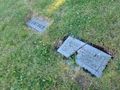
Gravestone
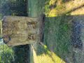
Gravestone
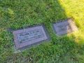
Gravestone. Hey, I've heard of this guy!
Gravestone. Is this the correct S. Wilkes?
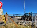
Nearby construction area.
Michael trying to get his GPS to cooperate.
A passing freight train.
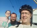
And then there were three.


Achievements
Frogman and Higgs earned the Public transport geohash achievement
|
Michael5000 earned the Bicycle geohash achievement
|