2024-09-19 56 -3
| Thu 19 Sep 2024 in 56,-3: 56.0845834, -3.9511244 geohashing.info google osm bing/os kml crox |
Contents
Location
In a field near Bannockburn.
Participants
Plans
KerrMcF
It's beginning to feel a little bit silly to me with how many geohashes I've done in a row. Before this, my longest streak was 2, but this one will bring me to 6. I've not got anything to do on this date, so I'm not sure exactly when I'll carry out these plans. I'll drive to the nearby Battle of Bannockburn Visitor Centre and park there. I'll probably have a look around the museum for a while - I've definitely been before, but it was a while ago - before walking in the direction of the field. I'm hoping the field will be accessible, it's difficult to tell from street-level and satellite imagery. If not immediately apparent, I can ask the house next to the field. There's a nearby geocache, almost certainly visible from the geohash itself (based on street-level imagery), so I'll try to get this too.
Expedition
KerrMcF
I began this expedition by driving to the Battle of Bannockburn Visitor Centre, which took about 45 minutes. I went inside to have a quick look around before setting off towards the geohash. The walk was along a minor road the whole way, and it took about 15 minutes to reach the field containing the geohash. The usage of the field had thankfully seemingly changed since the street-level imagery had been taken, and it was now home to three sheep. This meant I would be able to enter it with no issues. I did so, and found the geohash successfully.
Whilst I was taking my photos at the geohash, a car drove past me. Based on the road layout, I have to assume this car belonged to the owner of the field, who was probably wondering what I was doing in their field. It is, of course, legal for me to be in that field, but it must've looked a little strange. I left by climbing over the same gate I had used to enter and began heading to the location of the nearby geocache. It didn't take long to get there, and I was able to find the cache pretty quickly. I signed the logbook as KerrMcF and put the cache back where I had found it. I also took a photo showing that it was within sight of the geohash before walking back towards the car.
After a small detour in the car for reasons I will not yet disclose but are pertinent to the expedition, I began the drive home. This took another hour or so, giving a total expedition time of around 3 hours. I recently said to myself that I wouldn't be creating any more A Tale of Two Hashes challenges, because the ribbon system with that achievement is a little difficult to navigate, but something caused me to re-evaluate that for this geohash. Challenge for Bannockburn created. This was my 32nd expedition, so I've unlocked level 5 of the Two to the N achievement. It was also my sixth consecutive success. Click for 2024-09-14 56 -3; 2024-09-15 55 -3; 2024-09-16 56 -4; 2024-09-17 55 -4; or 2024-09-18 55 -4.
Photos
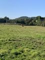
Some cows watching me
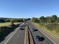
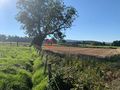
Over the motorway
Reached the geohash
Zoomed out view
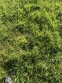
The geohash itself

Me at the geohash
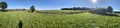
Panorama from the geohash
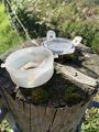
The nearby geocache
The geohash as seen from the geocache
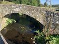
Bridge over the actual Bannock Burn
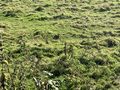
A rabbit watching me
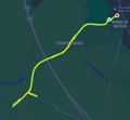
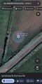
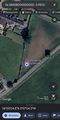
The route I walked


Achievements
KerrMcF earned the Land geohash achievement
|
KerrMcF earned the Hash collision achievement
|


KerrMcF earned the Consecutive geohash achievement
|
Progress
| Council Area | Postcode | NUTS | Centicule |
|---|---|---|---|
| Stirling | FK(7) | UKM77 | 09 |
| Expedition Navigation | ||
|---|---|---|
| KerrMcF's expeditions | No Next Yet | |
- Meetup on 2024-09-19
- Meetup in 56 -3
- Meetup in Stirling
- Expeditions by KerrMcF
- KerrMcF's expeditions by car
- KerrMcF's expeditions on foot
- Land geohash achievement
- Hash collision achievement
- A Tale of Two Hashes challenge
- Two to the N achievement
- Consecutive geohash achievement
- Expeditions
- Coordinates reached
- Expeditions with photos