Difference between revisions of "2008-10-07 55 -120"
imported>Robyn (Dawson Creek airhash reached. Damn this hotel internet is SLOW!) |
imported>Robyn (Mistyped image name) |
||
| Line 9: | Line 9: | ||
After nailing the [[2008-10-07 54 -119|Nose Creek]] geohash, I reset the GPS to check out [[Dawson Creek, British Columbia|Dawson Creek]], the next graticule northwest. It wasn't exactly in line with my track, and I was zig-zagging for weather anyway, so I ignored it for a while, the weather was closing in and I had to choose a good route. | After nailing the [[2008-10-07 54 -119|Nose Creek]] geohash, I reset the GPS to check out [[Dawson Creek, British Columbia|Dawson Creek]], the next graticule northwest. It wasn't exactly in line with my track, and I was zig-zagging for weather anyway, so I ignored it for a while, the weather was closing in and I had to choose a good route. | ||
| + | {{meetup graticule | ||
| + | | map=<map lat="55" lon="-120" date="2008-10-07" /> | ||
| + | | lat=55 | ||
| + | | lon=-120 | ||
| + | | date=2008-10-07 | ||
| + | }} | ||
| + | ==Location== | ||
| + | By a river in the middle of nowhere. | ||
| + | ==Participants== | ||
| + | Just [[User:Robyn|Robyn]] again | ||
==Expedition== | ==Expedition== | ||
I flew a heading to go around some of the weather, and when I turned back on course the XKCD waypoint was sitting there in front of me, just asking to be flown to. How could I deny it? Not too much to say here. Air hashes can be kind of boring. You can see from the picture that the clouds are getting lower, and it's raining a bit. I'm afraid I can't match anything from the picture to the satellite shot, except maybe a loop of that river. | I flew a heading to go around some of the weather, and when I turned back on course the XKCD waypoint was sitting there in front of me, just asking to be flown to. How could I deny it? Not too much to say here. Air hashes can be kind of boring. You can see from the picture that the clouds are getting lower, and it's raining a bit. I'm afraid I can't match anything from the picture to the satellite shot, except maybe a loop of that river. | ||
| Line 16: | Line 26: | ||
<gallery> | <gallery> | ||
Image:2008-10-07 55-120.view.JPG|Rain, cloud, mist, and a geohash out there somewhere. | Image:2008-10-07 55-120.view.JPG|Rain, cloud, mist, and a geohash out there somewhere. | ||
| − | Image:2008-10-07 55-120 | + | Image:2008-10-07 55-120.JPG|Within the prescribed ten arc seconds of the dsignated point. |
</gallery> | </gallery> | ||
Revision as of 02:41, 8 October 2008
| Tue 7 Oct 2008 in 55,-120: 55.5568742, -120.4033689 geohashing.info google osm bing/os kml crox |
Contents
Set Up
After nailing the Nose Creek geohash, I reset the GPS to check out Dawson Creek, the next graticule northwest. It wasn't exactly in line with my track, and I was zig-zagging for weather anyway, so I ignored it for a while, the weather was closing in and I had to choose a good route.
| Tue 7 Oct 2008 in 55,-120: 55.5568742, -120.4033689 geohashing.info google osm bing/os kml crox |
Location
By a river in the middle of nowhere.
Participants
Just Robyn again
Expedition
I flew a heading to go around some of the weather, and when I turned back on course the XKCD waypoint was sitting there in front of me, just asking to be flown to. How could I deny it? Not too much to say here. Air hashes can be kind of boring. You can see from the picture that the clouds are getting lower, and it's raining a bit. I'm afraid I can't match anything from the picture to the satellite shot, except maybe a loop of that river.
It started snowing shortly after that, but I had put the camera away to focus on my job. I did reset the GPS for yet another try further northeast.
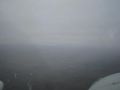
Rain, cloud, mist, and a geohash out there somewhere.
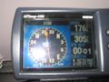
Within the prescribed ten arc seconds of the dsignated point.

