Difference between revisions of "2009-05-03 67 20"
From Geohashing
imported>The ru |
imported>The ru |
||
| Line 23: | Line 23: | ||
Image:2009-05-03_67_20_hashpoint.jpg | The hashpoint | Image:2009-05-03_67_20_hashpoint.jpg | The hashpoint | ||
Image:2009-05-03_67_20_gps.jpg | GPS | Image:2009-05-03_67_20_gps.jpg | GPS | ||
| − | Image:2009-05-03_67_20_cable.jpg | I found this electrical cable attached to a pole. It led into conduit under the road, I found it coming out on the other side, but it didn't lead anywhere!? | + | Image:2009-05-03_67_20_cable.jpg | I found this electrical cable attached to a pole. It led into a conduit under the road, I found it coming out on the other side, but it didn't lead anywhere!? |
Image:2009-05-03_67_20_sign.jpg | Obviously, this is the second of something (kilometer, probably) | Image:2009-05-03_67_20_sign.jpg | Obviously, this is the second of something (kilometer, probably) | ||
Image:2009-05-03_67_20_water.jpg | | Image:2009-05-03_67_20_water.jpg | | ||
Revision as of 16:09, 3 May 2009
| Sun 3 May 2009 in 67,20: 67.8703338, 20.5135538 geohashing.info google osm bing/os kml crox |
The hashpoint was next to the Kallovaara road, north of Laxforsen.
the ru
This was within walking distance for me, but my hiking boots were still wet from other spontaneous adventures, so I decided to drive to the hashpoint instead.
the ru has visited an Easy Geohash
|
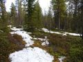
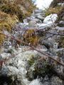
The hashpoint
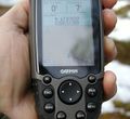
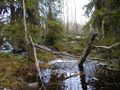
GPS
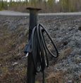
I found this electrical cable attached to a pole. It led into a conduit under the road, I found it coming out on the other side, but it didn't lead anywhere!?
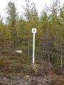
Obviously, this is the second of something (kilometer, probably)
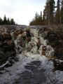
Miniature waterfall
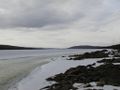
Torne river, still frozen


