Difference between revisions of "2009-05-12 49 -123"
From Geohashing
imported>Rhonda (+Rhonda's photos) |
imported>Robyn (tracklog & notes on it) |
||
| Line 31: | Line 31: | ||
===Up the hill=== | ===Up the hill=== | ||
===Home=== | ===Home=== | ||
| + | |||
| + | ==GPS Tracklog== | ||
| + | Look at the [http://www.everytrail.com/view_trip.php?trip_id=206609 tracklog] to see ... | ||
| + | |||
| + | *how far we drifted sideways when we stopped to rest (you can see one rest each way, at about the same point) | ||
| + | *our tracks turning into the waves as we neared the point and the waves got strong enough to swamp us | ||
| + | *the zigzags about 30 m from the geohash as I tried to hold my position while getting out a compass in the waves | ||
| + | *multiple attempts to pass through the geohash with my camera ready | ||
| + | *higher speed on the way home | ||
| + | *greater drift on the return leg from higher winds and the incoming tide | ||
| + | *proof that we did reach the geohash, even if we couldn't photograph it | ||
| + | |||
===Kayak to-do list=== | ===Kayak to-do list=== | ||
*comfort handle for case | *comfort handle for case | ||
Revision as of 19:56, 13 May 2009
It's a transit-kayak hash.
| Tue 12 May 2009 in 49,-123: 49.4571520, -123.2901707 geohashing.info google osm bing/os kml crox |
Contents
Location
In Howe Sound, directly between Lions Bay and Gambier Island, 3.65 km offshore.
Planning
- The 257 Horseshoe Bay Express bus leaves from Burrard & Georgia approximately every half hour.
- Transfer from Marine Drive and Nelson (just before the ferry terminal) to a C12 Lions Bay (leaving every hour, so that's the bottleneck).
- Walk to beach.
- Inflate and launch kayak.
- The low tide at Point Atkinson and Squamish is 14:15, so it will be close to turning and not a strong cross-current
- A strong wind warning is issued for Howe Sound. It's 11 kts now, and the forecast is 15 to 25 knots near noon, then diminishing so what we see when we get there we expect to diminish. I think we'd be kind of sheltered by Bowen & Gambier, as well.
Participants
Expedition
Robyn
Rhonda
C12 Shuttle
Launch
To the geohash
Back to the beach
Packing the kayaks
Up the hill
Home
GPS Tracklog
Look at the tracklog to see ...
- how far we drifted sideways when we stopped to rest (you can see one rest each way, at about the same point)
- our tracks turning into the waves as we neared the point and the waves got strong enough to swamp us
- the zigzags about 30 m from the geohash as I tried to hold my position while getting out a compass in the waves
- multiple attempts to pass through the geohash with my camera ready
- higher speed on the way home
- greater drift on the return leg from higher winds and the incoming tide
- proof that we did reach the geohash, even if we couldn't photograph it
Kayak to-do list
- comfort handle for case
- wheels for case?
- waterproofing for spray skirt
- waterproof bag to go inside rear compartment
- some way to keep deflator from getting lost
- velcro for spray skirt?
Photos
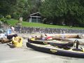
A nice sandy beach to launch from
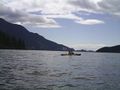
Under way
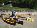
Deflating and drying
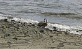
Visitors


