Difference between revisions of "2009-05-12 49 -123"
imported>Robyn (+Robyn) |
imported>Robyn (intermediate save) |
||
| Line 35: | Line 35: | ||
The bus driver didn't comment on my luggage or deny me boarding for carrying something the size of a suitcase, plus paddles, although I did get some double-takes from passengers. "Is that actually a ''kayak?''" | The bus driver didn't comment on my luggage or deny me boarding for carrying something the size of a suitcase, plus paddles, although I did get some double-takes from passengers. "Is that actually a ''kayak?''" | ||
| − | ===C12 | + | ===Getting to the water=== |
| + | At Horseshoe Bay we bought some sandwiches and waited at the sign for the C12 shuttle. We spotted it approaching and then flagged it down as it almost went by. We may not have been in quite the right place, but the driver didn't mind where we got on. There were no other passengers or stops so we were soon in Lions Bay where the driver stopped under an overpass and pointed out the best way down to the beach. The kayaks are in bags, but they are still heavy and awkward to carry. | ||
| + | |||
| + | When we reached a fork in the road, Robyn left her kayak with Rhonda and went down the left fork to see if there were boat launching facilities there. There were, at $6 each for kayaks and the woman smiled as she replied in the affirmative when Robyn asked if the other road led to a beach where they could launch their kayaks for free. We took the left fork and were soon at a sandy beach where we could assemble and launch our craft. Rhonda's was pumped up and ready to go six minutes from setting down the bag on the beach. Robyn's pump wasn't quite as good, so hers took a few minutes longer. | ||
| + | |||
| + | We sorted out what we needed with us and what we needed when we got back and stashed the latter in the kayak bags under a boat stored on the shore. The water looked great. | ||
| + | |||
| + | ===Getting ''in'' the water=== | ||
| + | Our previous launch of these kayaks was from a boat ramp, and the time before that Robyn launched from a dock. Launching off a beach is a little more challenging, especially when there are barnacle-encrusted rocks on the beach. There weren't many, it was mainly sand, but as this was a very low tide there were rocks exposed at the water's edge. We walked down and inspected to see that they didn't get much more numerous. | ||
| + | |||
| + | Robyn envisioned a launch technique kind of like a surfboard where you get in the water, give the kayal a good push to get it off the shore, leap in and paddle away from the shore and then get organized once you are clear of the surf. She explained this to Rhonda, but having become used to Rhonda thinking the same thing as her, didn't use enough words. As Rhonda waded in beside the kayak and Robyn prepared to push off, Rhonda didn't leap boldly in the kayak and the waves pushed it around sideways. They pulled the kayak back on the beach and Robyn explained her scheme properly, the way you have to to someone who doesn't actually share the same brain. We tried it again and this time it worked. It even worked for Robyn who didn't have someone else to push her off, she just pushed and leaped and paddled and then sat in the nice warm comfy kayak to work out what had happened to her seat, organize her spray skirt, and point in the right direction. | ||
| + | |||
| + | ===Paddling to the geohash and back=== | ||
| + | The water was glorious and there were smooth rolling waves to paddle over in an environment hardly changed in the couple of hundred years since Europeans first saw this place. People have probably been launching canoes off that beach for a thousand years, in order to paddle to Gambier Island or to fish here in Howe Sound. "Where's that 'strong wind'?" asked Rhonda, mocking the forecast. We probably should have known better than that. Robyn expected that there would be more wind after we got out of the shadow of Bowen Island, but the wind was supposed to be subsiding at this point, and we hadn't seen any whitecaps from the highway. We enjoyed paddling. | ||
| + | |||
| + | After about half an hour we took a snack break and then continued. The wind was picking up a bit and the tide was turning to come back in. We were making three to four km/h over the water until the last 250 metres to the geohash when the wind really picked up and it was necessary to turn directly into the waves to stay safe from being swamped by the waves. We were working just to stay in one place. We regrouped and paddled hard into the waves when the wind gusted and across when it subsided, to reach the geohash. About 30 metres away we got ready to photograph it, but the wind swept us away again, so we paddled past it and tried to get it on the way back. The problem was that to control a kayak you need both hands on the paddle, but to get out a camera you have to put down the paddle, open the spray skirt, get out the camera and take the picture, all without getting drenched. We made a couple of tries but decided that it was best to just let the tracklog be our proof, and ride the wind home. | ||
| + | |||
| + | It was easier paddling with the wind somewhat behind us, but it was still a crosswind and we had to be attentive. You can see how much we drifted sideways during a snack break on the way back. The wind direction had shifted slightly so that Bowen island no longer protected us, and the waves stayed big almost all the way to the beach. Most of the time the flexible little kayaks rode over the waves, or they broke on the bow or stern, but we got one each full in the face wave, and were glad we weren't facing that at every paddle stroke. | ||
| + | |||
| + | ===Getting '''out''' of the water=== | ||
| + | |||
| + | Rhonda | ||
| + | |||
===Launch=== | ===Launch=== | ||
===To the geohash=== | ===To the geohash=== | ||
Revision as of 04:23, 14 May 2009
It's a transit-kayak hash.
| Tue 12 May 2009 in 49,-123: 49.4571520, -123.2901707 geohashing.info google osm bing/os kml crox |
Location
In Howe Sound, directly between Lions Bay and Gambier Island, 3.65 km offshore.
Planning
- The 257 Horseshoe Bay Express bus leaves from Burrard & Georgia approximately every half hour.
- Transfer from Marine Drive and Nelson (just before the ferry terminal) to a C12 Lions Bay (leaving every hour, so that's the bottleneck).
- Walk to beach.
- Inflate and launch kayak.
- The low tide at Point Atkinson and Squamish is 14:15, so it will be close to turning and not a strong cross-current
- A strong wind warning is issued for Howe Sound. It's 11 kts now, and the forecast is 15 to 25 knots near noon, then diminishing so what we see when we get there we expect to diminish. I think we'd be kind of sheltered by Bowen & Gambier, as well.
Participants
Expedition
Robyn
I had been longing for a transit-kayak hash for a while and the beautiful thing about geohashing is that if it can happen in your graticule, sooner or later the algorithm gives it to you. When I saw the coordinates I looked up the bus schedule, the tide tables and the weather forecast. Environment Canada had issued a strong wind warning, but not anything worse than on our previous kayak trip, and they were supposed to subside after noon. I thought it was a go.
My greatest trepidation was not weather but buses. I had to take three buses to reach the geohash. Would one of the drivers refuse my carry on item? Who takes a boat on a bus? But the first bus driver didn't blink at it and nor did the next one, even when Rhonda got on and added a second kayak to the bus.
Rhonda
I was attempting to get chores done before checking the day's hash point, but I checked email instead and got a page changed notification about an accessible point for the day...
A quick check of the translink schedules, two trips to drop off my bike at the bike store for its new rear wheel (the first trip was an hour before they opened for the day), and a vote cast in the provincial election later, I had done the time-critical chores and was packed and ready to catch the bus with my kayak over one shoulder and my paddle in the other hand. I made it to the bus stop in plenty of time to catch the bus for Park Royal, where I would transfer to the Horseshoe Bay express.
The bus driver didn't comment on my luggage or deny me boarding for carrying something the size of a suitcase, plus paddles, although I did get some double-takes from passengers. "Is that actually a kayak?"
Getting to the water
At Horseshoe Bay we bought some sandwiches and waited at the sign for the C12 shuttle. We spotted it approaching and then flagged it down as it almost went by. We may not have been in quite the right place, but the driver didn't mind where we got on. There were no other passengers or stops so we were soon in Lions Bay where the driver stopped under an overpass and pointed out the best way down to the beach. The kayaks are in bags, but they are still heavy and awkward to carry.
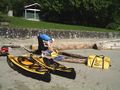
When we reached a fork in the road, Robyn left her kayak with Rhonda and went down the left fork to see if there were boat launching facilities there. There were, at $6 each for kayaks and the woman smiled as she replied in the affirmative when Robyn asked if the other road led to a beach where they could launch their kayaks for free. We took the left fork and were soon at a sandy beach where we could assemble and launch our craft. Rhonda's was pumped up and ready to go six minutes from setting down the bag on the beach. Robyn's pump wasn't quite as good, so hers took a few minutes longer.
We sorted out what we needed with us and what we needed when we got back and stashed the latter in the kayak bags under a boat stored on the shore. The water looked great.
Getting in the water
Our previous launch of these kayaks was from a boat ramp, and the time before that Robyn launched from a dock. Launching off a beach is a little more challenging, especially when there are barnacle-encrusted rocks on the beach. There weren't many, it was mainly sand, but as this was a very low tide there were rocks exposed at the water's edge. We walked down and inspected to see that they didn't get much more numerous.
Robyn envisioned a launch technique kind of like a surfboard where you get in the water, give the kayal a good push to get it off the shore, leap in and paddle away from the shore and then get organized once you are clear of the surf. She explained this to Rhonda, but having become used to Rhonda thinking the same thing as her, didn't use enough words. As Rhonda waded in beside the kayak and Robyn prepared to push off, Rhonda didn't leap boldly in the kayak and the waves pushed it around sideways. They pulled the kayak back on the beach and Robyn explained her scheme properly, the way you have to to someone who doesn't actually share the same brain. We tried it again and this time it worked. It even worked for Robyn who didn't have someone else to push her off, she just pushed and leaped and paddled and then sat in the nice warm comfy kayak to work out what had happened to her seat, organize her spray skirt, and point in the right direction.
Paddling to the geohash and back
The water was glorious and there were smooth rolling waves to paddle over in an environment hardly changed in the couple of hundred years since Europeans first saw this place. People have probably been launching canoes off that beach for a thousand years, in order to paddle to Gambier Island or to fish here in Howe Sound. "Where's that 'strong wind'?" asked Rhonda, mocking the forecast. We probably should have known better than that. Robyn expected that there would be more wind after we got out of the shadow of Bowen Island, but the wind was supposed to be subsiding at this point, and we hadn't seen any whitecaps from the highway. We enjoyed paddling.
After about half an hour we took a snack break and then continued. The wind was picking up a bit and the tide was turning to come back in. We were making three to four km/h over the water until the last 250 metres to the geohash when the wind really picked up and it was necessary to turn directly into the waves to stay safe from being swamped by the waves. We were working just to stay in one place. We regrouped and paddled hard into the waves when the wind gusted and across when it subsided, to reach the geohash. About 30 metres away we got ready to photograph it, but the wind swept us away again, so we paddled past it and tried to get it on the way back. The problem was that to control a kayak you need both hands on the paddle, but to get out a camera you have to put down the paddle, open the spray skirt, get out the camera and take the picture, all without getting drenched. We made a couple of tries but decided that it was best to just let the tracklog be our proof, and ride the wind home.
It was easier paddling with the wind somewhat behind us, but it was still a crosswind and we had to be attentive. You can see how much we drifted sideways during a snack break on the way back. The wind direction had shifted slightly so that Bowen island no longer protected us, and the waves stayed big almost all the way to the beach. Most of the time the flexible little kayaks rode over the waves, or they broke on the bow or stern, but we got one each full in the face wave, and were glad we weren't facing that at every paddle stroke.
Getting out of the water
Rhonda
Launch
To the geohash
Back to the beach
Packing the kayaks
Up the hill
Home
Epilogue
GPS Tracklog
Look at the tracklog to see ...
- how far we drifted sideways when we stopped to rest (you can see one rest each way, at about the same point)
- our tracks turning into the waves as we neared the point and the waves got strong enough to swamp us
- the zigzags about 30 m from the geohash as I tried to hold my position while getting out a compass in the waves
- multiple attempts to pass through the geohash with my camera ready
- higher speed on the way home
- greater drift on the return leg from higher winds and the incoming tide
- proof that we did reach the geohash, even if we couldn't photograph it
Reported winds
Weather from Pam Rocks weather station, in Howe Sound, just north of us. Wind speeds are reported in knots (nautical miles per hour). Double the numbers for an estimate of wind speed in km/hr (1.852 km per nautical mile)
| Time | Winds from | Kayak bearing |
|---|---|---|
| 13:00 | S 16 | launch 13:45 |
| 14:00 | S 14 | W |
| 15:00 | S 17 | turning around ~15:15 |
| 16:00 | S 15 | E - landed ~16:30 |
| 17:00 | SSE 15G20 |
Kayak to-do list
- comfort handle for case
- wheels for case?
- waterproofing for spray skirt
- waterproof bag to go inside rear compartment
- some way to keep deflator from getting lost
- velcro for spray skirt?
Photos
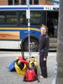
Public transit geohash
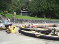
A nice sandy beach to launch from
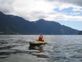
Under way
Stopping for a snack
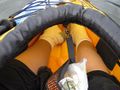
Snacks, cameras and feet are kept inside
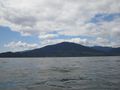
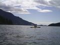
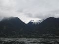
Paddling towards this island
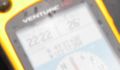
Being blown through the geohash
Aiming for the blue building
Deflating and drying
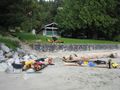
Everything spread out on logs to dry
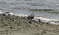
Visitors


