Difference between revisions of "2009-10-14 52 13"
imported>Relet (New page: {{subst:Expedition|lat=52|lon=13|date=2009-10-14}}) |
imported>FippeBot m (Location) |
||
| (5 intermediate revisions by one other user not shown) | |||
| Line 1: | Line 1: | ||
| − | |||
| − | |||
| − | |||
| − | |||
| − | |||
{{meetup graticule | {{meetup graticule | ||
| lat=52 | | lat=52 | ||
| Line 10: | Line 5: | ||
}} | }} | ||
| − | |||
__NOTOC__ | __NOTOC__ | ||
== Location == | == Location == | ||
| − | + | * A piece of forest near Alexanderdorf. They have a monastery there, and a disused Soviet airport further to the south. | |
== Participants == | == Participants == | ||
| − | + | * [[User:relet|relet]] | |
== Plans == | == Plans == | ||
| − | + | * --- | |
== Expedition == | == Expedition == | ||
| + | There's not much to say about this one. I parked the car in Alexanderdorf, not far from the hash. The hash was quite close, in the end of the woods right next to the settlement, and easily found. But as I meant to exercise my sore muscles (I overdid with the training on monday, and still feel them now) I had planned to walk in the direction of the airport, and maybe find a few geocaches on the way. It was a good bit of walking, and helped a lot with the muscles. With the caches I have been a little less lucky.. I did not find the first cache of a multi that would have led me onto the area of the airport, and therefore lost the motivation to do further sightseeing. However, I realized that a second cache (dubbed a multi, but really was not), lay nearby. This one was easily found, and saved me the day. | ||
== Tracklog == | == Tracklog == | ||
| Line 29: | Line 24: | ||
== Photos == | == Photos == | ||
| − | |||
| − | |||
| − | |||
| − | |||
| − | |||
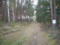
<gallery perrow="4"> | <gallery perrow="4"> | ||
| − | + | Image:200910145213-P1050189.JPG | Near the hash, facing west | |
| + | Image:200910145213-P1050190.JPG | Near the hash, facing south | ||
| + | Image:200910145213-P1050191.JPG | Near the hash, facing north (the camera, that is) | ||
| + | Image:200910145213-P1050192.JPG | At the hash | ||
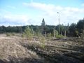
| + | Image:200910145213-P1050193.JPG | Not much of a sight | ||
| + | Image:200910145213-P1050194.JPG | Geobottle | ||
| + | Image:200910145213-P1050195.JPG | Left a mark | ||
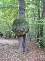
| + | Image:200910145213-P1050196.JPG | What, a spherical tree? | ||
| + | Image:200910145213-P1050197.JPG | Indeed. | ||
| + | Image:200910145213-P1050199.JPG | Prominent quench water fountain | ||
| + | Image:200910145213-P1050200.JPG | Rails | ||
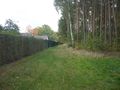
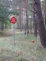
| + | Image:200910145213-P1050201.JPG | Double fence guarding the airport | ||
</gallery> | </gallery> | ||
| − | |||
| − | |||
| − | |||
| − | |||
| − | |||
| − | |||
| − | |||
[[Category:Expeditions]] | [[Category:Expeditions]] | ||
| − | |||
[[Category:Expeditions with photos]] | [[Category:Expeditions with photos]] | ||
| − | |||
| − | |||
| − | |||
| − | |||
| − | |||
[[Category:Coordinates reached]] | [[Category:Coordinates reached]] | ||
| − | + | {{location|DE|BB|TF}} | |
| − | |||
| − | |||
| − | |||
| − | |||
| − | |||
| − | |||
| − | |||
| − | |||
| − | |||
Latest revision as of 06:21, 8 August 2019
| Wed 14 Oct 2009 in 52,13: 52.1642309, 13.3248563 geohashing.info google osm bing/os kml crox |
Location
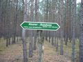
- A piece of forest near Alexanderdorf. They have a monastery there, and a disused Soviet airport further to the south.
Participants
Plans
- ---
Expedition
There's not much to say about this one. I parked the car in Alexanderdorf, not far from the hash. The hash was quite close, in the end of the woods right next to the settlement, and easily found. But as I meant to exercise my sore muscles (I overdid with the training on monday, and still feel them now) I had planned to walk in the direction of the airport, and maybe find a few geocaches on the way. It was a good bit of walking, and helped a lot with the muscles. With the caches I have been a little less lucky.. I did not find the first cache of a multi that would have led me onto the area of the airport, and therefore lost the motivation to do further sightseeing. However, I realized that a second cache (dubbed a multi, but really was not), lay nearby. This one was easily found, and saved me the day.
Tracklog
Photos
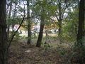
Near the hash, facing west
Near the hash, facing south
Near the hash, facing north (the camera, that is)
At the hash
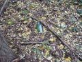
Not much of a sight
Geobottle
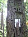
Left a mark
What, a spherical tree?
Indeed.
Prominent quench water fountain
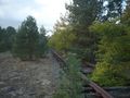
Rails
Double fence guarding the airport


