Difference between revisions of "2010-05-31 42 -87"
imported>Starbird m (Created page with '{{subst:Expedition |lat = 42 |lon = -87 |date = 2010-05-31 }}') |
imported>FippeBot m (Location) |
||
| (5 intermediate revisions by one other user not shown) | |||
| Line 1: | Line 1: | ||
| + | [[Image:2010-05-31 42 -87 sarah.jpg||thumb|left]] | ||
| − | |||
| − | |||
| − | |||
| − | |||
| − | |||
| − | |||
{{meetup graticule | {{meetup graticule | ||
| lat=42 | | lat=42 | ||
| Line 12: | Line 7: | ||
}} | }} | ||
| − | |||
__NOTOC__ | __NOTOC__ | ||
| + | |||
== Location == | == Location == | ||
| − | + | ||
| + | [http://www.shalom2.com Shalom Memorial Park], a Jewish cemetery in Arlington Heights. | ||
== Participants == | == Participants == | ||
| − | + | [[User:starbird|starbird]] | |
== Plans == | == Plans == | ||
| − | + | I was planning to spend the [http://en.wikipedia.org/wiki/Memorial_Day long weekend] at a backgammon tournament in Chicago. Before I left [[43,-89|Madison]] Friday morning, I checked the weekend's hashpoints for the Madison area, and also for some of the Chicago area graticules. Lo and behold, there was an easily accessible hash on Monday in a cemetery, right on my way home. Bonus for a land hash in the Kenosha grat, which is mostly water. Double bonus because I've never hashed in this grat. Triple bonus for a cemetery hash on Memorial Day! | |
== Expedition == | == Expedition == | ||
| − | |||
| − | + | I left the tournament (in Rosemont) around 3 o'clock Monday afternoon. The cemetery has an entrance on US Route 12, so it was literally on my route back to Madison. What could be easier? It was warm and sunny, perfect for a stroll in a cemetery. | |
| − | + | ||
| + | I was able to drive on the cemetery roads to within 100' or so, then I walked among the stones. There were very few three-dimensional memorials; most of the markers were flush with the ground, so the place has the appearance of a big park. One interesting feature of this cemetery is that there are a number of modern sculptures, which were pleasant to investigate. | ||
| + | |||
| + | The hashpoint moved around a bit, as usual, but with few trees and no buildings nearby I had less trouble with this than I often do. I tried to be circumspect about my activities; here's a guy walking around in circles with an imperfectly concealed GPS device in his hand. More squares than circles, actually -- I kept to the boundaries between the plots, so as to avoid walking over anyone. Under the circumstances, I chose not to leave even a temporary marker; there are enough permanent markers there! | ||
| + | |||
| + | If you look at my proof photo, you'll see that somebody lost their seven-year-old daughter in 1922. I suppose that everyone who could recall this event is also gone by now, so on this Memorial Day I am thinking about the Ancelovitz family and the tragedy that befell them almost 90 years ago. | ||
== Photos == | == Photos == | ||
| − | < | + | <gallery perrow="3"> |
| − | Image: | + | Image:2010-05-31 42 -87 proof.jpg | Proof |
| − | -- | + | Image:2010-05-31 42 -87 sarah.jpg | A little girl |
| − | + | Image:2010-05-31 42 -87 volvo.jpg | Hashing takes my vehicle all sorts of places | |
| + | Image:2010-05-31 42 -87 park.jpg | That's Noah's Ark, in the distance | ||
| + | Image:2010-05-31 42 -87 willow.jpg | It's really a lovely spot | ||
| + | Image:2010-05-31 42 -87 noah.jpg | Noah's Ark sculpture | ||
</gallery> | </gallery> | ||
== Achievements == | == Achievements == | ||
| − | |||
<!-- Add any achievement ribbons you earned below, or remove this section --> | <!-- Add any achievement ribbons you earned below, or remove this section --> | ||
| + | {{holy hash | latitude = 42 | longitude = -87 | date = 2010-05-31 | name = [[User:starbird|starbird]] | description = in a Jewish cemetery}} | ||
| + | {{Coffin potato | latitude = 42 | longitude = -87 | date = 2010-05-31 | deceased = Sarah Ancelovitz | deathdate = 1922-10-24 | name = [[User:starbird|starbird]] | image = 2010-05-31 42 -87 sarah.jpg }} | ||
| + | {{A Tale of Two Hashes challenge | ||
| − | + | | latitude = 42 | |
| − | + | | longitude = -87 | |
| − | [[ | + | | date = 2010-05-31 |
| + | | name = [[User:starbird|starbird]] | ||
| + | | place = [http://en.wikipedia.org/wiki/Arlington_Heights Arlington Heights] | ||
| + | }} | ||
<!-- Potential categories. Please include all the ones appropriate to your expedition --> | <!-- Potential categories. Please include all the ones appropriate to your expedition --> | ||
| − | |||
| − | |||
| − | |||
| − | |||
[[Category:Expeditions]] | [[Category:Expeditions]] | ||
| − | |||
[[Category:Expeditions with photos]] | [[Category:Expeditions with photos]] | ||
| − | |||
| − | |||
| − | |||
| − | |||
| − | |||
[[Category:Coordinates reached]] | [[Category:Coordinates reached]] | ||
| − | + | {{location|US|IL|CO}} | |
| − | |||
| − | |||
| − | |||
| − | |||
| − | |||
| − | |||
| − | |||
| − | |||
| − | |||
Latest revision as of 02:15, 9 August 2019

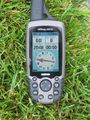
| Mon 31 May 2010 in 42,-87: 42.1293064, -87.9973130 geohashing.info google osm bing/os kml crox |
Location
Shalom Memorial Park, a Jewish cemetery in Arlington Heights.
Participants
Plans
I was planning to spend the long weekend at a backgammon tournament in Chicago. Before I left Madison Friday morning, I checked the weekend's hashpoints for the Madison area, and also for some of the Chicago area graticules. Lo and behold, there was an easily accessible hash on Monday in a cemetery, right on my way home. Bonus for a land hash in the Kenosha grat, which is mostly water. Double bonus because I've never hashed in this grat. Triple bonus for a cemetery hash on Memorial Day!
Expedition
I left the tournament (in Rosemont) around 3 o'clock Monday afternoon. The cemetery has an entrance on US Route 12, so it was literally on my route back to Madison. What could be easier? It was warm and sunny, perfect for a stroll in a cemetery.
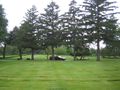
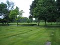
I was able to drive on the cemetery roads to within 100' or so, then I walked among the stones. There were very few three-dimensional memorials; most of the markers were flush with the ground, so the place has the appearance of a big park. One interesting feature of this cemetery is that there are a number of modern sculptures, which were pleasant to investigate.
The hashpoint moved around a bit, as usual, but with few trees and no buildings nearby I had less trouble with this than I often do. I tried to be circumspect about my activities; here's a guy walking around in circles with an imperfectly concealed GPS device in his hand. More squares than circles, actually -- I kept to the boundaries between the plots, so as to avoid walking over anyone. Under the circumstances, I chose not to leave even a temporary marker; there are enough permanent markers there!
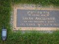
If you look at my proof photo, you'll see that somebody lost their seven-year-old daughter in 1922. I suppose that everyone who could recall this event is also gone by now, so on this Memorial Day I am thinking about the Ancelovitz family and the tragedy that befell them almost 90 years ago.
Photos
Proof
A little girl
Hashing takes my vehicle all sorts of places
That's Noah's Ark, in the distance
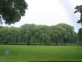
It's really a lovely spot
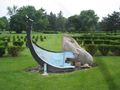
Noah's Ark sculpture


Achievements
starbird earned the Holy hash achievement
|

