Difference between revisions of "2010-08-05 45 -122"
imported>Michael5000 m (→Achievements) |
imported>Jiml (Add photo) |
||
| Line 28: | Line 28: | ||
== Plans == | == Plans == | ||
| − | Jim and APR | + | Jim and APR had a conversation via the Portland-Geohashers mailing list |
| − | + | * Jim Observed: Well, it isn't a globalhash, but it is pretty accessible. Or maybe not. It appears to be | |
| − | Well, it isn't a globalhash, but it is pretty accessible. Or maybe not. It appears to be | ||
on OR-30 North right near the Steel Bridge. I suspect you need to do it by car, which means you | on OR-30 North right near the Steel Bridge. I suspect you need to do it by car, which means you | ||
get to go for Speed Racer. | get to go for Speed Racer. | ||
| − | + | * APR pointed out: It looks like there is a multi-use path running underneath the bridge there. I won't be able to join you, but you should be able to find some parking nearby and get to the hashpoint on the ground if desired. | |
| − | |||
| − | |||
| − | |||
| − | |||
| − | It looks like there is a multi-use path running underneath the bridge there. I won't be able to join you, but you should be able to find some parking nearby and get to the hashpoint on the ground if desired. | ||
| − | |||
| − | |||
| − | I'm worried about fences preventing access with those RR tracks there | + | Jim's final wiki note was that: I'm worried about fences preventing access with those RR tracks there. [[User:Jiml|Jiml]] 20:40, 5 August 2010 (UTC) |
== Expedition == | == Expedition == | ||
| Line 52: | Line 44: | ||
In the course of ordinary daily work duties, I crossed the hashpoint at speed on the deck of the I-84W to I-5N ramp. I veered a little within the lane to ensure proper placement vis-a-vis the point, but otherwise would have -- like tens of thousands of other people -- reached this hashpoint in the course of my day even if I hadn't known about it. | In the course of ordinary daily work duties, I crossed the hashpoint at speed on the deck of the I-84W to I-5N ramp. I veered a little within the lane to ensure proper placement vis-a-vis the point, but otherwise would have -- like tens of thousands of other people -- reached this hashpoint in the course of my day even if I hadn't known about it. | ||
| − | {{ | + | {{cross that bridge |
| − | + | | latitude = 45 | |
| − | + | | longitude = -122 | |
| − | + | | date = 2010-08-05 | |
| − | + | | name = [[User:Michael5000|Michael5000]] | |
| − | | | + | }} |
| − | |||
| − | }} | ||
{{Easy_geohash | {{Easy_geohash | ||
| Line 66: | Line 56: | ||
| longitude = -122 | | longitude = -122 | ||
| date = 2010-08-05 | | date = 2010-08-05 | ||
| − | | name = Michael5000 | + | | name = [[User:Michael5000|Michael5000]] |
}} | }} | ||
| Line 87: | Line 77: | ||
}} | }} | ||
| − | (I've proposed the [[Over and Under Geohash Achievement|Over and Under Achievement]] to commemorate this kind of three-dimensional geohashing.) | + | (I've proposed the [[Over and Under Geohash Achievement|Over and Under Achievement]] to commemorate this kind of |
| + | three-dimensional geohashing.) | ||
=== Expedition Three=== | === Expedition Three=== | ||
| − | Jim left work and headed into Portland in search of the | + | Jim left work and headed into Portland in search of the hashpoint. He passed near it going east on |
Hwy 84, and turned around at the next exit to head back towards it. He didn't have to jump | Hwy 84, and turned around at the next exit to head back towards it. He didn't have to jump | ||
| − | around too much since he was in the left lane as he entered Hwy 30. He took the next exit after passing through the hashpoint, and looped back to see if he could | + | around too much since he was in the left lane as he entered Hwy 30. He took the next exit after passing through the hashpoint, and looped back to see if he could reach it at ground level. He wandered |
| − | + | around the Oregon Convention Center and finally found the nearby parking lot. The GPS say he | |
| − | was getting close, but it appeared to | + | was getting close, but it appeared to not be accessible due to a fence. (At least from that direction.) |
| − | it there | + | |
| + | He's glad that the 5000's made it there since he gave up on ground level access. | ||
| + | |||
| + | |||
| + | {{cross that bridge | ||
| + | | latitude = 45 | ||
| + | | longitude = -122 | ||
| + | | date = 2010-08-05 | ||
| + | | name = [[User:Jiml|Jim]] | ||
| + | }} | ||
| + | ==Photos== | ||
| + | <gallery> | ||
| + | Image:2010-08-05_45_-122-hashview.jpg|View of hash area from ground level | ||
| + | </gallery> | ||
== Achievements == | == Achievements == | ||
{{#vardefine:ribbonwidth|800px}} | {{#vardefine:ribbonwidth|800px}} | ||
| − | + | ||
* Land Geohash - for all 3 of us | * Land Geohash - for all 3 of us | ||
| − | + | ||
* Speed racer - Jim (M5K was in heavy traffic, so well below the limit) | * Speed racer - Jim (M5K was in heavy traffic, so well below the limit) | ||
| − | * | + | * Bicycle Geohashes for the 5000s as well. |
| − | |||
| − | |||
| − | |||
| − | |||
| − | |||
| − | [[Category:Expeditions]] | + | [[Category:Expeditions]][[Category:Expeditions with photos]] |
[[Category:Coordinates reached]] | [[Category:Coordinates reached]] | ||
Revision as of 18:37, 8 August 2010
| Thu 5 Aug 2010 in 45,-122: 45.5267251, -122.6645214 geohashing.info google osm bing/os kml crox |
Location
Underneath/On OR-30 in Portland, near the Steel Bridge.
Participants
Plans
Jim and APR had a conversation via the Portland-Geohashers mailing list
- Jim Observed: Well, it isn't a globalhash, but it is pretty accessible. Or maybe not. It appears to be
on OR-30 North right near the Steel Bridge. I suspect you need to do it by car, which means you get to go for Speed Racer.
- APR pointed out: It looks like there is a multi-use path running underneath the bridge there. I won't be able to join you, but you should be able to find some parking nearby and get to the hashpoint on the ground if desired.
Jim's final wiki note was that: I'm worried about fences preventing access with those RR tracks there. Jiml 20:40, 5 August 2010 (UTC)
Expedition
Expedition 5000.01
In the course of ordinary daily work duties, I crossed the hashpoint at speed on the deck of the I-84W to I-5N ramp. I veered a little within the lane to ensure proper placement vis-a-vis the point, but otherwise would have -- like tens of thousands of other people -- reached this hashpoint in the course of my day even if I hadn't known about it.
Michael5000 earned the Cross that bridge achievement
|
Michael5000 has visited an Easy Geohash
|
Expedition 5000.02
At 1800 hours, Michael5000 and Mrs.5000 set off by bicycle from their lovely Sunnyside home bearing west by northwest toward the Lloyd District. They crossed MLK on Lloyd Boulevard and pulled up under the ramp along a wide sidewalk overlooking the Eastbank Esplanade. A fence separated the sidewalk from a steep embankment, and the trusty GPS gadget placed the hashpoint 27 feet the other side of the fence.
Undeterred, the 5000s crossed I-84 on MLK and proceeded to a dead-end street off of the newly rerouted Couch (rhymes with "Pooch") Street, from which enterprising cyclists could gain access to a gravel track along the railroad lines. The hashpoint was right where we expected it -- downslope from the sidewalk overlook of a few minutes earlier, and underneath the freeway lane of earlier in the day. It was almost at the bottom of the embankment, in a neglected area of dusty blackberry vines, gravel, creosote, and bare dirt. We found an abandoned traffic pylon nearby and placed it atop the hashpoint to commemorate the spot at about 1835 hours.
Then we proceeded to Ole Ole at 22nd and Burnside for Burritos, and thence home again.
Michael5000 earned the The Over and Under Achievement
|
(I've proposed the Over and Under Achievement to commemorate this kind of three-dimensional geohashing.)
Expedition Three
Jim left work and headed into Portland in search of the hashpoint. He passed near it going east on Hwy 84, and turned around at the next exit to head back towards it. He didn't have to jump around too much since he was in the left lane as he entered Hwy 30. He took the next exit after passing through the hashpoint, and looped back to see if he could reach it at ground level. He wandered around the Oregon Convention Center and finally found the nearby parking lot. The GPS say he was getting close, but it appeared to not be accessible due to a fence. (At least from that direction.)
He's glad that the 5000's made it there since he gave up on ground level access.
Jim earned the Cross that bridge achievement
|
Photos
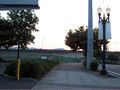
View of hash area from ground level

Achievements
- Land Geohash - for all 3 of us
- Speed racer - Jim (M5K was in heavy traffic, so well below the limit)
- Bicycle Geohashes for the 5000s as well.