Difference between revisions of "2010-08-07 60 25"
From Geohashing
imported>Marcius (→About) |
imported>FippeBot m (Location) |
||
| (14 intermediate revisions by 3 users not shown) | |||
| Line 3: | Line 3: | ||
| lon=25 | | lon=25 | ||
| date=2010-08-07 | | date=2010-08-07 | ||
| − | | graticule_name= | + | | graticule_name=Vantaa |
| − | | graticule_link= | + | | graticule_link=Vantaa, Finland}} |
== About == | == About == | ||
| − | These coordinates were located in the middle of nowhere | + | These coordinates were located in the middle of nowhere near Orimattila, Finland. As you can see photos below. |
| − | + | The coordinates were N60.87148°, E25.71461° (60°52.288, 25°42.877). | |
| + | |||
| + | Graticule on [[2010-08-07]]. (I do not understand why there are Vantaa, Finland. It should be Orimattila, Finland). | ||
| + | :''The [[graticule]] is the whole 1 degree x 1 degree rectangle. It is named after Vantaa because Vantaa is the largest town/city in that rectangle. So even if your expedition was at the other end, we still say "Vantaa, Finland". That is so people from other countries have only a small number of towns and cities to remember. In your expedition report, you can say that it is near the town of Orimattila, in the Vantaa graticule.'' -- [[User:Benjw|Benjw]] 20:30, 8 August 2010 (UTC) | ||
| + | Ok, now i understand! Thanks Benjw! -- marcius 08:23 2010.08.09 (UTC+2) | ||
== Participants == | == Participants == | ||
| − | [[User:marcius|marcius]] | + | [[User:marcius|marcius]] 13:20 2010.08.08 (UTC+2) |
| + | |||
| + | == Expedition == | ||
| + | |||
| + | [[User:marcius|marcius]]' first geohashing location in very hot day + 33,8 °C | ||
| − | == | + | == Photos == |
<gallery> | <gallery> | ||
| − | Image:I came there...JPG | + | Image:I came there...JPG|I came from there... |
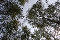
| − | Image:I go over there.JPG | + | Image:I go over there.JPG|...I'll go over there |
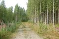
| − | Image:Approaching.JPG | + | Image:Approaching.JPG|Approaching |
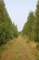
| − | Image:25 m, directly in front of me.JPG | + | Image:25 m, directly in front of me.JPG|25 m, directly in front of me |
| − | Image:Still 4 meters to go....JPG | + | Image:Still 4 meters to go....JPG|Still 4 meters to go... |
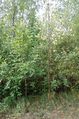
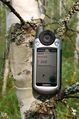
| − | Image:Ground zero.JPG | + | Image:Ground zero.JPG|Ground zero |
</gallery> | </gallery> | ||
| + | |||
| + | [[Category:Expeditions]][[Category:Expeditions with photos]] | ||
| + | [[Category:Coordinates reached]] | ||
| + | {{location|FI|16}} | ||
Latest revision as of 03:10, 9 August 2019
| Sat 7 Aug 2010 in Vantaa: 60.8714800, 25.7146075 geohashing.info google osm bing/os kml crox |
Contents
About
These coordinates were located in the middle of nowhere near Orimattila, Finland. As you can see photos below.
The coordinates were N60.87148°, E25.71461° (60°52.288, 25°42.877).
Graticule on 2010-08-07. (I do not understand why there are Vantaa, Finland. It should be Orimattila, Finland).
- The graticule is the whole 1 degree x 1 degree rectangle. It is named after Vantaa because Vantaa is the largest town/city in that rectangle. So even if your expedition was at the other end, we still say "Vantaa, Finland". That is so people from other countries have only a small number of towns and cities to remember. In your expedition report, you can say that it is near the town of Orimattila, in the Vantaa graticule. -- Benjw 20:30, 8 August 2010 (UTC)
Ok, now i understand! Thanks Benjw! -- marcius 08:23 2010.08.09 (UTC+2)
Participants
marcius 13:20 2010.08.08 (UTC+2)
Expedition
marcius' first geohashing location in very hot day + 33,8 °C
Photos
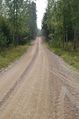
I came from there...
...I'll go over there
Approaching
25 m, directly in front of me
Still 4 meters to go...
Ground zero


