Difference between revisions of "2010-09-09 60 22"
imported>Jusu (→Photos) |
imported>Jusu (→Achievements) |
||
| Line 75: | Line 75: | ||
}} | }} | ||
| − | |||
| − | |||
| − | |||
| − | |||
| − | |||
| − | |||
| − | |||
| − | |||
| − | |||
[[Category:Expeditions]] | [[Category:Expeditions]] | ||
| − | |||
| − | |||
| − | |||
[[Category:Expeditions with photos]] | [[Category:Expeditions with photos]] | ||
| − | + | [[Category:Coordinates reached]] | |
| − | |||
| − | |||
| − | |||
| − | |||
| − | [[Category:Coordinates reached]] | ||
| − | |||
| − | |||
| − | |||
| − | |||
| − | |||
| − | |||
| − | |||
| − | |||
| − | |||
| − | |||
Revision as of 04:06, 12 September 2010
| Thu 9 Sep 2010 in 60,22: 60.1353974, 22.9979195 geohashing.info google osm bing/os kml crox |
Location
Map. The location seems to be on a forest path near Strömma channel. Jusu thinks he's been there before. Salo-Teijo-Strömma cycling route goes through the hashpoint.
What the heck. I looked Thursday's coordinates on Wednesday (2010-09-08). They were 60.1941066 22.8828243. By Thursday (2010-09-09) they had changed to 60.1353974, 22.9979195. I obviously have something to learn here.
Nevertheless, now the hashpoint is even easier to reach. It is on a road called Särkisalontie. See map.
Participants
Plans
Drive nearby by car on Thursday evening. Then there will be about 700 m - 1 km walking or cycling.
Aiming for Speed racer achievement on Thursday evening. Speed limit is 80 km/h.
Expedition
I drove through the hashpoint around 18:45 o'clock. Nothing special there.
Believe or not, I might have driven the same route today even if the hashpoint hadn't been there. Namely, my destination was a public sauna on the sea shore. It is open on Tuesday, Thursday and Sunday evenings on September. (The sauna of my normal summer and winter swimming place by a lake is closed on September.) Well, I have some kind of flu, but some sauna and quick swim won't make it worse, I guess... Water temperature was 16°C. It was much warmer just few weeks ago. It's getting colder rather quickly when there's wind and coldish nights.
Surprisingly, I have some very bad quality pictures of the sauna location also in 2010-08-12 60 22, and in Where's in a name geocache log.
Tracklog
I have a tracklog. Let's see whether I'll upload it somewhere some day.
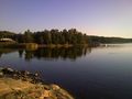
Photos
Series of bad photos continues.

Särkisalo info map. 2.0 km to hashpoint.
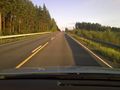
Approaching hashpoint
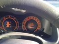
Speedometer, thermometer, chronometer, odometer, tachometer, fuelometer...
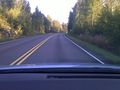
Da Hashpoint!
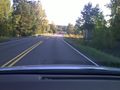
Passed the hashpoint
Small pier on the right is our swimming place. Sauna isn't visible. Ulkoluoto bridge is on the left.

Minigolf on the side of the bridge
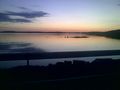
Sun has set


Achievements
Jusu earned the Speed racer achievement
|