Difference between revisions of "2010-10-22 -36 174"
imported>Greenslime m |
imported>FippeBot m (Location) |
||
| (One intermediate revision by one other user not shown) | |||
| Line 32: | Line 32: | ||
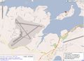
File:2010-10-22 -36 174 gmap.JPG|Just on land | File:2010-10-22 -36 174 gmap.JPG|Just on land | ||
File:2010-10-22 -36 174 Hash.jpg|Hash is by that pot plant | File:2010-10-22 -36 174 Hash.jpg|Hash is by that pot plant | ||
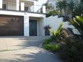
| − | File:2010-10-22 -36 174 Number 52 .jpg|The mansion that is number | + | File:2010-10-22 -36 174 Number 52 .jpg|The mansion that is number 51 The Terrace |
| − | File:2010-10-22 -36 174 Me.jpg|Chillaxing | + | File:2010-10-22 -36 174 Me.jpg|Chillaxing after a run |
File:2010-10-22 -36 174 Boat Club.jpg|Yet another boat club | File:2010-10-22 -36 174 Boat Club.jpg|Yet another boat club | ||
File:2010-10-22 -36 174 Ducks.jpg|Ducks | File:2010-10-22 -36 174 Ducks.jpg|Ducks | ||
| − | File:2010-10-22 -36 174 Herald Island.jpg|Background:Herald Island, Foreground:Guide light towers for the | + | File:2010-10-22 -36 174 Herald Island.jpg|Background:Herald Island, Foreground:Guide light towers for the Air Force runway behind me |
</gallery> | </gallery> | ||
| Line 46: | Line 46: | ||
[[Category:Expeditions with photos]] | [[Category:Expeditions with photos]] | ||
[[Category:Coordinates reached]] | [[Category:Coordinates reached]] | ||
| + | {{location|NZ|AUK}} | ||
Latest revision as of 04:19, 9 August 2019
| Fri 22 Oct 2010 in -36,174: -36.7786501, 174.6561468 geohashing.info google osm bing/os kml crox |
Location
A driveway, Herald Island, Auckland
Participants
Plans
All I thought when I saw this one this morning was how rightly PISSED JimmyNZ is going to be when he sees this. This hash falls pretty much bang on between both his house and workplace - about 1 km either way - damn, both honourable couch potato and cubicle hashes just out of his grasp. Hide the knives...
I will get it on his behalf after work.
I feel for you dude...
Expedition
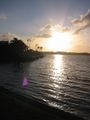
Another very easily attainable urban hash. This hash landed on Herald Island, a small piece of land joined to the mainland by a thin causeway. The most obvious thing in the neighbourhood is the Air Force Base (see map). I drove to the island after work, parked up and secretly and quickly exited my vehicle, sprinted up the driveway as far as I dared and snapped the picture. Then I proceeded to run around the island 3 times including the causeway, (10.5 km) good fun!
Those light towers trip me right out, remind me of stone henge or something equally mysterious and secretive.
Tracklog
Photos
Just on land
Hash is by that pot plant
The mansion that is number 51 The Terrace
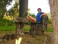
Chillaxing after a run
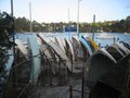
Yet another boat club
Ducks
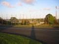
Background:Herald Island, Foreground:Guide light towers for the Air Force runway behind me


