Difference between revisions of "2010-11-04 -36 174"
imported>Greenslime m |
imported>Greenslime m |
||
| Line 5: | Line 5: | ||
}} | }} | ||
| − | + | ||
__NOTOC__ | __NOTOC__ | ||
== Location == | == Location == | ||
| Line 18: | Line 18: | ||
== Expedition == | == Expedition == | ||
| − | + | Yet another sea-side hash, got to love Auckland! I had three conflicting indicators of this hash location. The Google map street map showed it to be in the water, satellite view showed the point to be in a bushy patch, which I thought were mangroves and my GPS showed it to be on a blue square, probably land. Well I went along at mid-tide prepared for mud, and was pleasantly surprised to find the hash point was actually tar sealed! I parked at the top of the hill, meandered down, and took some photos. Check out the baby chickens, awww. There were some sky divers in the sky too, not something you see every day, or perhaps you do around here, the Air Force base is just up the road. This hash was only approximately 1 km from my my previous hash on Herald Island, and we wont even mention how close to [[User:JimmyNZ|JimmyNZ]]'s workplace... | |
| − | |||
| − | |||
| − | |||
== Photos == | == Photos == | ||
<gallery perrow="5"> | <gallery perrow="5"> | ||
| − | 2010-11-04_-36_174_To_the_hash.jpg|The approach | + | File:2010-11-04_-36_174_To_the_hash.jpg|The approach |
| − | + | File:2010-11-04_-36_174_View_.jpg|Yay, no mud | |
File:2010-11-04_-36_174_View2.jpg|View from the hash | File:2010-11-04_-36_174_View2.jpg|View from the hash | ||
File:2010-11-04 -36 174 Me.jpg|Me | File:2010-11-04 -36 174 Me.jpg|Me | ||
| Line 32: | Line 29: | ||
File:2010-11-04_-36_174_Sky.jpg|Sky divers | File:2010-11-04_-36_174_Sky.jpg|Sky divers | ||
File:2010-11-04 -36 174 Chickies.jpg|Aww | File:2010-11-04 -36 174 Chickies.jpg|Aww | ||
| − | |||
</gallery> | </gallery> | ||
Revision as of 04:18, 4 November 2010
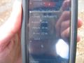
| Thu 4 Nov 2010 in -36,174: -36.7745109, 174.6169430 geohashing.info google osm bing/os kml crox |
Location
Edge of an estuary, Whenuapai, Auckland
Participants
- Greenslime
- JimmyNZ's very pissed off spirit
Plans
Oh no, JimmyNZ's turf again. This hash is highly likely in, or on the edge of a mangrove swamp which is near impossible... Well, there are degrees of impossible, depends on how exciting one wants to make it. Will scope it out this evening, will take old shoes
Expedition
Yet another sea-side hash, got to love Auckland! I had three conflicting indicators of this hash location. The Google map street map showed it to be in the water, satellite view showed the point to be in a bushy patch, which I thought were mangroves and my GPS showed it to be on a blue square, probably land. Well I went along at mid-tide prepared for mud, and was pleasantly surprised to find the hash point was actually tar sealed! I parked at the top of the hill, meandered down, and took some photos. Check out the baby chickens, awww. There were some sky divers in the sky too, not something you see every day, or perhaps you do around here, the Air Force base is just up the road. This hash was only approximately 1 km from my my previous hash on Herald Island, and we wont even mention how close to JimmyNZ's workplace...
Photos
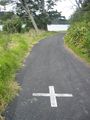
The approach
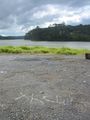
Yay, no mud
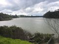
View from the hash

Me
Proof
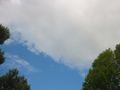
Sky divers
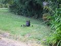
Aww


