Difference between revisions of "2010-12-01 45 -122"
imported>Aperfectring (Created page with '{{subst:Expedition |lat = 45 |lon = -122 |date = 2010-12-01 }}') |
imported>FippeBot m (Location) |
||
| (5 intermediate revisions by one other user not shown) | |||
| Line 1: | Line 1: | ||
| − | |||
<!-- If you did not specify these parameters in the template, please substitute appropriate values for IMAGE, LAT, LON, and DATE (YYYY-MM-DD format) | <!-- If you did not specify these parameters in the template, please substitute appropriate values for IMAGE, LAT, LON, and DATE (YYYY-MM-DD format) | ||
| Line 18: | Line 17: | ||
__NOTOC__ | __NOTOC__ | ||
== Location == | == Location == | ||
| − | + | South of Gresham, just off of a neighborhood road. The neighborhood looks to have larger, and more wooded, lots than are typical for the Portland area. | |
| + | |||
| + | {{PBGH_battleship | lat = 45 | lon = -122 | date = 2010-12-01}} | ||
== Participants == | == Participants == | ||
| − | + | [[User:Aperfectring|APR]] | |
== Plans == | == Plans == | ||
| − | + | APR has a half-day, and intends to head out just after he gets home from lunch. This should put him at the hashpoint by around 2:30. | |
== Expedition == | == Expedition == | ||
<!-- how it all turned out. your narrative goes here. --> | <!-- how it all turned out. your narrative goes here. --> | ||
| + | I left home at about 1PM, since I took a 1/2 day at work today, stopped to get gas, and made my way across Portland to the hashpoint. I got there just after 2PM, took pics, and started on my way back. I took surface streets the whole way back, and stopped to get some cleaning supplies and new shoes. It was wet, but that's about the only "notable" part of the expedition. The point was in a subdivision which was built into a hill, which was nice, but scenery is hard to see when it is foggy/rainy. I made a live post, but apparently it disappeared somewhere between my phone and the wiki. | ||
== Tracklog == | == Tracklog == | ||
| Line 33: | Line 35: | ||
== Photos == | == Photos == | ||
| − | |||
| − | |||
| − | |||
<gallery perrow="5"> | <gallery perrow="5"> | ||
| + | File:2010-12-01_45_-122_apr01.jpg | Proof | ||
| + | File:2010-12-01_45_-122_apr02.jpg | A self portrait at the hashpoint | ||
</gallery> | </gallery> | ||
| Line 43: | Line 44: | ||
<!-- Add any achievement ribbons you earned below, or remove this section --> | <!-- Add any achievement ribbons you earned below, or remove this section --> | ||
| − | |||
| − | |||
| − | |||
| − | |||
| − | |||
| − | |||
| − | |||
| − | |||
| − | |||
| − | |||
| − | |||
[[Category:Expeditions]] | [[Category:Expeditions]] | ||
| − | |||
[[Category:Expeditions with photos]] | [[Category:Expeditions with photos]] | ||
| − | |||
| − | |||
| − | |||
| − | |||
| − | |||
[[Category:Coordinates reached]] | [[Category:Coordinates reached]] | ||
| − | + | {{location|US|OR|CC}} | |
| − | |||
| − | |||
| − | |||
| − | |||
| − | |||
| − | |||
| − | |||
| − | |||
| − | |||
Latest revision as of 04:48, 9 August 2019
| Wed 1 Dec 2010 in 45,-122: 45.4541883, -122.4241432 geohashing.info google osm bing/os kml crox |
Location
South of Gresham, just off of a neighborhood road. The neighborhood looks to have larger, and more wooded, lots than are typical for the Portland area.
Today's battleship location is: F 5
Participants
Plans
APR has a half-day, and intends to head out just after he gets home from lunch. This should put him at the hashpoint by around 2:30.
Expedition
I left home at about 1PM, since I took a 1/2 day at work today, stopped to get gas, and made my way across Portland to the hashpoint. I got there just after 2PM, took pics, and started on my way back. I took surface streets the whole way back, and stopped to get some cleaning supplies and new shoes. It was wet, but that's about the only "notable" part of the expedition. The point was in a subdivision which was built into a hill, which was nice, but scenery is hard to see when it is foggy/rainy. I made a live post, but apparently it disappeared somewhere between my phone and the wiki.
Tracklog
Photos
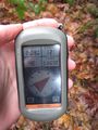
Proof

A self portrait at the hashpoint

