Difference between revisions of "2010-12-31 45 -122"
imported>Aperfectring |
imported>FippeBot m (Location) |
||
| (2 intermediate revisions by one other user not shown) | |||
| Line 27: | Line 27: | ||
== Expedition == | == Expedition == | ||
| − | + | Jim stopped by APR's place after dropping off his recycling, and then started heading out east in APR's car. Jim needed to pick up an order from an Asian market in Beaverton on the way, so they took a bit of a detour in getting to the hashpoint. They also stopped for Jim to get some lunch, and APR to get a drink. The drive over was long, but there was much talking of past expeditions and of their respective trips back to the eastern part of the country. | |
| + | |||
| + | Along the way, they were able to see 4 major mountains of the area: | ||
| + | * Mt. Hood (50 miles, 80km) East | ||
| + | * Mt. St. Helens (50 miles, 80km) North | ||
| + | * Mt. Adams (75 miles, 120km) North-East | ||
| + | * Mt. Rainier (100 miles, 160km) North | ||
| + | |||
| + | When they got to the hashpoint, it was behind some apartments in the common area, just off of the path. It was easy to reach, and just about at freezing, but windy, so it felt much colder. On the way back, they were caught in a traffic jam caused by an accident on the ramp between I-405 North and US 26 West. That backup added about 15 minutes to the journey back. | ||
== Photos == | == Photos == | ||
| Line 34: | Line 42: | ||
--> | --> | ||
<gallery perrow="5"> | <gallery perrow="5"> | ||
| + | File:2010-12-31 45 -122 apr 01.jpg | Proof! | ||
| + | File:2010-12-31 45 -122 apr 02.jpg | Jim at the hashpoint | ||
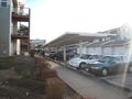
| + | File:2010-12-31 45 -122 apr 03.jpg | Apartments to the west | ||
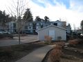
| + | File:2010-12-31 45 -122 apr 04.jpg | Apartments to the south | ||
| + | File:2010-12-31 45 -122 apr 05.jpg | Coldness proof | ||
</gallery> | </gallery> | ||
| − | |||
| − | |||
| − | |||
| − | |||
| − | |||
| − | |||
| − | |||
| − | |||
| − | |||
| − | |||
| − | |||
| − | |||
| − | |||
| − | |||
| − | |||
[[Category:Expeditions]] | [[Category:Expeditions]] | ||
| − | |||
[[Category:Expeditions with photos]] | [[Category:Expeditions with photos]] | ||
| − | |||
| − | |||
| − | |||
| − | |||
| − | |||
[[Category:Coordinates reached]] | [[Category:Coordinates reached]] | ||
| − | + | {{location|US|OR|MU}} | |
| − | |||
| − | |||
| − | |||
| − | |||
| − | |||
| − | |||
| − | |||
| − | |||
| − | |||
Latest revision as of 05:06, 9 August 2019
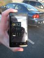
| Fri 31 Dec 2010 in 45,-122: 45.5368218, -122.3988455 geohashing.info google osm bing/os kml crox |
Location
In what appears to be an apartment complex out near Troutdale.
Participants
Plans
Jim is headed over to APR's place after dropping off some recycling. They will then run an errand or two on the way east to the hashpoint.
Expedition
Jim stopped by APR's place after dropping off his recycling, and then started heading out east in APR's car. Jim needed to pick up an order from an Asian market in Beaverton on the way, so they took a bit of a detour in getting to the hashpoint. They also stopped for Jim to get some lunch, and APR to get a drink. The drive over was long, but there was much talking of past expeditions and of their respective trips back to the eastern part of the country.
Along the way, they were able to see 4 major mountains of the area:
- Mt. Hood (50 miles, 80km) East
- Mt. St. Helens (50 miles, 80km) North
- Mt. Adams (75 miles, 120km) North-East
- Mt. Rainier (100 miles, 160km) North
When they got to the hashpoint, it was behind some apartments in the common area, just off of the path. It was easy to reach, and just about at freezing, but windy, so it felt much colder. On the way back, they were caught in a traffic jam caused by an accident on the ramp between I-405 North and US 26 West. That backup added about 15 minutes to the journey back.
Photos
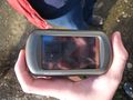
Proof!
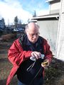
Jim at the hashpoint
Apartments to the west
Apartments to the south
Coldness proof


