Difference between revisions of "2011-05-03 50 4"
imported>Anabatica (→Photos) |
imported>Fippe ({{location|BE|BRU}}) |
||
| (6 intermediate revisions by 2 users not shown) | |||
| Line 1: | Line 1: | ||
| − | + | [[Image:{{{image|Anderlecht4.jpg}}}|thumb|left]] | |
| − | |||
| − | [[Image:{{{image| | ||
| − | |||
| − | |||
| − | |||
| − | |||
| − | |||
| − | |||
{{meetup graticule | {{meetup graticule | ||
| lat=50 | | lat=50 | ||
| Line 13: | Line 5: | ||
| date=2011-05-03 | | date=2011-05-03 | ||
}} | }} | ||
| − | |||
<!-- edit as necessary --> | <!-- edit as necessary --> | ||
__NOTOC__ | __NOTOC__ | ||
| Line 23: | Line 14: | ||
== Expedition == | == Expedition == | ||
| − | About 8 months ago I spilled beer on my laptop and the keyboard and | + | About 8 months ago I spilled beer on my laptop and the keyboard and trackpad stopped working. This is going somewhere, just bear with me. At that time, I'd been trying to do a geohash but I'd never found one that was easily accessible. I got a new laptop to replace the old one (which still worked, but was no longer portable whatsoever as it required a USB keyboard and mouse) and without the Brussels geohash page bookmarked, I promptly forgot all about it. |
I hung on to the busted laptop. For a while, I had both computers linked with Synergy but then the wireless card on the beer-soaked laptop died too, so recently I've just been using it to play music. A couple days ago, I noticed that the trackpad had mysteriously started working again. Today, I thought to check if the wireless was working. I opened up my browser and tested it by choosing a random page from my bookmarks... And the Internet worked, and that random page was the Brussels geohash page, and the hash for today was in a public place that was easily accessible with public transit. So I had to go. | I hung on to the busted laptop. For a while, I had both computers linked with Synergy but then the wireless card on the beer-soaked laptop died too, so recently I've just been using it to play music. A couple days ago, I noticed that the trackpad had mysteriously started working again. Today, I thought to check if the wireless was working. I opened up my browser and tested it by choosing a random page from my bookmarks... And the Internet worked, and that random page was the Brussels geohash page, and the hash for today was in a public place that was easily accessible with public transit. So I had to go. | ||
| Line 48: | Line 39: | ||
{{#vardefine:ribbonwidth|800px}} | {{#vardefine:ribbonwidth|800px}} | ||
<!-- Add any achievement ribbons you earned below, or remove this section --> | <!-- Add any achievement ribbons you earned below, or remove this section --> | ||
| − | + | {{land geohash | |
| − | + | | latitude = 50 | |
| − | + | | longitude = 4 | |
| − | + | | date = 2011-05-03 | |
| + | | name = anabatica | ||
| + | }} | ||
| + | {{holy hash | ||
| + | | latitude = 50 | ||
| + | | longitude = 4 | ||
| + | | date = 2011-05-03 | ||
| + | | name = anabatica | ||
| + | }} | ||
| + | {{Public transport geohash | ||
| + | | latitude = 50 | ||
| + | | longitude = 4 | ||
| + | | date = 2011-05-03 | ||
| + | | name = anabatica | ||
| + | }} | ||
| + | {{No_batteries_geohash | ||
| + | | latitude = 50 | ||
| + | | longitude = 4 | ||
| + | | date = 2011-05-03 | ||
| + | | name = anabatica | ||
| + | }} | ||
| + | {{Coffin potato | ||
| + | | latitude = 50 | ||
| + | | longitude = 4 | ||
| + | | date = 2011-05-03 | ||
| + | | deceased = Henri Engelen | ||
| + | | name = anabatica | ||
| + | }} | ||
[[Category:Expeditions]] | [[Category:Expeditions]] | ||
| − | + | [[Category:Expeditions with photos]] | |
[[Category:Expedition without GPS]] | [[Category:Expedition without GPS]] | ||
[[Category:Coordinates reached]] | [[Category:Coordinates reached]] | ||
| + | {{location|BE|BRU}} | ||
Latest revision as of 19:49, 2 January 2019

| Tue 3 May 2011 in 50,4: 50.8103727, 4.2785273 geohashing.info google osm bing/os kml crox |
Location
Cimetière de Vogelenzang, Anderlecht, Belgium.
Participants
Expedition
About 8 months ago I spilled beer on my laptop and the keyboard and trackpad stopped working. This is going somewhere, just bear with me. At that time, I'd been trying to do a geohash but I'd never found one that was easily accessible. I got a new laptop to replace the old one (which still worked, but was no longer portable whatsoever as it required a USB keyboard and mouse) and without the Brussels geohash page bookmarked, I promptly forgot all about it.
I hung on to the busted laptop. For a while, I had both computers linked with Synergy but then the wireless card on the beer-soaked laptop died too, so recently I've just been using it to play music. A couple days ago, I noticed that the trackpad had mysteriously started working again. Today, I thought to check if the wireless was working. I opened up my browser and tested it by choosing a random page from my bookmarks... And the Internet worked, and that random page was the Brussels geohash page, and the hash for today was in a public place that was easily accessible with public transit. So I had to go.
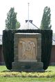
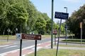
I took a tram and two metro lines to the nearest metro stop, Eddy Merckx, walked a short distance to the cemetery, and then walked through the cemetery to the hashpoint. I don't have a GPS unit so I looked up the location on satellite view of Google Maps and drew a rough map to take with me. The hashpoint was at the far end of the cemetery, near the third squiggly white bit from the centre. The squiggly white bits turned out to be flowerbeds of some sort and I had no difficulty identifying and reaching the correct location.
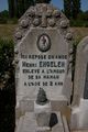
The nearest grave was located about 5m away, which I figured was close enough for a Coffin Potato award.
Despite this graticule's name, I believe this is the first geohash to be reached that was actually located in the Brussels Capital Region. For reasons I will not go into, this does not surprise me in the slightest.
Photos

The hashpoint.

Me at the hashpoint. Proof of date is in the EXIF data.
Coffin potato geohasher, 4-5m away from the hashpoint.

I had to pose with him, didn't I?


Achievements
anabatica earned the Land geohash achievement
|
anabatica earned the Holy hash achievement
|
anabatica earned the Public transport geohash achievement
|
anabatica earned the No Batteries Geohash Achievement
|
anabatica certifies that Henri Engelen earned the Coffin Potato Achievement
|