Difference between revisions of "2011-10-09 54 9"
From Geohashing
imported>Relet |
imported>FippeBot m (Location) |
||
| (One intermediate revision by one other user not shown) | |||
| Line 45: | Line 45: | ||
{{Graticule Hopper|count=50|name=relet}} | {{Graticule Hopper|count=50|name=relet}} | ||
| + | {{Multihash | latitude1 = 54 | longitude1 = 9 | latitude2 = 53 | longitude2 = 11 | date = 2011-10-09 | name = lyx and relet }} | ||
[[Category:Expeditions]] | [[Category:Expeditions]] | ||
[[Category:Expeditions with photos]] | [[Category:Expeditions with photos]] | ||
[[Category:Coordinates reached]] | [[Category:Coordinates reached]] | ||
| + | {{location|DE|SH|RD}} | ||
Latest revision as of 01:11, 13 August 2019
| Sun 9 Oct 2011 in 54,9: 54.4032732, 9.6177873 geohashing.info google osm bing/os kml crox |
Location
A field track close to highway 7
Participants
Plans
Drive by geohashing.
Expedition
This one was even easier. We parked next to the geohash, jumped a gate[1], ignored a sign that said "Danger to Life! Active surface mining area!"[2] and walked the ten meters along the path to the geohash.
- A cattle gate.
- The sign was referring to the lot next to the field whose track we were walking on.
Photos
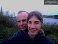
coordinates reached!

Achievements
relet earned the Half a Graticule Hopper Achievement
|
lyx and relet earned the Multihash Achievement
|