Difference between revisions of "2012-05-21 45 -122"
imported>Jiml m (Adjust location description) |
imported>FippeBot m (Location) |
||
| (3 intermediate revisions by one other user not shown) | |||
| Line 8: | Line 8: | ||
__NOTOC__ | __NOTOC__ | ||
== Location == | == Location == | ||
| − | In front of a house | + | In front of a house in Sellwood/East Moreland. Looks like it is right near the |
| − | sidewalk in a driveway. | + | sidewalk in a driveway. |
| + | |||
| + | But then it appeared to drift into the street... | ||
== Participants == | == Participants == | ||
| Line 17: | Line 19: | ||
== Plans == | == Plans == | ||
| − | Jim has something in Portland in the evening, so heading towards the | + | Jim has something in Portland in the evening, so heading towards the East side beforehand |
makes a lot of sense. | makes a lot of sense. | ||
| Line 23: | Line 25: | ||
== Expedition == | == Expedition == | ||
| − | So, I started out by heading west, to Tillamook, in search of the first of two hashpoints. | + | So, I started out by heading west, to Tillamook, in search of the [[2012-05-21_45_-123|first]] of two hashpoints. |
However, that expedition was thwarted, and I continued on to the Sellwood neighborhood, in | However, that expedition was thwarted, and I continued on to the Sellwood neighborhood, in | ||
search of the second one. | search of the second one. | ||
The route was pretty easy, though the traffic got slow at times. I remembered enough of | The route was pretty easy, though the traffic got slow at times. I remembered enough of | ||
| − | the Google maps so I didn't freak out when the point appeared to pass me by with no access. | + | the Google maps so I didn't freak out when the point's neighborhood appeared to pass me by with no access. |
I found the correct street and slowly drove down it, glancing at the GPS from time to time. | I found the correct street and slowly drove down it, glancing at the GPS from time to time. | ||
Eventually, the distance dropped to 19 feet, which struck me as odd, since it should have | Eventually, the distance dropped to 19 feet, which struck me as odd, since it should have | ||
| − | been on the sidewalk. But it had drifted, and was now in | + | been on the sidewalk. But it had drifted, and was now in the street. |
| − | I took a few pictures and headed off to do some work. No | + | I took a few pictures and headed off to do some work. No other geohashers (or anyone else) |
| + | were visible, nor appeared | ||
to have been around. | to have been around. | ||
| Line 50: | Line 53: | ||
{{#vardefine:ribbonwidth|800px}} | {{#vardefine:ribbonwidth|800px}} | ||
| − | + | {{Land geohash | |
| − | + | | latitude = 45 | |
| − | + | | longitude = -122 | |
| − | + | | year = 2012 | |
| + | | date = 2012-05-21 | ||
| + | | name = [[User:Jiml|Jim]] | ||
| + | }} | ||
| + | {{Geohashing Day | ||
| + | | latitude = 45 | ||
| + | | longitude = -122 | ||
| + | | year = 2012 | ||
| + | | coorddate = 2012-05-21 | ||
| + | | name = [[User:Jiml|Jim]] | ||
| + | | celebration = visiting a street in Sellwood | ||
| + | }} | ||
[[Category:Expeditions]] | [[Category:Expeditions]] | ||
| Line 60: | Line 74: | ||
[[Category:Expeditions with videos]] | [[Category:Expeditions with videos]] | ||
[[Category:Coordinates reached]] | [[Category:Coordinates reached]] | ||
| + | {{location|US|OR|MU}} | ||
Latest revision as of 04:07, 13 August 2019
| Mon 21 May 2012 in 45,-122: 45.4795496, -122.6426083 geohashing.info google osm bing/os kml crox |
Location
In front of a house in Sellwood/East Moreland. Looks like it is right near the sidewalk in a driveway.
But then it appeared to drift into the street...
Participants
Plans
Jim has something in Portland in the evening, so heading towards the East side beforehand makes a lot of sense.
Expedition
So, I started out by heading west, to Tillamook, in search of the first of two hashpoints. However, that expedition was thwarted, and I continued on to the Sellwood neighborhood, in search of the second one.
The route was pretty easy, though the traffic got slow at times. I remembered enough of the Google maps so I didn't freak out when the point's neighborhood appeared to pass me by with no access.
I found the correct street and slowly drove down it, glancing at the GPS from time to time. Eventually, the distance dropped to 19 feet, which struck me as odd, since it should have been on the sidewalk. But it had drifted, and was now in the street.
I took a few pictures and headed off to do some work. No other geohashers (or anyone else) were visible, nor appeared to have been around.
Photos
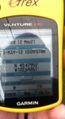
The GPS
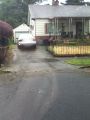
The nearby house
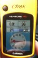
The GPS shortly after arrival


Achievements
Jim earned the Land geohash achievement
|
Jim earned the 2012 Geohashing Day achievement
|