Difference between revisions of "2012-09-15 52 0"
imported>Benjw m (→Expedition: missing punctuation) |
imported>FippeBot m (Location) |
||
| (One intermediate revision by one other user not shown) | |||
| Line 59: | Line 59: | ||
| date = 2012-09-15 | | date = 2012-09-15 | ||
| name = [[User:Benjw|Benjw]] | | name = [[User:Benjw|Benjw]] | ||
| − | | distance = | + | | distance = 46.3 km |
| + | | bothways = true | ||
| image = 2012-09-15 52 0 bike.jpg | | image = 2012-09-15 52 0 bike.jpg | ||
}} | }} | ||
| Line 79: | Line 80: | ||
[[Category:Expeditions with photos]] | [[Category:Expeditions with photos]] | ||
[[Category:Coordinates reached]] | [[Category:Coordinates reached]] | ||
| + | {{location|GB|ENG|CAM}} | ||
Latest revision as of 06:07, 13 August 2019
| Sat 15 Sep 2012 in Cambridge, UK: 52.3909236, 0.1767951 geohashing.info google osm bing/os kml crox |
Location
The edge of a field south of Coveney and west of Ely. As the crow flies, only 2 km from Wednesday's hashpoint which was successfully visited. This one should be similarly accessible.
Participants
Expedition
The route to this hashpoint was fairly easy anyway, but it was made even easier by the fact that Wednesday's hashpoint was only 2 km away and today's trip would follow exactly the same route (apart from the last 2 km, obviously).
My bike, which had broken its derailleur cable on that same trip, was still out of action, so I took MrsBenjw's bike. Hers is a road-bike, with higher gears and bigger wheels than my mountain bike, so I was interested to see what difference it would make. I was not disappointed.
I left the house at 2:55pm, and, as last time, I headed onto the guided busway cycle track the short distance towards Histon village, then headed north to Cottenham. Just as you are leaving Histon, there is a house with a large variety of metal animal sculptures on the front lawn -- I gather the owner makes them himself, and he has also produced some for the local school and other places. They always make me smile when I see them. The short distance to Cottenham was also swiftly covered, and then I was on the surprisingly long road north to Wilburton, called Twenty Pence Road. I'm not sure why.
I crossed the River Great Ouse, which is not as grand as its name suggests, passed through Wilburton and headed to Wentworth, which is a very small hamlet of little note other than today's geohash was in a field on its north side. I carried on up the road to Wednesday's geohash until the GPS arrow pointed sideways into the field, and at that point there was a convenient gap in the hedgerow leading into the field. I followed it and parked the bike against the hedge. The hashpoint was a mere 80 metres away, and again conveniently, was directly up a wide track at the side of the field.
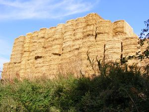
The cycle of 23.15 km had taken 52 minutes, which was a lot quicker than Wednesday's effort, so I sat in the sun for ten minutes or so and then went to find the hashpoint. I took photos of the GPS at exactly 4pm, then wandered back to the bike to sit in the sun for a while longer. I wasn't expecting anyone else to arrive, but you never know, and I wasn't in a hurry. Unfortunately I was wearing shorts and the stubble from the hay field was rather prickly, so after about ten minutes I decided to pack up and make my way home. I then discovered a stray chocolate bar which I'd left in my bike bag from Wednesday's expedition, so I paused a while longer while the chocolate disappeared.
Setting off at about 4:20, I quickly discovered why my journey here had been so much faster than the last time I'd tried -- going home again there was a stiff headwind and for much of the time I was cycling about 7 or 8 kph slower than I had been on the way. Still, it all helps towards the workout, and I knew it would only take an hour or so, so it wasn't too bad. I slogged into the wind for about 18 km, and it was only when I got back to the guided busway that I finally had some tail-wind to help me. I got back home at 5:24pm, which made for just under two hours' cycling, and 46.3 km.
I then poured myself a tasty beer, bought on our trip to Scotland, in celebration of reaching the 500 km cycling milestone, and it was only while editing the wiki afterwards that I double-checked the numbers and realised that this trip had actually made 499.3 km. Not wanting to waste good beer, though, I drank it anyway. As partial consolation, I notice that this was my 42nd successful hash in the Cambridge graticule, so, celebrating life, the universe, everything, and the fact that Douglas Adams was born here in Cambridge, I gratuitously created a ribbon to mark the occasion.
It was a nice day for a cycle and I enjoyed today's ride. Would have been better without the headwind on the way back.
Photos
Achievements
Benjw earned the Land geohash achievement
|
Benjw earned the Bicycle geohash achievement
|
Benjw earned the xkcd Nullaturion achievement
|
Benjw earned the Douglas Adams Was From Cambridge Achievement
|


