Difference between revisions of "2012-09-12 52 0"
From Geohashing
imported>Benjw (start expedition page; more later) |
imported>Benjw (gallery and ribbons) |
||
| Line 1: | Line 1: | ||
| − | + | [[Image:2012-09-12 52 0 happy hashers.jpg|thumb|left]] | |
{{meetup graticule | {{meetup graticule | ||
| lat=52 | | lat=52 | ||
| Line 17: | Line 17: | ||
Success. Write-up to follow. | Success. Write-up to follow. | ||
| − | == | + | == Photographic documentation == |
| − | + | The following photos were taken at the time of the expedition, but also see the [[2012-09-15 52 0]] expedition page for more photos taken along the same route to the hashpoint. | |
| + | |||
<gallery perrow="5"> | <gallery perrow="5"> | ||
| − | Image:2012- | + | Image:2012-09-12 52 0 ominous clouds.jpg | Rather ominous grey clouds as I set off. |
| + | Image:2012-09-12 52 0 old manor house.jpg | The old manor house in Wilburton. | ||
| + | Image:2012-09-12 52 0 byway sign.jpg | We turned off here... | ||
| + | Image:2012-09-12 52 0 muddy byway.jpg | ...onto this muddy and slippery track. | ||
| + | Image:2012-09-12 52 0 bikes.jpg | The bikes were parked at the side of the field. | ||
| + | Image:2012-09-12 52 0 gps.jpg | Point found! | ||
| + | Image:2012-09-12 52 0 happy hashers.jpg | Two soggy hashers. | ||
| + | Image:2012-09-12 52 0 coveney.jpg | Coveney village, 1 km north. | ||
| + | Image:2012-09-12 52 0 ely cathedral.jpg | Ely Cathedral, 5 km east. | ||
</gallery> | </gallery> | ||
| − | |||
| − | == | + | == Shiny ribbons == |
{{#vardefine:ribbonwidth|800px}} | {{#vardefine:ribbonwidth|800px}} | ||
| + | {{land geohash | ||
| + | | latitude = 52 | ||
| + | | longitude = 0 | ||
| + | | date = 2012-09-12 | ||
| + | | name = [[User:Benjw|Benjw]] | ||
| + | | image = 2012-09-12 52 0 gps.jpg | ||
| + | }} | ||
| + | {{bicycle geohash | ||
| + | | latitude = 52 | ||
| + | | longitude = 0 | ||
| + | | date = 2012-09-12 | ||
| + | | name = [[User:Benjw|Benjw]] | ||
| + | | distance = 28.0 km | ||
| + | | image = 2012-09-12 52 0 bikes.jpg | ||
| + | }} | ||
[[Category:Expeditions]] | [[Category:Expeditions]] | ||
| − | + | [[Category:Expeditions with photos]] | |
[[Category:Coordinates reached]] | [[Category:Coordinates reached]] | ||
Revision as of 14:20, 16 September 2012

| Wed 12 Sep 2012 in Cambridge, UK: 52.4066561, 0.1910491 geohashing.info google osm bing/os kml crox |
Location
A field south of Coveney and west of Ely.
Participants
- Benjw cycled from Cambridge.
- Dr-spangle cycled from Oundle.
Expedition
Success. Write-up to follow.
Photographic documentation
The following photos were taken at the time of the expedition, but also see the 2012-09-15 52 0 expedition page for more photos taken along the same route to the hashpoint.
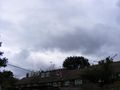
Rather ominous grey clouds as I set off.
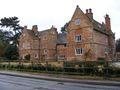
The old manor house in Wilburton.
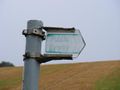
We turned off here...
- 2012-09-12 52 0 muddy byway.jpg
...onto this muddy and slippery track.
The bikes were parked at the side of the field.
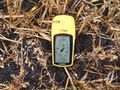
Point found!
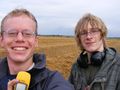
Two soggy hashers.
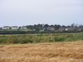
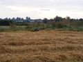
Coveney village, 1 km north.
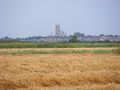
Ely Cathedral, 5 km east.


Shiny ribbons
Benjw earned the Land geohash achievement
|
Benjw earned the Bicycle geohash achievement
|