Difference between revisions of "2012-09-12 52 0"
From Geohashing
imported>Benjw (gallery and ribbons) |
imported>Benjw m (→Photographic documentation: wrong filename) |
||
| Line 24: | Line 24: | ||
Image:2012-09-12 52 0 old manor house.jpg | The old manor house in Wilburton. | Image:2012-09-12 52 0 old manor house.jpg | The old manor house in Wilburton. | ||
Image:2012-09-12 52 0 byway sign.jpg | We turned off here... | Image:2012-09-12 52 0 byway sign.jpg | We turned off here... | ||
| − | Image:2012-09-12 52 0 muddy | + | Image:2012-09-12 52 0 muddy track.jpg | ...onto this muddy and slippery track. |
Image:2012-09-12 52 0 bikes.jpg | The bikes were parked at the side of the field. | Image:2012-09-12 52 0 bikes.jpg | The bikes were parked at the side of the field. | ||
Image:2012-09-12 52 0 gps.jpg | Point found! | Image:2012-09-12 52 0 gps.jpg | Point found! | ||
Revision as of 14:21, 16 September 2012

| Wed 12 Sep 2012 in Cambridge, UK: 52.4066561, 0.1910491 geohashing.info google osm bing/os kml crox |
Location
A field south of Coveney and west of Ely.
Participants
- Benjw cycled from Cambridge.
- Dr-spangle cycled from Oundle.
Expedition
Success. Write-up to follow.
Photographic documentation
The following photos were taken at the time of the expedition, but also see the 2012-09-15 52 0 expedition page for more photos taken along the same route to the hashpoint.
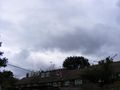
Rather ominous grey clouds as I set off.
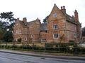
The old manor house in Wilburton.
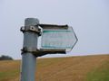
We turned off here...
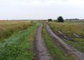
...onto this muddy and slippery track.
The bikes were parked at the side of the field.
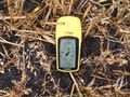
Point found!
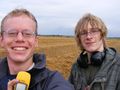
Two soggy hashers.
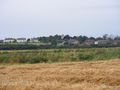
Coveney village, 1 km north.
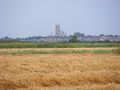
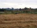
Ely Cathedral, 5 km east.


Shiny ribbons
Benjw earned the Land geohash achievement
|
Benjw earned the Bicycle geohash achievement
|