Difference between revisions of "2013-01-05 42 -90"
imported>Swensonj (start page) |
imported>FippeBot m (Location) |
||
| (10 intermediate revisions by 2 users not shown) | |||
| Line 1: | Line 1: | ||
| − | |||
| − | |||
| − | |||
| − | |||
| − | |||
| − | |||
| − | |||
| − | |||
| − | |||
| − | |||
{{meetup graticule | {{meetup graticule | ||
| lat=42 | | lat=42 | ||
| Line 15: | Line 5: | ||
}} | }} | ||
| − | |||
__NOTOC__ | __NOTOC__ | ||
== Location == | == Location == | ||
| − | + | Off County Road N, east of Beetown, WI | |
== Participants == | == Participants == | ||
| − | + | [[User:Swensonj|SwensonJ]] and kids | |
| − | |||
== Plans == | == Plans == | ||
| − | + | I'll try for the XKCD 4pm meetup; my [[Displaced origin geohash achievement]] at [[1977-02-25 42 -90]] is about a mile from here, so I'll try to go there either before or after this one. | |
| + | |||
| + | <del>If anyone's interested, please let me know!</del> All done! | ||
== Expedition == | == Expedition == | ||
| − | |||
| − | + | This is part one of a pseudomultihash. | |
| − | + | ||
| + | My kids and I ([[User:Swensonj|Swensonj]]) left home about 3:15, leaving my wife some alone time at home to rewire some light switches. It's a drive of about half an hour to the hashpoint, and it went well: the roads were good despite the cold weather. | ||
| + | |||
| + | The hashpoint was off Bee Road, a mile-long dead-end road terminating in a farm driveway. The homeowner was out, tossing corn cobs along the side of the drive. We asked his permission to walk across the field, and he said it wasn't his, but that the owner probably wouldn't mind. We did drive up to the owner's house, but they seemed to be away -- the lights were out and there wasn't a car visible in the dooryard. | ||
| + | |||
| + | The kids put on their snowshoes, but the snow didn't look that deep to me, so I decided to leave mine in the van. This was a mistake: where the snow had drifted, my feet sank in deeply. Still, the hashpoint wasn't far from the road, and my feet didn't have time to get all that cold or wet. The GPS registered the perfect location almost immediately, and we were ready to turn around. | ||
| + | |||
| + | Well... I was. The kids wanted to stomp around a bit in their snowshoes. I reminded them, though, that we had a retrohash to visit, which would mean a longer walk. This was the main reason we went out today: the point for my [[Displaced origin geohash achievement was about a mile from this hashpoint, in a direct line. It seemed better, though, to drive around the other three sides of a square on section roads, and take a shorter walk to [[1977-02-25 42 -90|part two]] of our adventure. | ||
== Photos == | == Photos == | ||
| − | <!-- | + | |
| − | Image: | + | <gallery perrow="4"> |
| − | -- | + | Image:2013-01-05 42 -90 Barn.jpg | Round barn on County Road N |
| − | + | Image:2013-01-05 42 -90 Cow.jpg | Cow #3, on the farm where the hash is located | |
| + | Image:2013-01-05 42 -90 Raptor.jpg | Raptor prints! | ||
| + | Image:2013-01-05 42 -90 Time.jpg | We were there for the XKCD meetup | ||
| + | Image:2013-01-05 42 -90 Proof.jpg | We got to the right place, too. | ||
| + | Image:2013-01-05 42 -90 Grin.jpg | SwensonJ grins at the hashpoint... | ||
| + | Image:2013-01-05 42 -90 Kids.jpg | ...as do his kids. | ||
| + | Image:2013-01-05 42 -90 Hash.jpg | View from the hashpoint | ||
</gallery> | </gallery> | ||
== Achievements == | == Achievements == | ||
{{#vardefine:ribbonwidth|800px}} | {{#vardefine:ribbonwidth|800px}} | ||
| − | + | {{land geohash | |
| − | + | | latitude = 42 | |
| + | | longitude = -90 | ||
| + | | date = 2013-01-05 | ||
| + | | name = [[User:Swensonj|Swensonj]] | ||
| + | | image = 2013-01-05_42_-90 Proof.jpg }} | ||
| + | {{Two to the N achievement | ||
| + | | count = 4 | ||
| + | | latitude = 42 | ||
| + | | longitude = -90 | ||
| + | | date = 2013-01-05 | ||
| + | | name = Swensonj | ||
| + | }} | ||
| + | {{gratuitous ribbon | ||
| + | | icon = Multihash.png | ||
| + | | latitude = 42 | ||
| + | | longitude = -90 | ||
| + | | date = 2013-01-05 | ||
| + | | achievement = Pseudomultihash achievement | ||
| + | | description = visiting the retrohash [[1977-02-25 42 -90]] and the | ||
| + | | name = [[User:Swensonj|Swensonj]] | ||
| + | }} | ||
| − | |||
| − | |||
| − | |||
| − | |||
| − | |||
| − | |||
| − | |||
| − | |||
[[Category:Expeditions]] | [[Category:Expeditions]] | ||
| − | |||
[[Category:Expeditions with photos]] | [[Category:Expeditions with photos]] | ||
| − | |||
| − | |||
| − | |||
| − | |||
| − | |||
[[Category:Coordinates reached]] | [[Category:Coordinates reached]] | ||
| − | + | {{location|US|WI|GA}} | |
| − | |||
| − | |||
| − | |||
| − | |||
| − | |||
| − | |||
| − | |||
| − | |||
| − | |||
| − | |||
| − | |||
| − | |||
| − | |||
| − | |||
| − | |||
| − | |||
| − | |||
Latest revision as of 00:31, 14 August 2019
| Sat 5 Jan 2013 in 42,-90: 42.8008605, -90.7884382 geohashing.info google osm bing/os kml crox |
Location
Off County Road N, east of Beetown, WI
Participants
SwensonJ and kids
Plans
I'll try for the XKCD 4pm meetup; my Displaced origin geohash achievement at 1977-02-25 42 -90 is about a mile from here, so I'll try to go there either before or after this one.
If anyone's interested, please let me know! All done!
Expedition
This is part one of a pseudomultihash.
My kids and I (Swensonj) left home about 3:15, leaving my wife some alone time at home to rewire some light switches. It's a drive of about half an hour to the hashpoint, and it went well: the roads were good despite the cold weather.
The hashpoint was off Bee Road, a mile-long dead-end road terminating in a farm driveway. The homeowner was out, tossing corn cobs along the side of the drive. We asked his permission to walk across the field, and he said it wasn't his, but that the owner probably wouldn't mind. We did drive up to the owner's house, but they seemed to be away -- the lights were out and there wasn't a car visible in the dooryard.
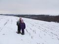
The kids put on their snowshoes, but the snow didn't look that deep to me, so I decided to leave mine in the van. This was a mistake: where the snow had drifted, my feet sank in deeply. Still, the hashpoint wasn't far from the road, and my feet didn't have time to get all that cold or wet. The GPS registered the perfect location almost immediately, and we were ready to turn around.
Well... I was. The kids wanted to stomp around a bit in their snowshoes. I reminded them, though, that we had a retrohash to visit, which would mean a longer walk. This was the main reason we went out today: the point for my [[Displaced origin geohash achievement was about a mile from this hashpoint, in a direct line. It seemed better, though, to drive around the other three sides of a square on section roads, and take a shorter walk to part two of our adventure.
Photos
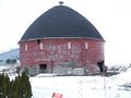
Round barn on County Road N
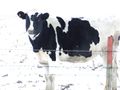
Cow #3, on the farm where the hash is located
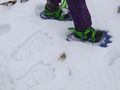
Raptor prints!
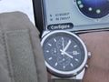
We were there for the XKCD meetup
We got to the right place, too.
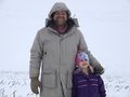
SwensonJ grins at the hashpoint...
...as do his kids.
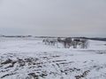
View from the hashpoint


Achievements
Swensonj earned the Land geohash achievement
|

Swensonj earned the Pseudomultihash achievement
|