Difference between revisions of "2013-04-27 66 25"
From Geohashing
imported>Isopekka (Created page with "thumb|left {{meetup graticule | lat=66 | lon=25 | date=2013-04-27 }} == Location == On the top of the hill Ounasvaara. About 2.3 ...") |
imported>Isopekka |
||
| Line 66: | Line 66: | ||
}} | }} | ||
| + | {{Walk geohash | ||
| + | | latitude = 66 | ||
| + | | longitude = 25 | ||
| + | | date = 2013-04-27 | ||
| + | | name = [[User:isopekka|isopekka]] | ||
| + | | distance = 5.9km | ||
| + | }} | ||
| + | |||
| + | {{Ribbon | ||
| + | |icon = Juggernaut.png | ||
| + | |color = darkviolet | ||
| + | |user = [[User:Isopekka|Isopekka]] | ||
| + | |achievement = [[Juggernaut achievement]] | ||
| + | |action = reaching a geohash in a straight line (with a deviation of approximately 1:32) on [[2013-04-27 66 25|2013-04-27]] | ||
| + | |category = Juggernaut achievement | ||
| + | }} | ||
| + | |||
| + | {{Geotrash | latitude = 66 | longitude = 25| date = 2013-04-27 | image = Geohash-27-4-2013 012.JPG }} | ||
Revision as of 14:51, 27 April 2013
| Sat 27 Apr 2013 in 66,25: 66.5022163, 25.8038107 geohashing.info google osm bing/os kml crox |
Contents
Location
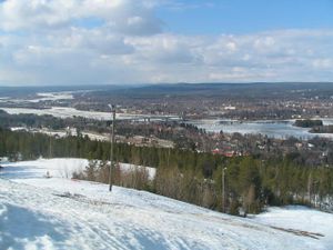
On the top of the hill Ounasvaara. About 2.3 km from my home.
Participants
Expedition
- Walking total 5.9 km
- Expedition took 2.5 h
- Physical effort (1-5): 3
My expedition started about 2:30 p.m. Finally I could try to get juggernaut achievement. The Hashpoint situated in the recreational area almost on the top of the slalom hill "Ounasvaara". The beginning was easy, but then I had to walk 2 km through the snowy forest up to the hill. Hard work, but I did it! The path to the hash and back to home can be found at [1] I was at the Hash about 3.30 p.m. I waited until the 4:00 p.m. to enjoy the official Saturday meetup alone. On the way back there was a broken glass bottle in the middle of the walking road. I cleaned it up and brought the trashes home. Very nice trip!
Photos
Achievements
isopekka earned the Land geohash achievement
|
isopekka earned the Walk geohash Achievement
|
Isopekka earned the Juggernaut achievement
|
This user earned the GeoTrash Geohash Achievement
|
Geohashing Expeditions and Plans on This Day
Expeditions and Plans
| 2013-04-27 | ||
|---|---|---|
| Ballarat, Australia | Snaplatitude, A mcdonalds employee | Some guys house in Miners Rest |
| Melbourne East, Australia | dazeller, coasttech | In the bush near Marysville. |
| Portland, Oregon | Jim | In a grove of trees in a public park in Beaverton! |
| Frankfurt am Main, Germany | Yakamoz | On a track across the seed plots, near Lich (the administrative district Gi... |
| Rovaniemi, Finland | isopekka | On the top of the hill Ounasvaara. About 2.3 km from my home. |


