Difference between revisions of "2013-03-12 52 0"
imported>Benjw (deploy expedition template) |
imported>Benjw (expedition report) |
||
| Line 1: | Line 1: | ||
| − | + | [[Image:2013-03-12 52 0 oil tanker.jpg|thumb|left]] | |
| − | |||
| − | |||
| − | [[Image: | ||
| − | |||
| − | |||
| − | |||
| − | |||
| − | |||
| − | |||
{{meetup graticule | {{meetup graticule | ||
| − | | lat= | + | | lat=52 |
| − | | lon= | + | | lon=0 |
| − | | date= | + | | date=2013-03-12 |
| + | | graticule_name=Cambridge, UK | ||
| + | | graticule_link=Cambridge, United Kingdom | ||
}} | }} | ||
| − | |||
| − | |||
| − | |||
== Location == | == Location == | ||
| − | + | In a field north of Wentworth, near Ely. Very close to the [[2012-09-12 52 0]] and [[2012-09-15 52 0]] hashpoints. | |
== Participants == | == Participants == | ||
| − | + | * [[User:Benjw|Benjw]] | |
| − | + | ||
| + | == Expedition == | ||
| + | I was interested to see the location for today's hashpoint -- very close to a small country road which I'd cycled along exactly six months previously, on the way to the [[2012-09-12 52 0]] hash, where I met [[User:Dr-spangle|Dr-spangle]] and broke my bike; the two events not being causally connected. I'd also cycled almost all the same route three days later, when the hashpoint was only a mile or two south. Today's hashpoint was neatly between the two. | ||
| − | + | Today was a lot colder, however, so the cycle wouldn't be nearly so pleasant, and after a long day at work I decided to drive there instead. | |
| − | |||
| − | + | After a short drive up the A10 Cambridge-to-Ely road -- a wiggly and pleasantly scenic meander through the south fens -- I turned off onto the A142 and then onto the lane to the hashpoint. I stopped at the side of the road next to the later of the two previous hashpoints, and took a photo through the gap in the hedge where I'd entered the field on a sunny afternoon last September. Not so sunny today. Then it was off again, but not very far, and soon I was parking the car in the entrance to an extremely muddy bridleway. | |
| − | |||
| − | + | I was pleased to find the magic GPS arrow pointing a short distance into the edge of the nearby field, and the hashpoint itself was reached by carefully walking in tractor ruts to avoid the small plants. The usual grin photo was taken, and I went back to the car. As with the previous two hashpoints near here, I could again see Ely Cathedral a few kilometers away, and today I had the added viewing pleasure of an old, rusty oil tanker on the side of the next field. | |
| − | |||
| − | == | + | == Photographic documentation == |
| − | < | + | <gallery> |
| − | Image: | + | Image:2013-03-12 52 0 hash revisited.jpg | The [[2012-09-15 52 0]] hashpoint. |
| − | -- | + | Image:2013-03-12 52 0 parking.jpg | It was extremely muddy. |
| − | + | Image:2013-03-12 52 0 hashpoint.jpg | The hashpoint in a field. | |
| + | Image:2013-03-12 52 0 gps.jpg | Proof of hash. | ||
| + | Image:2013-03-12 52 0 happy hasher.jpg | Yay! | ||
| + | Image:2013-03-12 52 0 ely cathedral.jpg | Ely Cathedral in the distance. | ||
| + | Image:2013-03-12 52 0 oil tanker.jpg | No idea why this was left here! | ||
</gallery> | </gallery> | ||
| − | == | + | == Shiny ribbons earned == |
| + | Just the one: | ||
{{#vardefine:ribbonwidth|800px}} | {{#vardefine:ribbonwidth|800px}} | ||
| − | + | {{land geohash | |
| − | + | | latitude = 52 | |
| − | + | | longitude = 0 | |
| − | + | | date = 2013-03-12 | |
| − | + | | name = [[User:Benjw|Benjw]] | |
| − | [[ | + | | image = 2013-03-12 52 0 hashpoint.jpg |
| − | + | }} | |
| − | |||
| − | |||
| − | |||
| − | |||
| − | |||
[[Category:Expeditions]] | [[Category:Expeditions]] | ||
| − | |||
[[Category:Expeditions with photos]] | [[Category:Expeditions with photos]] | ||
| − | |||
| − | |||
| − | |||
| − | |||
| − | |||
[[Category:Coordinates reached]] | [[Category:Coordinates reached]] | ||
| − | |||
| − | |||
| − | |||
| − | |||
| − | |||
| − | |||
| − | |||
| − | |||
| − | |||
| − | |||
| − | |||
| − | |||
| − | |||
| − | |||
| − | |||
| − | |||
| − | |||
| − | |||
Revision as of 15:11, 31 May 2013

| Tue 12 Mar 2013 in Cambridge, UK: 52.3972633, 0.1765148 geohashing.info google osm bing/os kml crox |
Location
In a field north of Wentworth, near Ely. Very close to the 2012-09-12 52 0 and 2012-09-15 52 0 hashpoints.
Participants
Expedition
I was interested to see the location for today's hashpoint -- very close to a small country road which I'd cycled along exactly six months previously, on the way to the 2012-09-12 52 0 hash, where I met Dr-spangle and broke my bike; the two events not being causally connected. I'd also cycled almost all the same route three days later, when the hashpoint was only a mile or two south. Today's hashpoint was neatly between the two.
Today was a lot colder, however, so the cycle wouldn't be nearly so pleasant, and after a long day at work I decided to drive there instead.
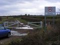
After a short drive up the A10 Cambridge-to-Ely road -- a wiggly and pleasantly scenic meander through the south fens -- I turned off onto the A142 and then onto the lane to the hashpoint. I stopped at the side of the road next to the later of the two previous hashpoints, and took a photo through the gap in the hedge where I'd entered the field on a sunny afternoon last September. Not so sunny today. Then it was off again, but not very far, and soon I was parking the car in the entrance to an extremely muddy bridleway.
I was pleased to find the magic GPS arrow pointing a short distance into the edge of the nearby field, and the hashpoint itself was reached by carefully walking in tractor ruts to avoid the small plants. The usual grin photo was taken, and I went back to the car. As with the previous two hashpoints near here, I could again see Ely Cathedral a few kilometers away, and today I had the added viewing pleasure of an old, rusty oil tanker on the side of the next field.
Photographic documentation

The 2012-09-15 52 0 hashpoint.
It was extremely muddy.
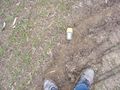
The hashpoint in a field.
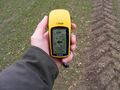
Proof of hash.
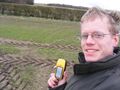
Yay!
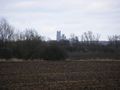
Ely Cathedral in the distance.
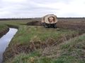
No idea why this was left here!


Shiny ribbons earned
Just the one:
Benjw earned the Land geohash achievement
|