Difference between revisions of "2013-09-21 -43 172"
imported>Quaternary (Created page with "{{subst:Expedition |lat = -43 |lon = 172 |date = 2013-09-21 }}") |
imported>FippeBot m (Location) |
||
| (15 intermediate revisions by one other user not shown) | |||
| Line 18: | Line 18: | ||
__NOTOC__ | __NOTOC__ | ||
== Location == | == Location == | ||
| − | + | ||
| + | Pines Beach, Canterbury, New Zealand | ||
== Participants == | == Participants == | ||
| − | + | The [[User:Quaternary|Quaternary]] ([[User talk:Quaternary|talk]]) family geohashers | |
| − | |||
== Plans == | == Plans == | ||
| − | + | ||
| + | Wow - what a great hash site - a beach - and on a Saturday. | ||
| + | |||
| + | What a shame the weather is so sub-optimal, but nevertheless, we are planning on being there at 4pm today. Maybe see some of you there? | ||
== Expedition == | == Expedition == | ||
| − | + | The rain stopped precipitating early afternoon - perfect timing, and we arrived at the spot around 3:30pm. It was at the top of a sand-dune about 200m from the edge of the Pacific Ocean - Ideal! So a lovely day out for dad, mum and the kids. We found a bit of driftwood that served as a marker-pole. On the strike of 4pm it started raining again, so sand-castling stopped for the day, and we headed back to civilisation. Oh, and we also found a geocache on the way, about 200 metres from the hash-point. | |
== Tracklog == | == Tracklog == | ||
| − | <! | + | |
| + | <gallery> | ||
| + | Image:2013_09_21_-43_172_Geolocation.PNG| Bingo! | ||
| + | </gallery> | ||
== Photos == | == Photos == | ||
| − | < | + | |
| − | Image: | + | <gallery perrow="4"> |
| − | -- | + | Image:2013_09_21_-43_172_The_Marker-Pole.JPG | The pole marks the spot |
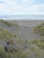
| − | + | Image:2013_09_21_-43_172_Panorama.JPG | Panorama | |
| + | Image:2013_09_21_-43_172_Understanding_Partner.JPG | Understanding partner | ||
| + | Image:2013_09_21_-43_172_Understanding_Daugther.JPG | Well, Dad, of all the random places you've dragged me, this one rates | ||
| + | Image:2013_09_21_-43_172_Time_to_head_to_the_beach.JPG | Let's head to the beach | ||
| + | Image:2013_09_21_-43_172_Collecting_shells.JPG | Collecting shells | ||
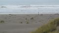
| + | Image:2013_09_21_-43_172_The_Pacfic_Ocean.JPG | The Pacific Ocean | ||
</gallery> | </gallery> | ||
== Achievements == | == Achievements == | ||
{{#vardefine:ribbonwidth|800px}} | {{#vardefine:ribbonwidth|800px}} | ||
| − | |||
| + | {{Geotrash | ||
| − | + | | latitude = -43 | |
| − | + | | longitude = 172 | |
| − | + | | date = 2013-09-21 | |
| + | | name = Quaternary | ||
| + | |||
| + | }} | ||
| − | |||
| − | |||
| − | |||
| − | |||
| − | |||
[[Category:Expeditions]] | [[Category:Expeditions]] | ||
| − | |||
[[Category:Expeditions with photos]] | [[Category:Expeditions with photos]] | ||
| − | |||
| − | |||
| − | |||
| − | |||
| − | |||
[[Category:Coordinates reached]] | [[Category:Coordinates reached]] | ||
| − | + | {{location|NZ|CAN}} | |
| − | |||
| − | |||
| − | |||
| − | |||
| − | |||
| − | |||
| − | |||
| − | |||
| − | |||
| − | |||
| − | |||
| − | |||
| − | |||
| − | |||
| − | |||
| − | |||
| − | |||
Latest revision as of 04:03, 14 August 2019
| Sat 21 Sep 2013 in -43,172: -43.3735723, 172.7089212 geohashing.info google osm bing/os kml crox |
Location
Pines Beach, Canterbury, New Zealand
Participants
The Quaternary (talk) family geohashers
Plans
Wow - what a great hash site - a beach - and on a Saturday.
What a shame the weather is so sub-optimal, but nevertheless, we are planning on being there at 4pm today. Maybe see some of you there?
Expedition
The rain stopped precipitating early afternoon - perfect timing, and we arrived at the spot around 3:30pm. It was at the top of a sand-dune about 200m from the edge of the Pacific Ocean - Ideal! So a lovely day out for dad, mum and the kids. We found a bit of driftwood that served as a marker-pole. On the strike of 4pm it started raining again, so sand-castling stopped for the day, and we headed back to civilisation. Oh, and we also found a geocache on the way, about 200 metres from the hash-point.
Tracklog
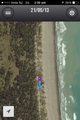
Bingo!

Photos
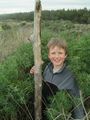
The pole marks the spot
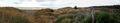
Panorama
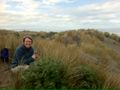
Understanding partner
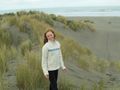
Well, Dad, of all the random places you've dragged me, this one rates
Let's head to the beach
Collecting shells
The Pacific Ocean


Achievements
Quaternary earned the GeoTrash Geohash Achievement
|