Difference between revisions of "2014-07-04 47 11"
imported>LeslieHapablap (An expedition message sent via Geohash Droid for Android.) |
imported>FippeBot m (Location) |
||
| (8 intermediate revisions by 2 users not shown) | |||
| Line 1: | Line 1: | ||
| + | [[Image:panorama_20140704_093607_width_px5082.jpg|left|900px]] | ||
<!-- If you did not specify these parameters in the template, please substitute appropriate values for IMAGE, LAT, LON, and DATE (YYYY-MM-DD format) | <!-- If you did not specify these parameters in the template, please substitute appropriate values for IMAGE, LAT, LON, and DATE (YYYY-MM-DD format) | ||
| Line 14: | Line 15: | ||
| date=2014-07-04 | | date=2014-07-04 | ||
}} | }} | ||
| − | + | {{ClearLeft}} | |
<!-- edit as necessary --> | <!-- edit as necessary --> | ||
__NOTOC__ | __NOTOC__ | ||
== Location == | == Location == | ||
<!-- where you've surveyed the hash to be --> | <!-- where you've surveyed the hash to be --> | ||
| + | Schlögelsbach near Innsbruck. | ||
== Participants == | == Participants == | ||
<!-- who attended: If you link to your wiki user name in this section, your expedition will be picked up by the various statistics generated for geohashing. You may use three tildes ~ as a shortcut to automatically insert the user signature of the account you are editing with. | <!-- who attended: If you link to your wiki user name in this section, your expedition will be picked up by the various statistics generated for geohashing. You may use three tildes ~ as a shortcut to automatically insert the user signature of the account you are editing with. | ||
--> | --> | ||
| + | * [[User:LeslieHapablap|LeslieHapablap]] ([[2014-06-22 47 10|previous]]|[[2014-07-13 47 11|next]]) | ||
| + | * [[User:LeslieHapablap/Waltraud|Waltraud]] | ||
== Plans == | == Plans == | ||
<!-- what were the original plans --> | <!-- what were the original plans --> | ||
| + | Bike there, bike back. | ||
== Expedition == | == Expedition == | ||
<!-- how it all turned out. your narrative goes here. --> | <!-- how it all turned out. your narrative goes here. --> | ||
| − | |||
| − | |||
| − | + | *Been there! Beautiful day, nice tour. -- [[User:LeslieHapablap|LeslieHapablap]] ([[User talk:LeslieHapablap|talk]]) 05:27, 4 July 2014 (EDT) | |
| − | + | ||
| − | + | Beautiful hashpoint for a road biking tour, I couldn't resist going. Perfect weather, nice distance, the spot easy accessible from the road just a few meters into a farm track. | |
| − | + | ||
| + | When I arrived, there were people sitting on the balcony of a nearby house, one of them with binoculars. When I pushed my bike towards the hashpoint on the farm track, he wanted to be helpful and informed me that this path isn't going anywhere, in particular not suited for a road bike. I said that's all right, I just want to go a few meters over there :D So when I performed my GPS dance and took the pictures I felt a bit watched. I was really glad that the point was directly on the track and I didn't have to jump the little fence to reach it, that would have raised some questions for sure. | ||
| + | |||
| + | On my way back I took my beloved bicycle highway along the Inn river which was quite nice despite the wind coming from up front. | ||
| + | |||
| + | == Photos == | ||
| + | |||
<gallery perrow="5"> | <gallery perrow="5"> | ||
| + | Image:IMG_20140704_093350_width_px800.jpg| View at the hashpoint. | ||
| + | Image:IMG_20140704_093603_width_px800.jpg| [[User:LeslieHapablap/Waltraud|Waltraud]] enjoyed it to be carried to all the way to the hashpoint. | ||
| + | Image:IMG_20140704_093743_width_px800.jpg| [[User:LeslieHapablap/Waltraud|Waltraud]] in the sun. | ||
| + | Image:IMG_20140704_095312_width_px800.jpg| Inn river. | ||
| + | Image:IMG_20140704_095317_width_px800.jpg| Way back home. | ||
| + | Image:screenshot_2014-07-04-09-40-52.png| Obligatory proof. | ||
</gallery> | </gallery> | ||
== Achievements == | == Achievements == | ||
{{#vardefine:ribbonwidth|800px}} | {{#vardefine:ribbonwidth|800px}} | ||
| − | |||
| + | {{land geohash | ||
| − | + | | latitude = 47 | |
| − | + | | longitude = 11 | |
| − | [[ | + | | date = 2014-07-04 |
| + | | name = [[User:LeslieHapablap|LeslieHapablap]] | ||
| − | + | }} | |
| − | + | {{bicycle geohash | |
| − | + | ||
| − | [[ | + | | latitude = 47 |
| − | + | | longitude = 11 | |
| + | | date = 2014-07-04 | ||
| + | | name = [[User:LeslieHapablap|LeslieHapablap]] | ||
| + | | bothways = true | ||
| + | |||
| + | }} | ||
| − | + | [[Category:Coordinates reached]] | |
[[Category:Expeditions]] | [[Category:Expeditions]] | ||
| − | |||
[[Category:Expeditions with photos]] | [[Category:Expeditions with photos]] | ||
| − | + | {{location|AT|T|SZ}} | |
| − | |||
| − | |||
| − | |||
| − | |||
| − | |||
| − | |||
| − | |||
| − | |||
| − | |||
| − | |||
| − | |||
| − | |||
| − | |||
| − | |||
| − | |||
| − | |||
| − | |||
| − | |||
| − | |||
| − | |||
| − | |||
| − | |||
| − | |||
Latest revision as of 00:37, 15 August 2019

| Fri 4 Jul 2014 in 47,11: 47.3268854, 11.6213256 geohashing.info google osm bing/os kml crox |
Location
Schlögelsbach near Innsbruck.
Participants
Plans
Bike there, bike back.
Expedition
- Been there! Beautiful day, nice tour. -- LeslieHapablap (talk) 05:27, 4 July 2014 (EDT)
Beautiful hashpoint for a road biking tour, I couldn't resist going. Perfect weather, nice distance, the spot easy accessible from the road just a few meters into a farm track.
When I arrived, there were people sitting on the balcony of a nearby house, one of them with binoculars. When I pushed my bike towards the hashpoint on the farm track, he wanted to be helpful and informed me that this path isn't going anywhere, in particular not suited for a road bike. I said that's all right, I just want to go a few meters over there :D So when I performed my GPS dance and took the pictures I felt a bit watched. I was really glad that the point was directly on the track and I didn't have to jump the little fence to reach it, that would have raised some questions for sure.
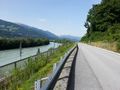
On my way back I took my beloved bicycle highway along the Inn river which was quite nice despite the wind coming from up front.
Photos
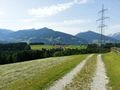
View at the hashpoint.
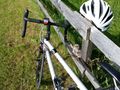
Waltraud enjoyed it to be carried to all the way to the hashpoint.
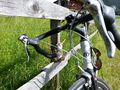
Waltraud in the sun.
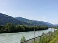
Inn river.
Way back home.
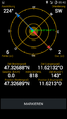
Obligatory proof.


Achievements
LeslieHapablap earned the Land geohash achievement
|
LeslieHapablap earned the Bicycle geohash achievement
|