Difference between revisions of "2014-12-28 28 -16"
imported>Sourcerer m (→Fixed auto-screw-up typo) |
imported>Sourcerer m (→Added Proof and Photos) |
||
| Line 17: | Line 17: | ||
This hashpiont was 3000km from home but only 25km from my holiday accommodation. I walked about 1km to the Estacion de Guaguas (Bus Station) and caught the 09:30 guagua to Los Christianos. From there it was about 3.5km to the hashpoint. The walk started through holiday accommodation but quickly turned into a mountain path, rocky and steep but not dangerous. The hashpoint was easily found and it was marked with a naturally occuring upside down Google pin made out of solidified volcanic lava. The route home was less easy. A circular route looked possible and indeed it was but I aborted several tracks due to steep ravines. A fitter walker could get through but not a 100kg 61 year old fat bastard! | This hashpiont was 3000km from home but only 25km from my holiday accommodation. I walked about 1km to the Estacion de Guaguas (Bus Station) and caught the 09:30 guagua to Los Christianos. From there it was about 3.5km to the hashpoint. The walk started through holiday accommodation but quickly turned into a mountain path, rocky and steep but not dangerous. The hashpoint was easily found and it was marked with a naturally occuring upside down Google pin made out of solidified volcanic lava. The route home was less easy. A circular route looked possible and indeed it was but I aborted several tracks due to steep ravines. A fitter walker could get through but not a 100kg 61 year old fat bastard! | ||
| − | The | + | == Photos == |
| + | |||
| + | <gallery perrow="5"> | ||
| + | Image:2014-12-28 28 -16 Sourcerer 1.jpg|The GPSR is sitting on the Haspoint | ||
| + | Image:2014-12-28 28 -16 Sourcerer 2.jpg|Proof | ||
| + | Image:2014-12-28 28 -16 Sourcerer 3.jpg|Nearby Terrain | ||
| + | Image:2014-12-28 28 -16 Sourcerer 4.jpg|Nearby Terrain with Bananas under nets in the distance | ||
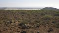
| + | Image:2014-12-28 28 -16 Sourcerer 5.jpg|Nearby Terrain | ||
| + | Image:2014-12-28 28 -16 Sourcerer 6.jpg|Track Log in Google Earth with a small Caldera visible. | ||
| + | </gallery> | ||
== Other geohashing expeditions on the same day == | == Other geohashing expeditions on the same day == | ||
Revision as of 13:46, 6 January 2015
| Sun 28 Dec 2014 in 28,-16: 28.0301417, -16.6937423 geohashing.info google osm bing/os kml crox |
Contents
Location
Between Los Christianos and Palm Mar, Santa Cruz de Tenerife, España.
Participants
Expedition
This hashpiont was 3000km from home but only 25km from my holiday accommodation. I walked about 1km to the Estacion de Guaguas (Bus Station) and caught the 09:30 guagua to Los Christianos. From there it was about 3.5km to the hashpoint. The walk started through holiday accommodation but quickly turned into a mountain path, rocky and steep but not dangerous. The hashpoint was easily found and it was marked with a naturally occuring upside down Google pin made out of solidified volcanic lava. The route home was less easy. A circular route looked possible and indeed it was but I aborted several tracks due to steep ravines. A fitter walker could get through but not a 100kg 61 year old fat bastard!
Photos
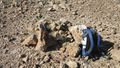
The GPSR is sitting on the Haspoint
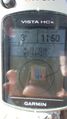
Proof
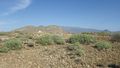
Nearby Terrain
Nearby Terrain with Bananas under nets in the distance
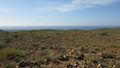
Nearby Terrain
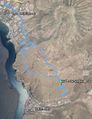
Track Log in Google Earth with a small Caldera visible.


Other geohashing expeditions on the same day
Expeditions and Plans
| 2014-12-28 | ||
|---|---|---|
| Santa Cruz de Tenerife, Spain | Sourcerer | Between Los Christianos and Palm Mar, Santa Cruz de Tenerife, España. |
| Big Rapids, Michigan | Mcbaneg, Rebekah, Katja, Susanne, Pat, Sandy, Sam | Parking lot of a charity-thrift store , Alpine Township, MI, USA |
| Mannheim, Germany | DODO | On a field next to Bretten |