Difference between revisions of "2015-01-18 52 1"
imported>Sourcerer (→Added new expedition) |
imported>FippeBot m (Location) |
||
| (2 intermediate revisions by one other user not shown) | |||
| Line 3: | Line 3: | ||
| lon=1 | | lon=1 | ||
| date=2015-01-18 | | date=2015-01-18 | ||
| + | | graticule_name=Norwich, UK | ||
| + | | graticule_link=Norwich, United Kingdom | ||
}} | }} | ||
| − | |||
__NOTOC__ | __NOTOC__ | ||
== Location == | == Location == | ||
| Line 31: | Line 32: | ||
</gallery> | </gallery> | ||
| − | == | + | {{Sourcerer_links |
| − | + | | prev = 2015-01-15 52 0 | |
| − | + | | curr = 2015-01-18 52 1 | |
| + | | next = 2015-01-19 50 0 | ||
| + | | date = 2015-01-18 | ||
| + | }} | ||
[[Category:Expeditions]] | [[Category:Expeditions]] | ||
[[Category:Expeditions with photos]] | [[Category:Expeditions with photos]] | ||
[[Category:Coordinates reached]] | [[Category:Coordinates reached]] | ||
| + | {{location|GB|ENG|SFK}} | ||
Latest revision as of 02:27, 15 August 2019
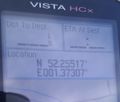
| Sun 18 Jan 2015 in Norwich, UK: 52.2551586, 1.3731073 geohashing.info google osm bing/os kml crox |
Location
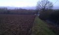
10 metres from the roadside field perimeter, south of Badingham, Suffolk, UK.
Participants
Expedition
- Arrived. -- Sourcerer (talk) @52.2552,1.3731 10:51, 18 January 2015 (GMT)
The hashpoint was 15 miles from home and close to a frequently travelled route. There was no need to use GPS to locate the point apart from the final shuffle. The hashpoint was about ten metres into a freshly ploughed muddy field. A few slippery and ungainly steps took me right to the point. The 100 metre walk back to the car was another shuffle, mainly to clear the mud from my all-terrain sandals.
The round trip by car started in fog with all the colours washed away, like fifty shades of grey with a feeble silver disc of sunlight struggling through the low clouds. The fog cleared and the weather became sunny with low cloud banks slowly clearing. The temperature was between 1 and 2C so not quite a frozen geohash.
Photos

Selfie

Muddy Feet
Proof
Hashpoint


Expeditions and Plans
| 2015-01-18 | ||
|---|---|---|
| Innsbruck, Austria | TheOneRing | next to the river Inn, in the city of Innsbruck (AUT) near the Westbahnhof ... |
| Wien, Austria | B2c, micsnare | Handelskai railway (20th District), Vienna |
| Mannheim, Germany | DODO | At the bank of the Lingenfelder Altrhein near the Mercedes-Benz plant in Ge... |
| Würzburg, Germany | Q-Owl, Q-Owla | In a little valley near Neuenstadt am Kocher. |
| Frankfurt am Main, Germany | DODO, QuarterCacher, M, Mampfred, LadyBB, EmmJay | On a field or a path near Niederems |
| Kassel, Germany | GeorgDerReisende | The hash lay on a field in Baunatal-Großenritte. |
| Norwich, United Kingdom | Sourcerer | 10 metres from the roadside field perimeter, south of Badingham, Suffolk, U... |
Sourcerer's Expedition Links
2015-01-15 52 0 - 2015-01-18 52 1 - 2015-01-19 50 0 - KML file download of Sourcerer's expeditions for use with Google Earth.