Difference between revisions of "2015-01-19 51 0"
imported>Sourcerer m ([http://www.openstreetmap.org/?lat=51.97730541&lon=.02522349&zoom=16&layers=B000FTF @51.9773,.0252]) |
imported>Sourcerer m (→New expedition added) |
||
| Line 1: | Line 1: | ||
| − | |||
| − | |||
| − | |||
| − | |||
| − | |||
| − | |||
| − | |||
| − | |||
| − | |||
| − | |||
{{meetup graticule | {{meetup graticule | ||
| lat=51 | | lat=51 | ||
| Line 15: | Line 5: | ||
}} | }} | ||
| − | + | ||
__NOTOC__ | __NOTOC__ | ||
| + | |||
== Location == | == Location == | ||
| − | + | ||
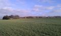
| + | In a field of winter wheat, west of Anstey and a quarry, Hertfordshire, UK. | ||
== Participants == | == Participants == | ||
| − | + | ||
| − | + | [[User:Sourcerer|Sourcerer]] | |
== Plans == | == Plans == | ||
| Line 29: | Line 21: | ||
== Expedition == | == Expedition == | ||
| − | |||
| + | *Arrived. -- [[User:Sourcerer|Sourcerer]] ([[User talk:Sourcerer|talk]]) [http://www.openstreetmap.org/?lat=51.97730541&lon=.02522886&zoom=16&layers=B000FTF @51.9773,.0252] 12:40, 19 January 2015 (GMT) | ||
| − | + | On Monday January 19th Sourcerer set out at 3am, drove 546 miles and attempted seven hashpoints in about 16 hours. Six were reached. This was success number four. | |
| − | + | ||
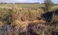
| − | + | This should have been routine but the first attempt was a dead end blocked by deep drainage ditches. Lyla the hash bitch refused to walk for the second time. First it was Gatwick flights and now it was Stansted flight noise that was upsetting her. After moving the car, the correct footpath was spotted so I re-parked in the original place, left Lyla in the car, and walked to the hashpoint in sunshine across a light dusting of melting snow. | |
== Photos == | == Photos == | ||
| − | + | ||
| − | |||
| − | |||
<gallery perrow="5"> | <gallery perrow="5"> | ||
| − | |||
Image:2015-01-19_51_0_Sourcerer_-1.jpg | [http://www.openstreetmap.org/?lat=51.97730541&lon=.02522349&zoom=16&layers=B000FTF @51.9773,.0252] | Image:2015-01-19_51_0_Sourcerer_-1.jpg | [http://www.openstreetmap.org/?lat=51.97730541&lon=.02522349&zoom=16&layers=B000FTF @51.9773,.0252] | ||
| + | Image:2015-01-19_51_0_Sourcerer_2.jpg | Deep Drainage Ditches | ||
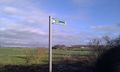
| + | Image:2015-01-19_51_0_Sourcerer_3.jpg | Joy - I Found the Path | ||
| + | Image:2015-01-19_51_0_Sourcerer_4.jpg | The Hashpoint and Quarry | ||
</gallery> | </gallery> | ||
| − | == | + | == Other geohashing expeditions on the same day == |
| − | |||
| − | |||
| − | |||
| − | |||
| − | |||
| − | |||
| − | |||
| − | |||
| − | |||
| − | |||
| − | |||
| − | |||
| − | |||
| − | |||
| − | + | {{expedition summaries|2015-01-19}} | |
[[Category:Expeditions]] | [[Category:Expeditions]] | ||
| − | |||
[[Category:Expeditions with photos]] | [[Category:Expeditions with photos]] | ||
| − | |||
| − | |||
| − | |||
| − | |||
| − | |||
[[Category:Coordinates reached]] | [[Category:Coordinates reached]] | ||
| − | |||
| − | |||
| − | |||
| − | |||
| − | |||
| − | |||
| − | |||
| − | |||
| − | |||
| − | |||
| − | |||
| − | |||
| − | |||
| − | |||
| − | |||
| − | |||
| − | |||
| − | |||
Revision as of 06:55, 20 January 2015
| Mon 19 Jan 2015 in 51,0: 51.9772974, 0.0252522 geohashing.info google osm bing/os kml crox |
Location
In a field of winter wheat, west of Anstey and a quarry, Hertfordshire, UK.
Participants
Plans
If successful, this will be hashpoint 5 of 7 today. --Sourcerer (talk) 10:26, 18 January 2015 (EST)
Expedition
- Arrived. -- Sourcerer (talk) @51.9773,.0252 12:40, 19 January 2015 (GMT)
On Monday January 19th Sourcerer set out at 3am, drove 546 miles and attempted seven hashpoints in about 16 hours. Six were reached. This was success number four.
This should have been routine but the first attempt was a dead end blocked by deep drainage ditches. Lyla the hash bitch refused to walk for the second time. First it was Gatwick flights and now it was Stansted flight noise that was upsetting her. After moving the car, the correct footpath was spotted so I re-parked in the original place, left Lyla in the car, and walked to the hashpoint in sunshine across a light dusting of melting snow.
Photos
Deep Drainage Ditches
Joy - I Found the Path
The Hashpoint and Quarry


Other geohashing expeditions on the same day
Expeditions and Plans
| 2015-01-19 | ||
|---|---|---|
| Atlanta, Georgia | NWoodruff | On the playground of an elementary school in Lawrenceville. |
| Jacksonville, Illinois | Mystrsyko, Dolphintreasure | In a field near Cox Creek, north of Ashland, IL. |
| Newark, New Jersey | OtherJack, Jevanyn | Back of someone's house in Emerson. |
| Brighton, United Kingdom | Sourcerer | 2) On deep frozen common heath-land north of North Chailey, East Sussex, UK... |
| Southampton, United Kingdom | Sourcerer | 3) Behind live-stock grade hedges, fences and gates, south of East Meon, Ha... |
| Eastbourne, United Kingdom | Sourcerer | 1) South east of a sewage works in a hard-frozen field, Newick, East Sussex... |
| Erfurt, Germany | FeepingCreature | Hash is in a parking lot in the town center of Erfurt. Extremely reachable.... |
| London West, United Kingdom | Sourcerer | 4) In a field of winter wheat, east of the A10 trunk road, between Buckland... |
| London East, United Kingdom | Sourcerer | 5) In a field of winter wheat, west of Anstey and a quarry, Hertfordshire, ... |
| Northampton, United Kingdom | Sourcerer | 6) A double pub geohash beside the River Witham in the middle of Boston, Li... |
| Cambridge, United Kingdom | Sourcerer | 7) In a muddy field, east of Boston, Lincolnshire, UK. |