Difference between revisions of "2015-02-03 52 1"
imported>Sourcerer m (→Added Expedition) |
imported>FippeBot m (Location) |
||
| (5 intermediate revisions by one other user not shown) | |||
| Line 3: | Line 3: | ||
| lon=1 | | lon=1 | ||
| date=2015-02-03 | | date=2015-02-03 | ||
| + | | graticule_name=Norwich, UK | ||
| + | | graticule_link=Norwich, United Kingdom | ||
}} | }} | ||
| − | |||
__NOTOC__ | __NOTOC__ | ||
| − | |||
== Location == | == Location == | ||
| Line 43: | Line 43: | ||
| longitude = 1 | | longitude = 1 | ||
| date = 2015-01-28 | | date = 2015-01-28 | ||
| + | | name = Sourcerer | ||
| + | }} | ||
| + | {{OpenStreetMap achievement | ||
| + | | latitude = 52 | ||
| + | | longitude = 1 | ||
| + | | date = 2015-02-03 | ||
| + | | OSMlink = 28599558 | ||
| + | | name = Sourcerer | ||
| + | }} | ||
| + | {{Last man standing | ||
| + | | latitude = 52 | ||
| + | | longitude = 1 | ||
| + | | date = 2015-02-03 | ||
| + | | gender = man | ||
| name = Sourcerer | | name = Sourcerer | ||
}} | }} | ||
| − | == | + | {{Sourcerer_links |
| − | + | | prev = 2015-02-02 52 1 | |
| − | + | | curr = 2015-02-03 52 1 | |
| + | | next = 2015-02-05 52 1 | ||
| + | | date = 2015-02-03 | ||
| + | }} | ||
[[Category:Expeditions]] | [[Category:Expeditions]] | ||
[[Category:Expeditions with photos]] | [[Category:Expeditions with photos]] | ||
[[Category:Coordinates reached]] | [[Category:Coordinates reached]] | ||
| + | {{location|GB|ENG|SFK}} | ||
Latest revision as of 02:37, 15 August 2019
| Tue 3 Feb 2015 in Norwich, UK: 52.1443573, 1.1867596 geohashing.info google osm bing/os kml crox |
Location
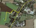
In a field a few paces off a public footpath at Ashbocking, Suffolk, UK.
Participants
Expedition
- Arrrived. -- Sourcerer (talk) @52.1444,1.1868 19:27, 3 February 2015 (GMT)
This was becoming routine but there was much more traffic. Midnight expeditions are quieter and quicker with light traffic. Sadly the Wednesday location is in a back garden and I prefer not to trouble the locals. With no need to span midnight, I set out earlier. It's a pity to break the run of consecutive achievements though. I wonder if I could train my hash-dog Lyla to slip her lead and run into people's back gardens. Then I'd have to rescue her while making profuse apologies and checking that the track-log was recording.
The next graticules are Cambridge but the point looks as though it's in a farm or light industrial zone and also London East which looks OK but it's too far on a day when I have to work.
I parked in the road next to the public footpath. There was a walk, slightly over 200 metres with only the last 30 metres off the path. The ground was partly frozen and there was very light rain with a few ice crystals mixed in - not quite a frozen achievement.
On the drive home there was a mixture of bright moonlight and snow showers.
Photos
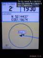
Arrived. @52.1444,1.1868
Tracklog


Achievements
Sourcerer earned the Consecutive geohash achievement
|
Sourcerer earned the OpenStreetMap achievement
|
Sourcerer earned the Last man standing achievement
|
Expeditions and Plans
| 2015-02-03 | ||
|---|---|---|
| Norwich, United Kingdom | Sourcerer | In a field a few paces off a public footpath at Ashbocking, Suffolk, UK. |
Sourcerer's Expedition Links
2015-02-02 52 1 - 2015-02-03 52 1 - 2015-02-05 52 1 - KML file download of Sourcerer's expeditions for use with Google Earth.