Difference between revisions of "2015-02-15 52 -0"
From Geohashing
imported>Sourcerer m (→Plan) |
imported>FippeBot m (Location) |
||
| (7 intermediate revisions by one other user not shown) | |||
| Line 1: | Line 1: | ||
| − | |||
| − | |||
| − | |||
| − | |||
| − | |||
| − | |||
| − | |||
| − | |||
| − | |||
| − | |||
{{meetup graticule | {{meetup graticule | ||
| lat=52 | | lat=52 | ||
| lon=-0 | | lon=-0 | ||
| date=2015-02-15 | | date=2015-02-15 | ||
| + | | graticule_name=Northampton, UK | ||
| + | | graticule_link=Northampton, United Kingdom | ||
}} | }} | ||
| − | |||
| − | |||
__NOTOC__ | __NOTOC__ | ||
== Location == | == Location == | ||
| − | + | ||
| + | 1) Bourne Lincolnshire - A new development for the over 55 age group. | ||
== Participants == | == Participants == | ||
| − | + | ||
| − | + | [[User:Sourcerer|Sourcerer]] | |
== Plans == | == Plans == | ||
| Line 31: | Line 22: | ||
== Expedition == | == Expedition == | ||
| − | |||
| − | == | + | *arrived -- [[User:Sourcerer|Sourcerer]] ([[User talk:Sourcerer|talk]]) [http://www.openstreetmap.org/?lat=52.77340651&lon=-.37400723&zoom=16&layers=B000FTF @52.7734,-.3740] 15:53, 15 February 2015 (GMT) |
| − | + | ||
| + | This was an easy one. After ignoring the private road sign, it was possible to park a few metres from the hashpoint. This was outside one of the new houses or perhaps just inside depending on the magic circle of uncertainty. | ||
== Photos == | == Photos == | ||
| − | + | ||
| − | |||
| − | |||
<gallery perrow="5"> | <gallery perrow="5"> | ||
| + | Image:2015-02-15_52_-0_Sourcerer_1424015548833.jpg | Proof. [http://www.openstreetmap.org/?lat=52.77340651&lon=-.37400723&zoom=16&layers=B000FTF @52.7734,-.3740] | ||
| + | Image:2015-02-15 52 -0 Sourcerer 1.jpg | The Hashpoint | ||
| + | Image:2015-02-15 52 -0 Sourcerer 2.jpg | The Hashpoint | ||
| + | Image:2015-02-13 52 -0 Sourcerer 3.jpg | Track Log | ||
</gallery> | </gallery> | ||
== Achievements == | == Achievements == | ||
{{#vardefine:ribbonwidth|800px}} | {{#vardefine:ribbonwidth|800px}} | ||
| − | |||
| + | {{Sourcerer_links | ||
| + | | prev = 2015-02-13 52 -1 | ||
| + | | curr = 2015-02-15 52 -0 | ||
| + | | next = 2015-02-15 52 0 | ||
| + | | date = 2015-02-15 | ||
| + | }} | ||
| − | |||
| − | |||
| − | |||
| − | |||
| − | |||
| − | |||
| − | |||
| − | |||
| − | |||
| − | |||
| − | |||
| − | |||
[[Category:Expeditions]] | [[Category:Expeditions]] | ||
| − | |||
[[Category:Expeditions with photos]] | [[Category:Expeditions with photos]] | ||
| − | |||
| − | |||
| − | |||
| − | |||
| − | |||
[[Category:Coordinates reached]] | [[Category:Coordinates reached]] | ||
| − | + | {{location|GB|ENG|LIN}} | |
| − | |||
| − | |||
| − | |||
| − | |||
| − | |||
| − | |||
| − | |||
| − | |||
| − | |||
| − | |||
| − | |||
| − | |||
| − | |||
| − | |||
| − | |||
| − | |||
| − | |||
Latest revision as of 02:44, 15 August 2019
| Sun 15 Feb 2015 in Northampton, UK: 52.7733735, -0.3738653 geohashing.info google osm bing/os kml crox |
Location
1) Bourne Lincolnshire - A new development for the over 55 age group.
Participants
Plans
Drive home from Staffordshire via these four hashpoints, the last is after midnight.
2015-02-15_52_-0 :: 2015-02-15_52_0 :: 2015-02-15_52_1 :: 2015-02-16_52_1
Expedition
- arrived -- Sourcerer (talk) @52.7734,-.3740 15:53, 15 February 2015 (GMT)
This was an easy one. After ignoring the private road sign, it was possible to park a few metres from the hashpoint. This was outside one of the new houses or perhaps just inside depending on the magic circle of uncertainty.
Photos
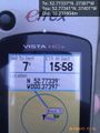
Proof. @52.7734,-.3740
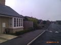
The Hashpoint
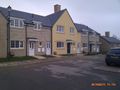
The Hashpoint
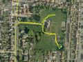
Track Log


Achievements
Expeditions and Plans
| 2015-02-15 | ||
|---|---|---|
| Northampton, United Kingdom | Sourcerer | 1) Bourne Lincolnshire - A new development for the over 55 age group. |
| Cambridge, United Kingdom | Sourcerer | 2) King's Lynn Sewage Works perimeter road. Expedition number two! |
| Norwich, United Kingdom | Sourcerer, ChromeCrusaders | 3) In woodland north east of the RAF air base at Coltishall under the fligh... |
Sourcerer's Expedition Links
2015-02-13 52 -1 - 2015-02-15 52 -0 - 2015-02-15 52 0 - KML file download of Sourcerer's expeditions for use with Google Earth.