Difference between revisions of "2015-06-26 51 1"
From Geohashing
imported>Sourcerer m (→Links) |
imported>Sourcerer m (→Achievement) |
||
| Line 41: | Line 41: | ||
}} | }} | ||
| − | + | ||
| − | |||
[[Category:Expeditions]] | [[Category:Expeditions]] | ||
[[Category:Expeditions with photos]] | [[Category:Expeditions with photos]] | ||
[[Category:Coordinates reached]] | [[Category:Coordinates reached]] | ||
| − | |||
Revision as of 01:17, 27 June 2015
| Fri 26 Jun 2015 in 51,1: 51.9558491, 1.0568826 geohashing.info google osm bing/os kml crox |
Location
Cattawade Creek, River Stour, Suffolk, UK.
Participants
Plans
An easy point in the Canterbury graticule.
Expedition
- Arrived. -- Sourcerer (talk) @51.9559,1.0569 22:26, 26 June 2015 (GMT+01:00)
Photos
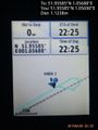
Proof. @51.9559,1.0569
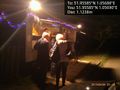
Food st hashpoint. @51.9559,1.0569


Achievements
Expeditions and Plans
| 2015-06-26 | ||
|---|---|---|
| Buffalo, New York | Pedalpusher | Middle of Mill Rd, East of Jewettville |
| Landshut, Germany | Danatar | in a wheat field between Graßlfing and Untergebraching, both of which are s... |
| Canterbury, United Kingdom | Sourcerer | 2) Cattawade Creek, River Stour, Suffolk, UK. |
| Norwich, United Kingdom | Sourcerer | 1) In a waterfowl wetland at Cley Marshes, Norfolk, UK. |
Sourcerer's Expedition Links
2015-06-26 52 1 - 2015-06-26 51 1 - 2015-06-27 52 0 - KML file download of Sourcerer's expeditions for use with Google Earth.