Difference between revisions of "2015-07-04 52 1"
imported>Sourcerer m (The Hashpoint.) |
imported>FippeBot m (Location) |
||
| (4 intermediate revisions by one other user not shown) | |||
| Line 3: | Line 3: | ||
| lon=1 | | lon=1 | ||
| date=2015-07-04 | | date=2015-07-04 | ||
| + | | graticule_name=Norwich, UK | ||
| + | | graticule_link=Norwich, United Kingdom | ||
}} | }} | ||
__NOTOC__ | __NOTOC__ | ||
| Line 19: | Line 21: | ||
== Expedition == | == Expedition == | ||
| + | *Arrived. -- [[User:Sourcerer|Sourcerer]] ([[User talk:Sourcerer|talk]]) [http://www.openstreetmap.org/?lat=52.68833220&lon=1.07977152&zoom=16&layers=B000FTF @52.6883,1.0798] 19:07, 4 July 2015 (GMT+01:00) | ||
| + | This went to plan. I went to the afternoon party. There was a hog-roast. Nice! We sang happy birthday. A steel band played and later one of the family sang. That was too loud and it hurt my ears but the singing was good. | ||
| + | |||
| + | After the heat of the day I joined the departing guests and headed for the hashpoint. This was on the road. I never got out of the car. My photo said 5 metres but later the GPSr dropped to 2 metres. The network failed after I uploaded my text message so I uploaded the images from home which was 35 km from the point. | ||
| − | |||
== Photos == | == Photos == | ||
<gallery perrow="5"> | <gallery perrow="5"> | ||
| − | |||
Image:2015-07-04_52_1_Sourcerer_1436033250716.jpg | Proof. | Image:2015-07-04_52_1_Sourcerer_1436033250716.jpg | Proof. | ||
| − | |||
Image:2015-07-04_52_1_Sourcerer_1436033430617.jpg | The Hashpoint. | Image:2015-07-04_52_1_Sourcerer_1436033430617.jpg | The Hashpoint. | ||
| + | Image:2015-07-04 52 1 Sourcerer.jpg | Track Log in Google Earth | ||
</gallery> | </gallery> | ||
| Line 41: | Line 45: | ||
}} | }} | ||
| − | |||
| − | |||
[[Category:Expeditions]] | [[Category:Expeditions]] | ||
[[Category:Expeditions with photos]] | [[Category:Expeditions with photos]] | ||
[[Category:Coordinates reached]] | [[Category:Coordinates reached]] | ||
| − | + | {{location|GB|ENG|NFK}} | |
Latest revision as of 04:15, 15 August 2019
| Sat 4 Jul 2015 in Norwich, UK: 52.6883163, 1.0798258 geohashing.info google osm bing/os kml crox |
Location
A roadside point at Hockering Heath, Norfolk, UK.
Participants
Plans
Go there during the day. Work around a birthday party I'm looking forward to.
Expedition
- Arrived. -- Sourcerer (talk) @52.6883,1.0798 19:07, 4 July 2015 (GMT+01:00)
This went to plan. I went to the afternoon party. There was a hog-roast. Nice! We sang happy birthday. A steel band played and later one of the family sang. That was too loud and it hurt my ears but the singing was good.
After the heat of the day I joined the departing guests and headed for the hashpoint. This was on the road. I never got out of the car. My photo said 5 metres but later the GPSr dropped to 2 metres. The network failed after I uploaded my text message so I uploaded the images from home which was 35 km from the point.
Photos
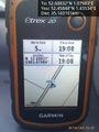
Proof.
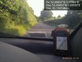
The Hashpoint.
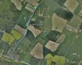
Track Log in Google Earth


Achievements
Expeditions and Plans
| 2015-07-04 | ||
|---|---|---|
| Aurora, Illinois | Rookiek13, Kiamx | By a tree in a Bolingbrook, IL Subdivision. |
| Seattle, Washington | Thomcat, AeroIllini, Trekkieyk, |
Roadside park in Redmond; will also visit Nike Missile Site S-13/14. |
| Norwich, United Kingdom | Sourcerer | A roadside point at Hockering Heath, Norfolk, UK. |
Sourcerer's Expedition Links
2015-07-03 52 1 - 2015-07-04 52 1 - 2015-07-05 52 0 - KML file download of Sourcerer's expeditions for use with Google Earth.