Difference between revisions of "2015-08-23 52 1"
From Geohashing
imported>Sourcerer m ([live picture] Proof. [http://www.openstreetmap.org/?lat=52.47705460&lon=1.35926843&zoom=16&layers=B000FTF @52.4771,1.3593]) |
imported>Sourcerer m (→New expedition) |
||
| Line 20: | Line 20: | ||
== Expedition == | == Expedition == | ||
| + | *Arrived. -- [[User:Sourcerer|Sourcerer]] ([[User talk:Sourcerer|talk]]) [http://www.openstreetmap.org/?lat=52.47704923&lon=1.35926843&zoom=16&layers=B000FTF @52.4770,1.3593] 21:54, 23 August 2015 (GMT+01:00) | ||
| + | This one was close to home and easy. There was a field opening big enough to park in and then it was a short walk across the stubble to the hashpoint. | ||
| − | |||
| − | |||
== Photos == | == Photos == | ||
<gallery perrow="5"> | <gallery perrow="5"> | ||
| − | |||
Image:2015-08-23_52_1_Sourcerer_1440363197805.jpg | Proof. [http://www.openstreetmap.org/?lat=52.47705460&lon=1.35926843&zoom=16&layers=B000FTF @52.4771,1.3593] | Image:2015-08-23_52_1_Sourcerer_1440363197805.jpg | Proof. [http://www.openstreetmap.org/?lat=52.47705460&lon=1.35926843&zoom=16&layers=B000FTF @52.4771,1.3593] | ||
| + | Image:2015-08-23 52 1 Sourcerer.jpg | Track in Google Earth | ||
</gallery> | </gallery> | ||
| Line 41: | Line 41: | ||
}} | }} | ||
| − | |||
| − | |||
[[Category:Expeditions]] | [[Category:Expeditions]] | ||
[[Category:Expeditions with photos]] | [[Category:Expeditions with photos]] | ||
[[Category:Coordinates reached]] | [[Category:Coordinates reached]] | ||
| − | |||
Revision as of 00:36, 24 August 2015
| Sun 23 Aug 2015 in 52,1: 52.4770078, 1.3592578 geohashing.info google osm bing/os kml crox |
Location
Four miles from home in a field north of Upgate Street, Norfolk, UK
Participants
Plans
Expedition one of two spanning midnight - 2015-08-23 52 1 - 2015-08-24 52 1 - ETA 22:35
Expedition
- Arrived. -- Sourcerer (talk) @52.4770,1.3593 21:54, 23 August 2015 (GMT+01:00)
This one was close to home and easy. There was a field opening big enough to park in and then it was a short walk across the stubble to the hashpoint.
Photos
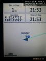
Proof. @52.4771,1.3593
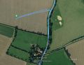
Track in Google Earth


Achievements
Expeditions and Plans
| 2015-08-23 | ||
|---|---|---|
| London East, United Kingdom | Huinesoron | In a field just outside Grays, Essex. |
| Kassel, Germany | GeorgDerReisende | The hash lay on the Kelzer Berg. |
| Cambridge, United Kingdom | Benjw | A field northeast of Littleport, Cambs. |
| Norwich, United Kingdom | Sourcerer | Four miles from home in a field north of Upgate Street, Norfolk, UK |
| Berlin, Germany | Someone went | An industrial building with a car service inside with parking spaces all ar... |
Sourcerer's Expedition Links
2015-08-22 52 1 - 2015-08-23 52 1 - 2015-08-24 52 1 - KML file download of Sourcerer's expeditions for use with Google Earth.