Difference between revisions of "2015-09-03 52 1"
imported>Sourcerer m ([live picture] Proof. [http://www.openstreetmap.org/?lat=52.73322701&lon=1.64246678&zoom=16&layers=B000FTF @52.7332,1.6425]) |
imported>Sourcerer m (→New Expedition) |
||
| Line 20: | Line 20: | ||
== Expedition == | == Expedition == | ||
| + | *Arrived. -- [[User:Sourcerer|Sourcerer]] ([[User talk:Sourcerer|talk]]) [http://www.openstreetmap.org/?lat=52.73322701&lon=1.64246678&zoom=16&layers=B000FTF @52.7332,1.6425] 00:00, 3 September 2015 (GMT+01:00) | ||
| + | There was a parking bay close by. This served a footpath a little to the north. The gate into the field was in the parking bay and open. There was a clover and grass crop, possibly for harvest or more likely for grazing. The clover had collected lots of rain in its cup shaped leaves. As I walked through, the cups emptied and soaked my feet and trouser leg bottoms. The storm clouds had dispersed and there was moon light. The hashpoint was on the banks of a drainage dyke. I got my evidence photo teetering on the edge of the bank, feeling somewhat unsafe. Fog was beginning to form. | ||
| − | |||
| − | |||
== Photos == | == Photos == | ||
<gallery perrow="5"> | <gallery perrow="5"> | ||
| − | |||
| − | |||
Image:2015-09-03_52_1_Sourcerer_1441234739306.jpg | Proof. [http://www.openstreetmap.org/?lat=52.73322701&lon=1.64246678&zoom=16&layers=B000FTF @52.7332,1.6425] | Image:2015-09-03_52_1_Sourcerer_1441234739306.jpg | Proof. [http://www.openstreetmap.org/?lat=52.73322701&lon=1.64246678&zoom=16&layers=B000FTF @52.7332,1.6425] | ||
| + | Image:2015-09-03 52 1 Sourcerer.jpg | Track in Google Earth | ||
</gallery> | </gallery> | ||
== Achievements == | == Achievements == | ||
{{#vardefine:ribbonwidth|700px}} | {{#vardefine:ribbonwidth|700px}} | ||
| − | |||
{{Sourcerer_links | {{Sourcerer_links | ||
| Line 43: | Line 41: | ||
}} | }} | ||
| − | |||
| − | |||
[[Category:Expeditions]] | [[Category:Expeditions]] | ||
[[Category:Expeditions with photos]] | [[Category:Expeditions with photos]] | ||
[[Category:Coordinates reached]] | [[Category:Coordinates reached]] | ||
| − | |||
Revision as of 00:21, 3 September 2015
| Thu 3 Sep 2015 in 52,1: 52.7331961, 1.6424850 geohashing.info google osm bing/os kml crox |
Location
In a field south of Horsey Wind pump, Norfolk, UK.
Participants
Plans
Expedition two of two spanning midnight - 2015-09-02 52 1 - 2015-09-03 52 1 - ETA 00:00.
Expedition
- Arrived. -- Sourcerer (talk) @52.7332,1.6425 00:00, 3 September 2015 (GMT+01:00)
There was a parking bay close by. This served a footpath a little to the north. The gate into the field was in the parking bay and open. There was a clover and grass crop, possibly for harvest or more likely for grazing. The clover had collected lots of rain in its cup shaped leaves. As I walked through, the cups emptied and soaked my feet and trouser leg bottoms. The storm clouds had dispersed and there was moon light. The hashpoint was on the banks of a drainage dyke. I got my evidence photo teetering on the edge of the bank, feeling somewhat unsafe. Fog was beginning to form.
Photos
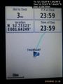
Proof. @52.7332,1.6425
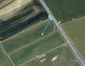
Track in Google Earth


Achievements
Expeditions and Plans
| 2015-09-03 | ||
|---|---|---|
| Portland, Oregon | Michael5000, Jim | On a street in the 60s, just north of the Banfield. |
| Mannheim, Germany | Tads | Almost on top of the Melibokus hill, in a wood close to Alsbach-Hähnlein. |
| London East, United Kingdom | Sourcerer | 2) In a field, east of Curling Tye Green, Essex, UK - placed.smarting.stitching... |
| Norwich, United Kingdom | Sourcerer | 1) erase.buzz.shame = a field south of Horsey Wind pump, Norfolk, UK. |
Sourcerer's Expedition Links
2015-09-02 52 1 - 2015-09-03 52 1 - 2015-09-03 51 0 - KML file download of Sourcerer's expeditions for use with Google Earth.