Difference between revisions of "2015-10-21 52 1"
imported>Sourcerer (→Planning) |
imported>FippeBot m (Location) |
||
| (8 intermediate revisions by one other user not shown) | |||
| Line 3: | Line 3: | ||
| lon=1 | | lon=1 | ||
| date=2015-10-21 | | date=2015-10-21 | ||
| + | | graticule_name=Norwich, UK | ||
| + | | graticule_link=Norwich, United Kingdom | ||
}} | }} | ||
__NOTOC__ | __NOTOC__ | ||
| Line 8: | Line 10: | ||
== Location == | == Location == | ||
| − | In the car park of Great Yarmouth Asda supermarket, Norfolk, UK. | + | 1) In the car park of Great Yarmouth Asda supermarket, Norfolk, UK. |
== Participants == | == Participants == | ||
| Line 16: | Line 18: | ||
== Plans == | == Plans == | ||
| − | Expedition one of | + | Expedition one of three spanning midnight - [[2015-10-21 52 1]] - [[2015-10-21 52 0]] - [[2015-10-22 52 0]] - ETA 21:28. |
== Expedition == | == Expedition == | ||
| + | I couldn't get a 3G signal to upload a live "arrived" message. I also temporarily lost my evidence photo but there is a track log. | ||
| + | The hashpoint was on the flood defence wall, right beside the metal barrier, built later, to improve the flood protection. This was a few paces up a grassy bank from the car parking place. I tried but failed to get some photos of Breydon Water and the Asda supermarket. | ||
== Photos == | == Photos == | ||
<gallery> | <gallery> | ||
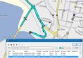
| + | Image:2015-10-21 52 1 Sourcerer.jpg | Track in Google Earth | ||
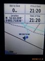
| + | Image:2015-10-21 52 1 Sourcerer Proof.jpg | Proof | ||
| + | Image:2015-10-21_52_1_Sourcerer_GPS_Proof.jpg | Proof image found! | ||
</gallery> | </gallery> | ||
| Line 32: | Line 39: | ||
| prev = 2015-10-20 52 1 | | prev = 2015-10-20 52 1 | ||
| curr = 2015-10-21 52 1 | | curr = 2015-10-21 52 1 | ||
| − | | next = 2015-10- | + | | next = 2015-10-21 52 0 |
| date = 2015-10-21 | | date = 2015-10-21 | ||
}} | }} | ||
| − | + | ||
| − | |||
[[Category:Expeditions]] | [[Category:Expeditions]] | ||
[[Category:Expeditions with photos]] | [[Category:Expeditions with photos]] | ||
[[Category:Coordinates reached]] | [[Category:Coordinates reached]] | ||
| − | + | {{location|GB|ENG|NFK}} | |
Latest revision as of 05:31, 15 August 2019
| Wed 21 Oct 2015 in Norwich, UK: 52.6120927, 1.7183627 geohashing.info google osm bing/os kml crox |
Location
1) In the car park of Great Yarmouth Asda supermarket, Norfolk, UK.
Participants
Plans
Expedition one of three spanning midnight - 2015-10-21 52 1 - 2015-10-21 52 0 - 2015-10-22 52 0 - ETA 21:28.
Expedition
I couldn't get a 3G signal to upload a live "arrived" message. I also temporarily lost my evidence photo but there is a track log.
The hashpoint was on the flood defence wall, right beside the metal barrier, built later, to improve the flood protection. This was a few paces up a grassy bank from the car parking place. I tried but failed to get some photos of Breydon Water and the Asda supermarket.
Photos
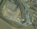
Track in Google Earth
Proof
Proof image found!


Achievements
Expeditions and Plans
| 2015-10-21 | ||
|---|---|---|
| Córdoba, Argentina | Onicofago | Landfill in the southern part of the city. Córdoba, Argentina |
| Spokane, Washington | Thomcat | In the churchyard beside the Mt. Hope cemetery. |
| Cambridge, United Kingdom | Sourcerer | 2) South of a wind farm south east of Swaffham, Norfolk, UK. |
| Norwich, United Kingdom | Sourcerer | 1) In the car park of Great Yarmouth Asda supermarket, Norfolk, UK. |
| Hannover, Germany | Fippe | located on a field in Sprockhof. |
Sourcerer's Expedition Links
2015-10-20 52 1 - 2015-10-21 52 1 - 2015-10-21 52 0 - KML file download of Sourcerer's expeditions for use with Google Earth.