Difference between revisions of "2015-11-07 49 8"
From Geohashing
imported>Q-Owl (Created page with "thumb|left|At the hashpoint {{meetup graticule | lat=49 | lon=8 | date=2015-11-07 }}__NOTOC__ == Location == In a field near [https://de.w...") |
imported>FippeBot m (Location) |
||
| (4 intermediate revisions by one other user not shown) | |||
| Line 1: | Line 1: | ||
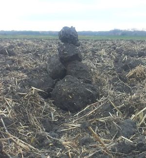
| − | [[Image:2015-11-07 49 8 hp.jpg|thumb|left| | + | [[Image:2015-11-07 49 8 hp.jpg|thumb|left|Hashpoint, marked with a few clods of earth]] |
{{meetup graticule | {{meetup graticule | ||
| lat=49 | | lat=49 | ||
| Line 16: | Line 16: | ||
== Plan == | == Plan == | ||
| − | Drive to Erfelden, walk to the hashpoint, find some caches, drive home. | + | Drive to Erfelden, walk to the hashpoint, find some caches, drive home. We try to be there about 15:00/15:15 h. |
| + | |||
| + | == Expedition == | ||
| + | |||
| + | We drove to Erfelden near the field, in which the hashpoint was. We took on our rain boots, walked about 400 m to the hashpoint and found it in a tilled field. I marked it with a little cairn made of a few clods of earth, took some photos and we went back to the car. :-) | ||
| + | |||
| + | After this we went 1/2 km to the geocache [http://coord.info/GC5QQEV GC5QQEV] but we could not get it without a magnet tied to >= 2 m string. :-( | ||
| + | |||
| + | == Photos == | ||
| + | <!-- Insert pictures between the gallery tags using the following format: | ||
| + | Image:2014-##-## ## ## Alpha.jpg | Witty Comment | ||
| + | --> | ||
| + | <gallery perrow="5" > | ||
| + | Image:2015-11-07 49 8 qf.jpg | Q-Owla at the edge of the field | ||
| + | Image:2015-11-07 49 8 proof.png | Proof | ||
| + | Image:2015-11-07 49 8 hp.jpg | Marked hashpoint | ||
| + | Image:2015-11-07 49 8 north.jpg | View north | ||
| + | Image:2015-11-07 49 8 west.jpg | View west | ||
| + | Image:2015-11-07 49 8 south.jpg | View south | ||
| + | Image:2015-11-07 49 8 east.jpg | View east | ||
| + | Image:2015-11-07 49 8 grin.jpg | Happy grin² | ||
| + | </gallery> | ||
| + | <!-- | ||
| + | List of uploaded Files: | ||
| + | http://wiki.xkcd.com/wgh/index.php?title=Special%3AListFiles&limit=50&ilsearch=&user=Q-Owl | ||
| + | More information: | ||
| + | http://wiki.xkcd.com/geohashing/User:Q-Owl#HowTo_in_this_Wiki | ||
| + | --> | ||
| + | |||
| + | == Achievements / Honorable Mention == | ||
| + | |||
| + | {{#vardefine:ribbonwidth|700px}} | ||
| + | {{land geohash | ||
| + | | latitude = 49 | ||
| + | | longitude = 8 | ||
| + | | date = 2015-11-07 | ||
| + | | name = Q-Owl & Q-Owla | ||
| + | }} | ||
| + | |||
| + | <!-- | ||
| + | Have I really been the only one? | ||
| + | {{Last man standing | ||
| + | | latitude = 49 | ||
| + | | longitude = 8 | ||
| + | | date = 2015-11-07 | ||
| + | | name = [[User:Q-Owl|Q-Owl]] | ||
| + | }} --> | ||
| + | |||
| + | == Other Geohashing Expeditions and Plans on this Day == | ||
| + | |||
| + | {{expedition summaries|2015-11-07}} | ||
| − | |||
| − | == | + | <!-- =============== USEFUL CATEGORIES FOLLOW ================ --> |
| + | <!-- Potential categories. Please include all the ones appropriate to your expedition | ||
| + | [[Category:Expeditions]] | ||
| + | [[Category:Coordinates reached]] | ||
| + | [[Category:Expeditions with photos]] | ||
| + | [[Category:Expeditions with videos]] | ||
| + | [[Category:Expedition without GPS]] | ||
| + | |||
| + | [[Category:Coordinates not reached]] | ||
| + | [[Category:Not reached - No public access]] | ||
| + | --> | ||
| + | [[Category:Expeditions]] | ||
| + | [[Category:Coordinates reached]] | ||
| + | [[Category:Expeditions with photos]] | ||
| − | + | [[Category: Meetup on 2015-11-07]] | |
| + | [[Category: Meetup in 49 8]] | ||
| + | {{location|DE|HE|GG}} | ||
Latest revision as of 05:42, 15 August 2019
| Sat 7 Nov 2015 in 49,8: 49.8409249, 8.4207014 geohashing.info google osm bing/os kml crox |
Location
In a field near Erfelden and Leeheim.
Participants
Plan
Drive to Erfelden, walk to the hashpoint, find some caches, drive home. We try to be there about 15:00/15:15 h.
Expedition
We drove to Erfelden near the field, in which the hashpoint was. We took on our rain boots, walked about 400 m to the hashpoint and found it in a tilled field. I marked it with a little cairn made of a few clods of earth, took some photos and we went back to the car. :-)
After this we went 1/2 km to the geocache GC5QQEV but we could not get it without a magnet tied to >= 2 m string. :-(
Photos
Achievements / Honorable Mention
Q-Owl & Q-Owla earned the Land geohash achievement
|
Other Geohashing Expeditions and Plans on this Day
Expeditions and Plans
| 2015-11-07 | ||
|---|---|---|
| Payson, Arizona | callmetym | 2015-11-07: callmetym got to the meetup a little late (25 min). |
| Newark, New Jersey | Team Jevanyn | Kensington Court, Whippany, NJ |
| St. Gallen, Switzerland | Lysogeny | A forest by Wilhelmsdorf, Germany. According to Swiss confederate maps the... |
| Mannheim, Germany | Q-Owl, Q-Owla | In a field near Erfelden and Leeheim. |
| Norwich, United Kingdom | Sourcerer | In a field, a few paces from the perimeter between North Walsham and the co... |
| Moscow, Russia | Alexey Nigin | Earth, Moscow, Походный проезд, within a parking lot. |


