Difference between revisions of "2016-05-04 49 11"
From Geohashing
imported>Klaus (template) |
imported>FippeBot m (Location) |
||
| (3 intermediate revisions by one other user not shown) | |||
| Line 1: | Line 1: | ||
| − | + | [[Image:{{{image|2016-05-04_49_11_view1.jpg}}}|thumb|left]] | |
| − | |||
| − | |||
| − | |||
| − | |||
| − | |||
| − | |||
| − | |||
{{meetup graticule | {{meetup graticule | ||
| lat=49 | | lat=49 | ||
| Line 15: | Line 8: | ||
}} | }} | ||
| − | |||
__NOTOC__ | __NOTOC__ | ||
== Location == | == Location == | ||
| − | + | between Lohndorf and Tiefenellern | |
== Participants == | == Participants == | ||
| − | + | * [[User:Klaus|Klaus]] | |
| − | |||
== Plans == | == Plans == | ||
| − | + | This one is way too easy. It is like 200m off a street I'll be driving tomorrow anyway (by car). | |
| + | So I'll gonna stop at around 19:00 and cash this easy geohash! | ||
== Expedition == | == Expedition == | ||
| − | + | I was stuck in a horrible pre-long-weekend traffic jam, so I arrived at around 20:45. | |
| + | As I already was late (traffic jam!) for the evening plans, I drove until 50m to the hash, took the obligatory proof photo and continued. | ||
| + | All in all, the whole expedition took only 6 minutes. | ||
| − | |||
| − | |||
== Photos == | == Photos == | ||
| − | |||
| − | |||
| − | |||
<gallery perrow="5"> | <gallery perrow="5"> | ||
| + | Image:2016-05-04_49_11_proof.jpg | Proof | ||
| + | Image:2016-05-04_49_11_view1.jpg | View from Geohash | ||
</gallery> | </gallery> | ||
== Achievements == | == Achievements == | ||
| − | {{ | + | {{land geohash |
| − | + | | latitude = 49 | |
| − | + | | longitude = 11 | |
| − | + | | date = 2016-05-04 | |
| − | + | | name = [[User:Klaus|Klaus]] | |
| − | [[ | + | }} |
| − | + | {{Template:Easy geohash | |
| − | + | | latitude = 49 | |
| − | + | | longitude = 11 | |
| − | [[ | + | | date = 2016-01-04 |
| − | + | | name = [[User:Klaus|Klaus]] | |
| + | }} | ||
| − | |||
| − | |||
[[Category:Expeditions]] | [[Category:Expeditions]] | ||
| − | |||
[[Category:Expeditions with photos]] | [[Category:Expeditions with photos]] | ||
| − | |||
| − | |||
| − | |||
| − | |||
| − | |||
[[Category:Coordinates reached]] | [[Category:Coordinates reached]] | ||
| − | + | {{location|DE|BY|BA}} | |
| − | |||
| − | |||
| − | |||
| − | |||
| − | |||
| − | |||
| − | |||
| − | |||
| − | |||
| − | |||
| − | |||
| − | |||
| − | |||
| − | |||
| − | |||
| − | |||
| − | |||
Latest revision as of 00:25, 16 August 2019
| Wed 4 May 2016 in 49,11: 49.9147023, 11.0612251 geohashing.info google osm bing/os kml crox |
Location
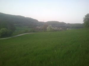
between Lohndorf and Tiefenellern
Participants
Plans
This one is way too easy. It is like 200m off a street I'll be driving tomorrow anyway (by car). So I'll gonna stop at around 19:00 and cash this easy geohash!
Expedition
I was stuck in a horrible pre-long-weekend traffic jam, so I arrived at around 20:45. As I already was late (traffic jam!) for the evening plans, I drove until 50m to the hash, took the obligatory proof photo and continued. All in all, the whole expedition took only 6 minutes.
Photos
Achievements
Klaus earned the Land geohash achievement
|
Klaus has visited an Easy Geohash
|


