Difference between revisions of "2016-07-21 52 1"
From Geohashing
imported>Sourcerer m (→New expedition) |
imported>FippeBot m (Location) |
||
| Line 50: | Line 50: | ||
[[Category:Expeditions with photos]] | [[Category:Expeditions with photos]] | ||
[[Category:Coordinates reached]] | [[Category:Coordinates reached]] | ||
| + | {{location|GB|ENG|SFK}} | ||
Latest revision as of 01:03, 16 August 2019
| Thu 21 Jul 2016 in Norwich, UK: 52.1428062, 1.2770453 geohashing.info google osm bing/os kml crox |
Location
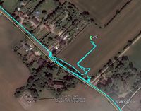
A field at Debach, Suffolk, UK.
Participants
Plans
Two of two spanning midnight - 2016-07-20 52 1 - 2016-07-21 52 1 - ETA 00:00.
Expedition
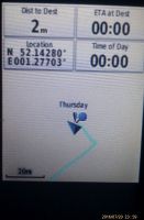
There was a parking bay outside the houses. A gap in the hedge led into the field. After a bit of searching, a route into the wheat field tractor tracks was located. The earth was wet and sticky with slippery clay. There was no 3G signal. I got my evidence photo at exactly midnight. It was easier to complete the walk on the road using another field entrance.
Photos
- Photo Gallery
Achievements
Sourcerer earned the Midnight Geohash achievement
|
Expeditions and Plans
| 2016-07-21 | ||
|---|---|---|
| Lockport, New York | Pedalpusher | In the woods by Acadia Park Cemetery |
| Norwich, United Kingdom | Sourcerer | A field at Debach, Suffolk, UK. |
| Kiuruvesi, Finland | Pastori, The Wife | Koutajärvi, Keitele. The point lies in a grove-ish forest, in a clearing ma... |
| Iisalmi, Finland | Pastori, The Wife | Maaninka. The point lies on a field next to Maaninkajärvi. |
Sourcerer's Expedition Links
2016-07-20 52 1 - 2016-07-21 52 1 - 2016-07-23 52 1 - KML file download of Sourcerer's expeditions for use with Google Earth.

