Difference between revisions of "2008-06-11 31 -84"
From Geohashing
imported>Robyn (New page: First Aerial Geohash Achieved (At least they told me I was first in the chat channel). On June 11th I was pilot in command of a commercial flight and had deviated north of track for weat...) |
imported>FippeBot m (Location) |
||
| (12 intermediate revisions by 3 users not shown) | |||
| Line 1: | Line 1: | ||
| − | + | {{meetup graticule | |
| + | | map=<map lat="31" lon="-84" date="2008-06-11" /> | ||
| + | | lat=31 | ||
| + | | lon=-84 | ||
| + | | date=2008-06-11 | ||
| + | }} | ||
| + | {{air geohash | latitude = 31 | longitude = -84 | date = 2008-06-11 | name = [[User:Robyn|Robyn]] | image = 2008-06-11 31 -84.jpg }} | ||
| + | '''The first Air Geohash flyover!''' | ||
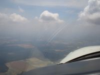
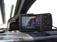
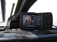
| − | + | On June 11, [[User:Robyn|I]] was pilot in command of a commercial flight and had deviated north of track for weather. At that time I saw that it was a very minor deviation to go right over that day's hashpoint in the [[Albany, Georgia]] graticule. So I did. [[Achievements#Proof|Required proof]] in the photos below. | |
| − | + | ==Pictures== | |
| + | <gallery widths="200px" heights="160px" perrow="2"> | ||
| + | Image:2008-06-11 31 -84.jpg|Photo of the geohash location | ||
| + | Image:2008-06-11 31 -84 almostthere.jpg|GPS just before flying over | ||
| + | Image:2008-06-11 31 -84 justpast.jpg|GPS just after flying over | ||
| + | Image:2008-06-11 31 -84 smile.jpg|[[User:Robyn|Robyn]]'s smile reflecting in the GPS. | ||
| + | </gallery> | ||
| − | + | ==Description== | |
| − | [[ | + | I'd rather not give details of the aircraft and trip because of the nature of the business. The flight time for the trip was not affected by the deviation, and there were no passengers on board, as it was a repositioning flight. |
| − | [[ | + | |
| − | [[ | + | [[Category:Expeditions]] |
| + | [[Category:Expeditions with photos]] | ||
| + | [[Category:Coordinates reached]] | ||
| + | {{location|US|GA|CU}} | ||
Latest revision as of 01:28, 6 August 2019
| Wed 11 Jun 2008 in 31,-84: 31.4657200, -84.7263600 geohashing.info google osm bing/os kml crox |
Robyn earned the Air geohash achievement
|
The first Air Geohash flyover!
On June 11, I was pilot in command of a commercial flight and had deviated north of track for weather. At that time I saw that it was a very minor deviation to go right over that day's hashpoint in the Albany, Georgia graticule. So I did. Required proof in the photos below.
Pictures
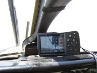
Robyn's smile reflecting in the GPS.
Description
I'd rather not give details of the aircraft and trip because of the nature of the business. The flight time for the trip was not affected by the deviation, and there were no passengers on board, as it was a repositioning flight.


