Difference between revisions of "2015-07-26 51 1"
imported>Sourcerer m (→Planning) |
m (→Achievements) |
||
| (13 intermediate revisions by 2 users not shown) | |||
| Line 1: | Line 1: | ||
| − | |||
| − | |||
| − | |||
| − | |||
| − | |||
| − | |||
| − | |||
| − | |||
| − | |||
| − | |||
{{meetup graticule | {{meetup graticule | ||
| lat=51 | | lat=51 | ||
| lon=1 | | lon=1 | ||
| date=2015-07-26 | | date=2015-07-26 | ||
| + | | graticule_name=Canterbury, UK | ||
| + | | graticule_link=Canterbury, United Kingdom | ||
}} | }} | ||
| − | |||
| − | |||
__NOTOC__ | __NOTOC__ | ||
| + | == Location == | ||
| − | + | On the south side of Alton Water, Suffolk, UK. | |
| − | |||
== Participants == | == Participants == | ||
| − | + | ||
| − | + | [[User:Sourcerer|Sourcerer]] | |
== Plans == | == Plans == | ||
| − | + | ||
| + | Expedition one of two spanning midnight - [[2015-07-26 51 1]] - [[2015-07-27 52 0]] - ETA 21:46 | ||
== Expedition == | == Expedition == | ||
| − | |||
| − | == | + | *Arrived. -- [[User:Sourcerer|Sourcerer]] ([[User talk:Sourcerer|talk]]) [http://www.openstreetmap.org/?lat=51.98201001&lon=1.12644732&zoom=16&layers=B000FTF @51.9820,1.1264] 21:38, 26 July 2015 (GMT+01:00) |
| − | + | ||
| + | [[File:2015-07-26 51 1 Sourcerer 1437942379653.jpg]] | ||
| + | |||
| + | This was a very pleasant location. Alton Water is a man-made reservoir with foot and cycle paths all round it. The small part I sampled was delightful, if damp. The hashpoint was close to the water. Close by, there was a tall poll with a platform on top that looked like a stork's nest. No stork was in evidence. I have only ever seen them in Portugal and Andalusia, much further south. Google reveals that there have been stork sightings. It would be good if they nested. Lower on the same poll there was an owl box with a lot of hissing noises coming out. | ||
| + | |||
| + | The next day I found out that a young man had died nearby. In hot weather he had jumped off the bridge into the reservoir and was unable to swim to the shore. That explained the rows of flowers tied to the bridge railings. | ||
== Photos == | == Photos == | ||
| − | + | ||
| − | |||
| − | |||
<gallery perrow="5"> | <gallery perrow="5"> | ||
| + | Image:2015-07-26_51_1_Sourcerer_1437942962323.jpg | Proof. [http://www.openstreetmap.org/?lat=51.98200464&lon=1.12644196&zoom=16&layers=B000FTF @51.9820,1.1264] | ||
| + | Image:2015-07-26_51_1_Sourcerer.jpg | Track in Google Earth | ||
</gallery> | </gallery> | ||
== Achievements == | == Achievements == | ||
{{#vardefine:ribbonwidth|800px}} | {{#vardefine:ribbonwidth|800px}} | ||
| − | |||
| − | + | {{OpenStreetMap achievement | |
| − | + | | latitude = 51 | |
| − | + | | longitude = 1 | |
| + | | date = 2015-07-26 | ||
| + | | OSMlink = 32853100 | ||
| + | | name = Sourcerer | ||
| + | }} | ||
| − | + | {{Sourcerer_links | |
| − | + | | prev = 2015-07-25 52 0 | |
| − | + | | curr = 2015-07-26 51 1 | |
| − | -- | + | | next = 2015-07-27 52 0 |
| − | + | | date = 2015-07-26 | |
| − | + | }} | |
| − | |||
[[Category:Expeditions]] | [[Category:Expeditions]] | ||
| − | |||
[[Category:Expeditions with photos]] | [[Category:Expeditions with photos]] | ||
| − | |||
| − | |||
| − | |||
| − | |||
| − | |||
[[Category:Coordinates reached]] | [[Category:Coordinates reached]] | ||
| − | + | {{location|GB|ENG|SFK}} | |
| − | |||
| − | |||
| − | |||
| − | |||
| − | |||
| − | |||
| − | |||
| − | |||
| − | |||
| − | |||
| − | |||
| − | |||
| − | |||
| − | |||
| − | |||
| − | |||
| − | |||
Latest revision as of 16:31, 26 March 2020
| Sun 26 Jul 2015 in Canterbury, UK: 51.9820071, 1.1264572 geohashing.info google osm bing/os kml crox |
Location
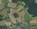
On the south side of Alton Water, Suffolk, UK.
Participants
Plans
Expedition one of two spanning midnight - 2015-07-26 51 1 - 2015-07-27 52 0 - ETA 21:46
Expedition
- Arrived. -- Sourcerer (talk) @51.9820,1.1264 21:38, 26 July 2015 (GMT+01:00)

This was a very pleasant location. Alton Water is a man-made reservoir with foot and cycle paths all round it. The small part I sampled was delightful, if damp. The hashpoint was close to the water. Close by, there was a tall poll with a platform on top that looked like a stork's nest. No stork was in evidence. I have only ever seen them in Portugal and Andalusia, much further south. Google reveals that there have been stork sightings. It would be good if they nested. Lower on the same poll there was an owl box with a lot of hissing noises coming out.
The next day I found out that a young man had died nearby. In hot weather he had jumped off the bridge into the reservoir and was unable to swim to the shore. That explained the rows of flowers tied to the bridge railings.
Photos

Proof. @51.9820,1.1264
Track in Google Earth


Achievements
Sourcerer earned the OpenStreetMap achievement
|
Expeditions and Plans
| 2015-07-26 | ||
|---|---|---|
| Young, Australia | Someone went | In the "south-bound" kerb-side lane of the Hume Highway near Young, New South Wales... |
| San Francisco, California | Codae | On a hillside in Martinez, California. |
| Newark, New Jersey | OtherJack, Liz | A thickly wooded front garden in Ridgewood |
| Canterbury, United Kingdom | Sourcerer | On the south side of Alton Water, Suffolk, UK. |
Sourcerer's Expedition Links
2015-07-25 52 0 - 2015-07-26 51 1 - 2015-07-27 52 0 - KML file download of Sourcerer's expeditions for use with Google Earth.