Difference between revisions of "2020-03-29 62 30"
(Created page with "{{subst:Expedition |lat = 62 |lon = 30 |date = 2020-03-29 }}") |
m (Location) |
||
| (3 intermediate revisions by one other user not shown) | |||
| Line 1: | Line 1: | ||
| − | + | {{meetup graticule | |
| − | |||
| − | |||
| − | |||
| − | |||
| − | |||
| − | |||
| − | |||
| − | |||
| lat=62 | | lat=62 | ||
| lon=30 | | lon=30 | ||
| date=2020-03-29 | | date=2020-03-29 | ||
| − | }} | + | }} |
__NOTOC__ | __NOTOC__ | ||
== Location == | == Location == | ||
| − | + | In a forest close to Tervasuontie road, easily accessible. | |
== Participants == | == Participants == | ||
| − | + | *[[User:Kripakko|Kripakko]] | |
| − | |||
== Plans == | == Plans == | ||
| − | + | I planned to visit the point by cycling from Joensuu, the distance would be about 20 kilometres in one way. The weather should be perfect: partly cloudy and 0 °C in the afternoon. | |
== Expedition == | == Expedition == | ||
| − | + | It took me until about four o'clock to leave from home. Almost all roads were clear of snow, and so I could cycle easily. The temperature had decreased to −1 or −2 °C and continued to decrease slightly. I visited a few geocaches along the way, including one at a lean-to (location 62.59926°, 30.03140°; [https://coord.info/GC5H0TQ GC5H0TQ]) where I took a longer break. Eventually I got near the hashpoint where I had to walk the last eighty metres. | |
| + | |||
| + | The hashpoint was in a depression, a very common (in this part of the world, at least) terrain feature created by a melting block of ice at the end of the last ice age. It was elliptical in shape, twenty to thirty metres in diameter and two or three metres in depth, and the edges were rather steep and clearly defined. There was a thick layer of snow at the bottom, and I could literally walk on it. This is known as crusted snow, and it forms when snow melts and freezes repeatedly, eventually creating a hard surface layer that can support a walking person. I do not feel like this should count as a [[Water geohash achievement|Water Geohash]] though. | ||
| − | + | After leaving the hashpoint, I visited a few more geocaches. I finally got home at about nine o'clock, by which time it had got dark. The total cycled distance was 49.2 kilometres. | |
| − | |||
== Photos == | == Photos == | ||
| − | <!-- | + | <gallery perrow="4"> |
| − | + | 2020-03-29_62_30_01-leanto.jpg | The lean-to that I visited on the way. | |
| − | -- | + | 2020-03-29_62_30_02-bicycle.jpg | The bicycle parked at the roadside, eighty metres to go. |
| − | + | 2020-03-29_62_30_03-gpsr.jpg | Hashpoint reached! | |
| + | 2020-03-29_62_30_05-sun.jpg | The sun illuminating the hashpoint, also showing the edge of the depression. | ||
| + | 2020-03-29_62_30_04-selfie.jpg | Selfie at the hashpoint. | ||
| + | 2020-03-29_62_30_06-crystals.jpg | Showing that the temperature is freezing: these ice crystals (crushed crusted snow) can only exist at below 0 °C. At 0 °C they would start to melt and form larger clumps. | ||
| + | 2020-03-29_62_30_07-footprint.jpg | Stereo image of my footprint in the crusted snow. You can see that it is about 1 cm deep. | ||
| + | 2020-03-29_62_30_08-kilometrepost.jpg | An old kilometre post (like a milestone, but here the distances are obviously measured in kilometres). | ||
</gallery> | </gallery> | ||
== Achievements == | == Achievements == | ||
{{#vardefine:ribbonwidth|800px}} | {{#vardefine:ribbonwidth|800px}} | ||
| − | + | {{land geohash | latitude = 62 | longitude = 30 | date = 2020-03-29 | name = Kripakko}} | |
| − | + | {{bicycle geohash | latitude = 62 | longitude = 30 | date = 2020-03-29 | name = Kripakko | distance = 49.2 km | bothways = true}} | |
| − | + | {{Frozen Geohash | latitude = 62 | longitude = 30 | date = 2020-03-29 | name = Kripakko }} | |
| − | |||
| − | |||
| − | |||
| − | |||
| − | |||
| − | |||
| − | |||
| − | |||
| − | |||
| − | |||
| − | |||
| − | |||
[[Category:Expeditions]] | [[Category:Expeditions]] | ||
| − | |||
[[Category:Expeditions with photos]] | [[Category:Expeditions with photos]] | ||
| − | |||
| − | |||
| − | |||
| − | |||
| − | |||
[[Category:Coordinates reached]] | [[Category:Coordinates reached]] | ||
| − | + | {{location|FI|13}} | |
| − | |||
| − | |||
| − | |||
| − | |||
| − | |||
| − | |||
| − | |||
| − | |||
| − | |||
| − | |||
| − | |||
| − | |||
| − | |||
| − | |||
| − | |||
| − | |||
| − | |||
Latest revision as of 19:42, 30 March 2020
| Sun 29 Mar 2020 in 62,30: 62.5877257, 30.0758101 geohashing.info google osm bing/os kml crox |
Location
In a forest close to Tervasuontie road, easily accessible.
Participants
Plans
I planned to visit the point by cycling from Joensuu, the distance would be about 20 kilometres in one way. The weather should be perfect: partly cloudy and 0 °C in the afternoon.
Expedition
It took me until about four o'clock to leave from home. Almost all roads were clear of snow, and so I could cycle easily. The temperature had decreased to −1 or −2 °C and continued to decrease slightly. I visited a few geocaches along the way, including one at a lean-to (location 62.59926°, 30.03140°; GC5H0TQ) where I took a longer break. Eventually I got near the hashpoint where I had to walk the last eighty metres.
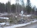
The hashpoint was in a depression, a very common (in this part of the world, at least) terrain feature created by a melting block of ice at the end of the last ice age. It was elliptical in shape, twenty to thirty metres in diameter and two or three metres in depth, and the edges were rather steep and clearly defined. There was a thick layer of snow at the bottom, and I could literally walk on it. This is known as crusted snow, and it forms when snow melts and freezes repeatedly, eventually creating a hard surface layer that can support a walking person. I do not feel like this should count as a Water Geohash though.
After leaving the hashpoint, I visited a few more geocaches. I finally got home at about nine o'clock, by which time it had got dark. The total cycled distance was 49.2 kilometres.
Photos
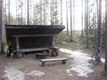
The lean-to that I visited on the way.
The bicycle parked at the roadside, eighty metres to go.
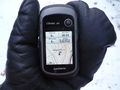
Hashpoint reached!
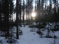
The sun illuminating the hashpoint, also showing the edge of the depression.
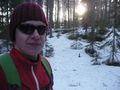
Selfie at the hashpoint.
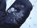
Showing that the temperature is freezing: these ice crystals (crushed crusted snow) can only exist at below 0 °C. At 0 °C they would start to melt and form larger clumps.
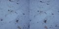
Stereo image of my footprint in the crusted snow. You can see that it is about 1 cm deep.
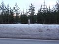
An old kilometre post (like a milestone, but here the distances are obviously measured in kilometres).


Achievements
Kripakko earned the Land geohash achievement
|
Kripakko earned the Bicycle geohash achievement
|
Kripakko earned the Frozen Geohash Achievement
|