Difference between revisions of "2018-08-26 48 8"
From Geohashing
imported>Kellerkind (Created page with "{{meetup graticule | lat=48 | lon=8 | date=2018-07-27 }} __NOTOC__ == Location == In the Hardtwald, south of Karlsruhe. == Participants == Kellerkind...") |
m (Location correction) |
||
| (4 intermediate revisions by 3 users not shown) | |||
| Line 2: | Line 2: | ||
| lat=48 | | lat=48 | ||
| lon=8 | | lon=8 | ||
| − | | date=2018- | + | | date=2018-08-26 |
}} | }} | ||
__NOTOC__ | __NOTOC__ | ||
| Line 31: | Line 31: | ||
Image:2018-08-26_48_8-0.png | Proof | Image:2018-08-26_48_8-0.png | Proof | ||
</gallery> | </gallery> | ||
| + | |||
| + | {{Two to the N achievement | ||
| + | | count = 3 | ||
| + | | date = 2018-08-26 | ||
| + | | latitude = 48 | ||
| + | | longitude = 8 | ||
| + | | reached = true | ||
| + | }} | ||
[[Category:Expeditions]] | [[Category:Expeditions]] | ||
[[Category:Expeditions with photos]] | [[Category:Expeditions with photos]] | ||
[[Category:Coordinates reached]] | [[Category:Coordinates reached]] | ||
| + | {{location|DE|BW|KA}} | ||
Latest revision as of 20:39, 16 May 2020
| Sun 26 Aug 2018 in 48,8: 48.9215015, 8.3355937 geohashing.info google osm bing/os kml crox |
Location
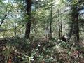
In the Hardtwald, south of Karlsruhe.
Participants
Plans
Go there by bike and maybe look at the old bunkers close to the hash. Maybe try to find a few geocaches along the way.
Expedition
I took my mom's E-Bike to go there. Found this geocache.
Tracklog
Photos
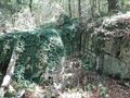
Sign next to the bunker ("Accident hazard" "No trespassing")
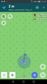
Proof


This user earned the Two to the N achievement
|