Difference between revisions of "2017-03-04 -37 144"
imported>The Man Himself (→Participants) |
m (More specific location) |
||
| (11 intermediate revisions by 4 users not shown) | |||
| Line 26: | Line 26: | ||
<!-- who attended: If you link to your wiki user name in this section, your expedition will be picked up by the various statistics generated for geohashing. You may use three tildes ~ as a shortcut to automatically insert the user signature of the account you are editing with. | <!-- who attended: If you link to your wiki user name in this section, your expedition will be picked up by the various statistics generated for geohashing. You may use three tildes ~ as a shortcut to automatically insert the user signature of the account you are editing with. | ||
--> | --> | ||
| − | + | [[User:The Man Himself|The Man Himself]] ([[User talk:The Man Himself|talk]]) | |
== Plans == | == Plans == | ||
<!-- what were the original plans --> | <!-- what were the original plans --> | ||
| + | |||
| + | When I checked my emails this morning, I found that my geohashing notification had gone off and found, unfortunately, that the hash was near Altona Beach, 9 kilometres away and much too far for me, a 14 year-old boy. Then, luckily, my Mum said that we were going to Altona Beach. On the way I explained Geohashing to her and she said I could go to the hash after the barbecue and swim at the beach. | ||
== Expedition == | == Expedition == | ||
<!-- how it all turned out. your narrative goes here. --> | <!-- how it all turned out. your narrative goes here. --> | ||
| + | I left from 100 Steps Park, Altona Meadows, with nothing but a wide-brimmed hat, bottle and phone. I walked 2.9 kilometres to the hash, finding no one there, unfortunately. I took pictures. Caught a bus to Laverton Station then walked the remaining 8 or so kilometres to Ashcroft Avenue, where I got picked up. | ||
== Tracklog == | == Tracklog == | ||
<!-- if your GPS device keeps a log, you may post a link here --> | <!-- if your GPS device keeps a log, you may post a link here --> | ||
| − | == Photos == | + | ==Photos== |
| − | < | + | <gallery> |
| − | + | [[File:Metrugs.jpg|200px|thumb|left|Me at the hashpoint]] [[File:Featherbyreserve.jpg|200px|thumb|left|Sign of the Reserve the hash was in: goo.gl/kJNrAe ]] | |
| − | + | </gallery> | |
| − | <gallery perrow=" | + | |
| + | <gallery widths="320px" heights="213px" perrow="3"> | ||
| + | Image:Metrugs.jpg | Me at the hashpoint | ||
| + | Image:Featherbyreserve.jpg | Sign of the reserve the hash was in (see [http://goo.gl/kJNrAe here]) | ||
</gallery> | </gallery> | ||
| Line 47: | Line 53: | ||
{{#vardefine:ribbonwidth|800px}} | {{#vardefine:ribbonwidth|800px}} | ||
<!-- Add any achievement ribbons you earned below, or remove this section --> | <!-- Add any achievement ribbons you earned below, or remove this section --> | ||
| + | {{land geohash | ||
| + | | latitude = -37 | ||
| + | | longitude = 144 | ||
| + | | date = 2017-03-04 | ||
| + | | name = The Man Himself | ||
| − | + | }} | |
| − | + | {{Two to the N achievement | |
| − | + | | count = 0 | |
| − | + | | date = 2017-03-04 | |
| − | + | | latitude = -37 | |
| − | + | | longitude = 144 | |
| − | + | | name = The Man Himself | |
| − | + | | reached = true | |
| − | + | }} | |
| − | |||
| − | |||
| − | |||
| − | |||
[[Category:Expeditions]] | [[Category:Expeditions]] | ||
| − | |||
[[Category:Expeditions with photos]] | [[Category:Expeditions with photos]] | ||
| − | |||
| − | |||
| − | |||
| − | |||
| − | |||
[[Category:Coordinates reached]] | [[Category:Coordinates reached]] | ||
| − | + | {{location|AU|VIC|HB}} | |
| − | |||
| − | |||
| − | |||
| − | |||
| − | |||
| − | |||
| − | |||
| − | |||
| − | |||
| − | |||
| − | |||
| − | |||
| − | |||
| − | |||
| − | |||
| − | |||
| − | |||
Latest revision as of 12:52, 1 August 2020
| Sat 4 Mar 2017 in -37,144: -37.8905946, 144.7783716 geohashing.info google osm bing/os kml crox |
Location
At Skeleton Creek, before where it empties out to the sea
Participants
Plans
When I checked my emails this morning, I found that my geohashing notification had gone off and found, unfortunately, that the hash was near Altona Beach, 9 kilometres away and much too far for me, a 14 year-old boy. Then, luckily, my Mum said that we were going to Altona Beach. On the way I explained Geohashing to her and she said I could go to the hash after the barbecue and swim at the beach.
Expedition
I left from 100 Steps Park, Altona Meadows, with nothing but a wide-brimmed hat, bottle and phone. I walked 2.9 kilometres to the hash, finding no one there, unfortunately. I took pictures. Caught a bus to Laverton Station then walked the remaining 8 or so kilometres to Ashcroft Avenue, where I got picked up.
Tracklog
Photos
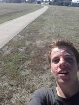
Me at the hashpoint
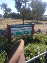
Sign of the reserve the hash was in (see here)


Achievements
The Man Himself earned the Land geohash achievement
|
