Difference between revisions of "2010-07-05 50 -119"
imported>Jiml m (Copy Data - Go to the Help Page on the left sidebar and choose "Reporting on your expedition") |
m (More specific location) |
||
| (2 intermediate revisions by 2 users not shown) | |||
| Line 1: | Line 1: | ||
| − | |||
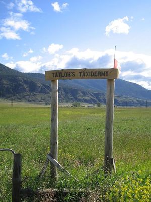
| − | [[Image: | + | [[Image:2010-07-05 50 -119.gate.jpg|thumb|left|Straight through the gate.]] |
| − | |||
| − | |||
{{meetup graticule | {{meetup graticule | ||
| lat=50 | | lat=50 | ||
| Line 17: | Line 14: | ||
The geohash is in the middle of a field next to highway 97, just east of Westwold. | The geohash is in the middle of a field next to highway 97, just east of Westwold. | ||
| − | |||
== Participants == | == Participants == | ||
| Line 27: | Line 23: | ||
== Expedition == | == Expedition == | ||
| + | |||
| + | [[Image:2010-07-05 50 -119.gps.jpg|thumb|left]] | ||
Took a detour on the drive between Vancouver and Salmon Arm to drive through Westwold along a road that bore the name highway 97, but was definitely not in the 97th percentile of highway quality ranking. Approaching the point, it looked as if this would be a detour for nothing, because all the fields were fenced and many had livestock in them. I drove by the field itself, and it was fenced. There was no real crop in the field, just a mixture of grasses, but there was an irrigation system installed, so perhaps they were going to mow it for hay. I parked in a side road, in order to walk back and get the best picture. The fence was solid and while there were no signs, I wouldn't cross a fence like that. | Took a detour on the drive between Vancouver and Salmon Arm to drive through Westwold along a road that bore the name highway 97, but was definitely not in the 97th percentile of highway quality ranking. Approaching the point, it looked as if this would be a detour for nothing, because all the fields were fenced and many had livestock in them. I drove by the field itself, and it was fenced. There was no real crop in the field, just a mixture of grasses, but there was an irrigation system installed, so perhaps they were going to mow it for hay. I parked in a side road, in order to walk back and get the best picture. The fence was solid and while there were no signs, I wouldn't cross a fence like that. | ||
| Line 32: | Line 30: | ||
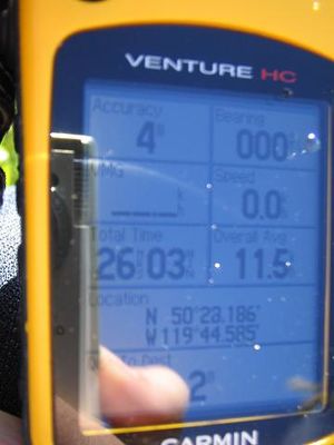
The distance from the geohash reached a minimum at 268 metres, so I took a couple of pictures and then walked on a little further to get a different angle. And then I came to the open gate, next to an archway designating a taxidermy business. An open gate, nothing to harm in the field, a quick romp through 300 metres of tall wet gress and I returned with jeans wet to the thighs, soggy shoes, and a photo of the geohash. | The distance from the geohash reached a minimum at 268 metres, so I took a couple of pictures and then walked on a little further to get a different angle. And then I came to the open gate, next to an archway designating a taxidermy business. An open gate, nothing to harm in the field, a quick romp through 300 metres of tall wet gress and I returned with jeans wet to the thighs, soggy shoes, and a photo of the geohash. | ||
| − | Back in the car | + | Back in the car and on to Salmon River, where I bought some cumin gouda cheese before ending up in Salmon Arm. |
| − | |||
| − | |||
| − | |||
| − | |||
| − | |||
| − | |||
| − | |||
| − | |||
| − | |||
| − | |||
| − | |||
| − | |||
| − | |||
| − | |||
| − | |||
| − | |||
| − | |||
| Line 56: | Line 37: | ||
[[Category:Expeditions with photos]] | [[Category:Expeditions with photos]] | ||
[[Category:Coordinates reached]] | [[Category:Coordinates reached]] | ||
| + | {{location|CA|BC|TN}} | ||
Latest revision as of 23:26, 9 August 2020
| Mon 5 Jul 2010 in 50,-119: 50.4697853, -119.7430819 geohashing.info google osm bing/os kml crox |
Location
The geohash is in the middle of a field next to highway 97, just east of Westwold.
Participants
- Robyn & T-Rex, of course
Plans
Attempting this one between eleven and noon.
Expedition
Took a detour on the drive between Vancouver and Salmon Arm to drive through Westwold along a road that bore the name highway 97, but was definitely not in the 97th percentile of highway quality ranking. Approaching the point, it looked as if this would be a detour for nothing, because all the fields were fenced and many had livestock in them. I drove by the field itself, and it was fenced. There was no real crop in the field, just a mixture of grasses, but there was an irrigation system installed, so perhaps they were going to mow it for hay. I parked in a side road, in order to walk back and get the best picture. The fence was solid and while there were no signs, I wouldn't cross a fence like that.
The distance from the geohash reached a minimum at 268 metres, so I took a couple of pictures and then walked on a little further to get a different angle. And then I came to the open gate, next to an archway designating a taxidermy business. An open gate, nothing to harm in the field, a quick romp through 300 metres of tall wet gress and I returned with jeans wet to the thighs, soggy shoes, and a photo of the geohash.
Back in the car and on to Salmon River, where I bought some cumin gouda cheese before ending up in Salmon Arm.

