Difference between revisions of "2010-10-05 54 -112"
imported>FippeBot m (Location) |
m (More specific location) |
||
| Line 53: | Line 53: | ||
[[Category:Coordinates reached]] | [[Category:Coordinates reached]] | ||
[[Category:Expeditions with photos]] | [[Category:Expeditions with photos]] | ||
| − | {{location|CA|AB}} | + | {{location|CA|AB|SL}} |
Revision as of 23:34, 9 August 2020
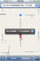
| Tue 5 Oct 2010 in 54,-112: 54.0160605, -112.5299483 geohashing.info google osm bing/os kml crox |
Location
Smack dab in the middle of Range Road 180, just South East of Smokey Lake, Alberta.
Participants
Plans
Another trip back from work at Christina Lake: Phi-loci-raptor was nice enough to research the possible hash points in the between 55,-110 and 53,-113 while I was sleeping and found this gem of a hash. My official excuse for napping was to be rested for the drive after working the night shift, but in reality I was just waiting for the Dow Jones to open. After a long string of false speed racer hashes (damn OS4) I had to triple check that the location was actually on the road, and not another snap to road fiasco.
Expedition
This was a very easy hash that I couldn't pass up. It was only an 11km detour from the highway home, and a nice drive through harvest time wheat fields was is good for the soul. Fully wicked sick bro, one more virgin Albertan graticule for me!
Photos
Starting line
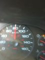
80 km/h is the maximum speed limit for non-primary highways outside an urban area (unless otherwise posted)
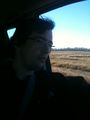
Action shot of my hair blowing in the wind.
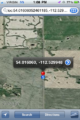
Proof!


Ribbons

B cereus earned the Land geohash achievement
|