Difference between revisions of "2015-04-05 48 16"
imported>B2c (An expedition message sent via Geohash Droid for Android.) |
m (Linking to The Dance™) |
||
| (5 intermediate revisions by 2 users not shown) | |||
| Line 1: | Line 1: | ||
| − | |||
| − | |||
| − | |||
| − | |||
| − | |||
| − | |||
| − | |||
| − | |||
| − | |||
| − | |||
{{meetup graticule | {{meetup graticule | ||
| lat=48 | | lat=48 | ||
| Line 15: | Line 5: | ||
}} | }} | ||
| − | + | ||
| − | |||
== Location == | == Location == | ||
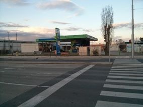
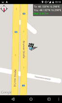
| − | + | [[Image:{{{image|2015-04-05-spot.jpg}}}|thumb|left]] Between a gas station and the B12 Brunner Strasse near the southern Vienna city limits. | |
| + | |||
| + | |||
| + | |||
| + | |||
| + | |||
| + | |||
| + | |||
| + | |||
== Participants == | == Participants == | ||
| − | + | * [[User:Crankl|Crankl]] | |
| − | + | * [[User:B2c|B2c]] | |
| + | |||
== Plans == | == Plans == | ||
| − | + | No specials plans, just grabbing the hash as it was just too easy to pass it up. | |
| + | |||
== Expedition == | == Expedition == | ||
| − | + | B2c was on his way back from a short easter weekend and the hash was on the way so why don't stop by and grab it? Although Micsnare was taking a hash-break because she felt a little under the weather, Crankl was all up for it. After B2c dropped by his flat to drop his luggage, they met near a subway station in Crankls vicinity. At last light they drove out of town and easily reached the hash which was located next to a OMV gas station in Vösendorf, a couple kilometers south of the Vienna city limits. They parked the car across the street, tried to be good citizens and wait for the crosswalk lights to turn green which turned out to be impossible - although the traffic light for the cars turned red, the crosswalk lights never turned green. *Sigh* Hey, traffic dept., you reading this? After walking over to the hash they did [[The Dance™|the dance]], took the photos and were on their way. Easy as pie ;) | |
| + | |||
| + | |||
| + | *Crankl and B2c @ hash -- [[User:B2c|B2c]] ([[User talk:B2c|talk]]) [http://www.openstreetmap.org/?lat=48.13339000&lon=16.29820396&zoom=16&layers=B000FTF @48.1334,16.2982] 19:10, 5 April 2015 (GMT+02:00) | ||
== Tracklog == | == Tracklog == | ||
| − | + | No tracklog this time. | |
| − | == Photos == | + | |
| − | < | + | == Photos == |
| − | Image: | + | <gallery caption="Photo Gallery" widths="320px" heights="213px" perrow="3"> |
| − | -- | + | Image: 2015-04-05-car.jpg | Hash in the distance. |
| − | + | Image: 2015-04-05-crossing.jpg | The crosswalk. | |
| + | Image: 2015-04-05-sign.jpg | Crankl activates the traffic light.. | ||
| + | Image: 2015-04-05-spot2.jpg | Crankl@hash. | ||
| + | Image: 2015-04-05-spot.jpg | The hashpoint right next to the junction box. | ||
| + | Image: 2015-04-05-grin.jpg | Stupid grin (tm). | ||
| + | Image: 2015-04-05-satnav.png | Satnav. | ||
| + | Image: 2015-04-05-proof.png | Proof. | ||
| + | Image: 2015-04-05-moreproof.png | More proof. | ||
</gallery> | </gallery> | ||
| − | |||
| − | |||
| − | |||
| + | == Gratuitous Achievements == | ||
| + | No real achievement, but [[User:Micsnare|Micsnare]] found this somewhere on the wiki, so there you go. | ||
| + | |||
| + | {{Easy_geohash | ||
| + | | latitude = 48 | ||
| + | | longitude = 16 | ||
| + | | date = 2015-04-05 | ||
| + | | name = [[User:Crankl|Crankl]] | ||
| + | }} | ||
| − | + | {{Easy_geohash | |
| − | + | | latitude = 48 | |
| − | [[ | + | | longitude = 16 |
| + | | date = 2015-04-05 | ||
| + | | name = [[User:B2c|B2c]] | ||
| + | }} | ||
| − | |||
| − | |||
| − | |||
| − | |||
| − | |||
| − | |||
[[Category:Expeditions]] | [[Category:Expeditions]] | ||
| − | |||
[[Category:Expeditions with photos]] | [[Category:Expeditions with photos]] | ||
| − | |||
| − | |||
| − | |||
| − | |||
| − | |||
[[Category:Coordinates reached]] | [[Category:Coordinates reached]] | ||
| − | + | {{location|AT|W}} | |
| − | |||
| − | |||
| − | |||
| − | |||
| − | |||
| − | |||
| − | |||
| − | |||
| − | |||
| − | |||
| − | |||
| − | |||
| − | |||
| − | |||
| − | |||
| − | |||
| − | |||
Latest revision as of 17:03, 14 November 2020
| Sun 5 Apr 2015 in 48,16: 48.1333651, 16.2982086 geohashing.info google osm bing/os kml crox |
Contents
[hide]Location

Between a gas station and the B12 Brunner Strasse near the southern Vienna city limits.
Participants
Plans
No specials plans, just grabbing the hash as it was just too easy to pass it up.
Expedition
B2c was on his way back from a short easter weekend and the hash was on the way so why don't stop by and grab it? Although Micsnare was taking a hash-break because she felt a little under the weather, Crankl was all up for it. After B2c dropped by his flat to drop his luggage, they met near a subway station in Crankls vicinity. At last light they drove out of town and easily reached the hash which was located next to a OMV gas station in Vösendorf, a couple kilometers south of the Vienna city limits. They parked the car across the street, tried to be good citizens and wait for the crosswalk lights to turn green which turned out to be impossible - although the traffic light for the cars turned red, the crosswalk lights never turned green. *Sigh* Hey, traffic dept., you reading this? After walking over to the hash they did the dance, took the photos and were on their way. Easy as pie ;)
- Crankl and B2c @ hash -- B2c (talk) @48.1334,16.2982 19:10, 5 April 2015 (GMT+02:00)
Tracklog
No tracklog this time.
Photos
- Photo Gallery

Hash in the distance.
The crosswalk.

Crankl activates the traffic light..
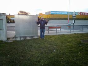
Crankl@hash.

The hashpoint right next to the junction box.

Stupid grin (tm).
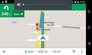
Satnav.
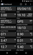
Proof.
More proof.


Gratuitous Achievements
No real achievement, but Micsnare found this somewhere on the wiki, so there you go.
Crankl has visited an Easy Geohash
|
B2c has visited an Easy Geohash
|